
Stratford, London facts for kids
Quick facts for kids Stratford |
|
|---|---|
.jpg) West Ham Town Hall, Stratford |
|

Stratford
|
|
| Population | 36,666 (2019 estimate, Stratford and New Town ward) |
| OS grid reference | TQ385845 |
| • Charing Cross | 6 mi (9.7 km) WSW |
| London borough | |
| Ceremonial county | Greater London |
| Region | |
| Country | England |
| Sovereign state | United Kingdom |
| Post town | LONDON |
| Postcode district | E15, E20 |
| Dialling code | 020 |
| Police | Metropolitan |
| Fire | London |
| Ambulance | London |
| EU Parliament | London |
| UK Parliament |
|
| London Assembly | |
Stratford is a busy town in East London, England. It is part of the London Borough of Newham. Stratford is about 6 miles (10 km) east of Charing Cross, a famous spot in central London. It includes areas like Maryland and East Village.
Long ago, Stratford was part of a parish called West Ham in Essex. In 1965, local government changed in London. West Ham became part of the new London Borough of Newham in Greater London.
Stratford grew very fast in the 1800s after railways arrived in 1839. It became a big part of London. In the late 1900s, the area faced tough times. But things got better with big projects, especially for the 2012 Summer Olympics. The Queen Elizabeth Olympic Park in Stratford was the main place for the Olympics.
The Westfield Stratford City shopping centre, one of Europe's largest, opened in 2011. Today, Stratford is a major place for shopping, culture, and fun in East London. It's also an important business area, second only to Canary Wharf in East London.
Contents
History of Stratford
Stratford became important early on because of a Roman road. This road, later called the Great Essex Road, went from Aldgate in the City across the River Lea. The River Lea and its marshes were a big challenge for travel and trade. They formed a natural border between Essex and Middlesex.
How Stratford Got Its Name
The name "Stratford" was first written down in 1067 as "Strætforda." This means 'ford on a Roman road'. It comes from old English words: 'stræt' (which means 'street') and 'ford'. The old river crossing was somewhere north of Stratford High Street.
The area of Old Ford in northern Bow is named after this old crossing. Bow itself was also first called Stratford. People added different endings to tell the two places apart, like Stratford-le-Bow.
The settlement east of the River Lea was also called Estratford (meaning east of the other Stratford). It was also known as Statford Hamme (because it was in West Ham parish) and Abbei Stratford (because of Stratford Langthorne Abbey). The name Stretford Langthorne (from 1366) came from a special thorn tree in the area. This tree was mentioned as early as 958 AD. It is thought to have stood near the modern Channel Sea rail junction.
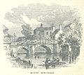
Building Bow Bridge
In 1110, Matilda, the wife of King Henry I, ordered a special arched bridge to be built over the River Lea. She also had a raised road (causeway) built across the marshes. This is now Stratford High Street. Stories say she had trouble crossing the river to get to Barking Abbey.
After this, the western Stratford became known as "Bow" (from the arched bridge). Over time, the eastern Stratford lost its "Langthorne" part and became simply Stratford.
_p18b_-_Bow_Bridge.jpg)
The bridge was fixed and improved many times over hundreds of years. It was finally taken down and replaced in the 1800s.
Stratford Langthorne Abbey
In 1135, the Cistercian monks started Stratford Langthorne Abbey. It was also called West Ham Abbey. This became one of England's biggest and richest monasteries. It owned 1,500 acres (607 hectares) nearby and 20 manors across Essex.
The Abbey was located between the Channelsea River and Marsh Lane. Nothing visible remains today. After King Henry VIII closed it in 1538, local landowners used its stones for their own buildings. The land was later built over.
A stone window and a carving of skulls from the Abbey can still be seen at All Saints Church, West Ham (built around 1180). The Abbey's Great Gate stood until 1825.

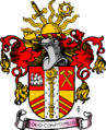
The entrance to the Old Court House in Tramway Avenue, Stratford, shows the Abbey's coat of arms. These symbols were later used in the coat of arms for the old County Borough of West Ham in 1887. The new London Borough of Newham uses the same arms today.
Stratford's Industrial Growth
Stratford's journey into industry began slowly but sped up a lot in the early 1800s.
.jpg)

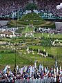
The story of Stratford's industrial growth was even shown in the 2012 Summer Olympics Opening Ceremony. It showed how the area changed from a green, peaceful place to a busy, noisy industrial hub. This huge change made West Ham known as the "Factory centre of the south of England." Stratford had the most factories in West Ham.
Life Before Factories
Stratford was first a farming area. Being close to London meant it had a good market for its crops. By the 1700s, Stratford was famous for growing potatoes. This continued until the mid-1800s. Wealthy merchants and bankers also liked Stratford as a country escape, being an easy ride from the City.
When Daniel Defoe visited in 1722, he said Stratford had "increased in buildings to a strange degree." He noted that these new buildings were "handsome large houses" for rich citizens who either had two homes (one in the country, one in the city) or had retired and lived in these nearby villages for pleasure and health.
First Factories
One of the first factories in Stratford was the Bow porcelain factory. Even though it was called "Bow," it was on the Essex side of the River Lea. In 1744, Edward Heylin and Thomas Frye opened a factory called "New Canton" near Bow Bridge. They made some of the first soft-paste porcelain in England. This factory site was north of Stratford High Street.
Fast Growth in Victorian Times
The Victorian era saw huge growth in Stratford because of three main things: a new building law, the arrival of the railway, and the creation of the nearby Royal Docks.
The Metropolitan Building Act of 1844 helped Stratford grow fast. This law stopped dangerous factories from operating in central London. So, many of these factories moved to the banks of the River Lea. West Ham became a major centre for making medicines, chemicals, and processed foods. This quick growth earned it the name "London over the border."
By the early 1800s, Stratford was a key transport hub. Buses and coaches ran to London often. A small dock and wharves on the River Lea served local businesses. The opening of the Victoria Dock (later Royal Victoria Dock) in 1855, and then the larger Royal Group of Docks, made Stratford even more important for transport and manufacturing.

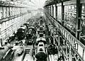
Stratford station opened on June 20, 1839. A railway workshop and depot for trains was built north of Stratford in 1847. At its busiest, the works employed over 2,500 people. Many of them, and other railway workers, lived in the new town that grew nearby. This town was first called Hudson Town, but after a scandal, it became known as Stratford New Town. By 1862, it had 20,000 people. The Stratford works built many locomotives, passenger coaches, and goods wagons. The last part of the works closed in 1991.
20th Century Changes
Like many parts of London, especially the East End, Stratford lost many of its factories in the 1900s. This was made worse when the London Docks closed in the 1960s. Around this time, the Stratford Shopping Centre was built. This was the start of changing the area from a working-class industrial hub to a place for shopping and fun. These efforts continued with the bid for the Olympics and the ongoing projects to improve the area.
Stratford Today
Geography of Stratford
Stratford started as a small village in the northwest of the old parish of West Ham. As it grew, it joined with nearby areas.
Stratford has never been a formal administrative area on its own. So, like many London districts, it doesn't have exact borders. However, it covers the northwest part of West Ham. This area's boundaries are now the northwest boundaries of the modern London Borough of Newham.
The River Lea and the many channels of the Bow Back Rivers form the western edge of Stratford. The area also goes north to the border of the London Borough of Waltham Forest.
Most of Stratford is in the E15 postal area. However, the Royal Mail gave the new E20 postcode to the Olympic Park and Stratford City developments. This postcode was previously only used for the fictional East London setting of "Walford" in the BBC TV show EastEnders. The name "Walford" is a mix of nearby Walthamstow and Stratford.
 |
Hackney Wick | Temple Mills and Hackney Marsh | Leyton | |
| Bow and Old Ford | Forest Gate | |||
| Bromley-by-Bow | Central West Ham | Plaistow |
Local Government in Stratford
Stratford was one of three old areas in the large parish of West Ham in Essex. It became part of the Metropolitan Police District in 1840.

Even though it was part of London's built-up area, the parish was not included in the main metropolitan area until later. Instead, local government changes happened as they would in a large town. In 1889, West Ham became a county borough. This meant it was outside the control of Essex County Council. Stratford was the main administrative centre for the county borough and had the town hall.
In 1965, after new laws about local government in London, West Ham joined with East Ham and other small areas. They formed the London Borough of Newham, which is part of the new Greater London.
Who Represents Stratford?
Stratford is in the West Ham area for the UK Parliament. Since 2005, Lyn Brown from the Labour Party has been the Member of Parliament.
Stratford is also part of the area led by the Mayor of Newham. This mayor is chosen by local people. Rokhsana Fiaz has been the Mayor since May 4, 2018.
The modern borough has an election area called 'Stratford and New Town'.
Parks in Stratford
Queen Elizabeth Olympic Park
Most of the 560-acre (227-hectare) Queen Elizabeth Olympic Park is in Stratford. Other parts are in the London Borough of Tower Hamlets, London Borough of Hackney, and London Borough of Waltham Forest. This park was built for the 2012 Summer Olympics and opened to the public for good in 2014.
The park has many sports venues and large open spaces. Since the Olympics, some open areas have been used for new cultural places, businesses, and homes.
Stratford Park
Stratford Park on West Ham Lane was created in stages between 1899 and 1912. It was first called West Ham Recreation Ground and many still call it West Ham Rec. The name changed in 1999 to avoid confusion with nearby West Ham Park.
Before the council bought the land, a football club called Castle Swifts F.C. used the open plot opposite West Ham Police Station in 1892–93. They named it Dunottar Park. This club later joined with Thames Ironworks F.C., which became West Ham United F.C..
Famous Places in Stratford
Gurney Memorial Drinking Fountain
South of the churchyard stands a 12.80-metre (42-foot) tall granite obelisk. It was put up in 1861 to remember Samuel Gurney (1766–1856). He was a Quaker who worked to end slavery. The base has two brass drinking fountains and a message: "IN REMEMBRANCE OF SAMUEL GURNEY / WHO DIED 5 June 1856 / ERECTED BY HIS FELLOW PARISHIONERS AND FRIENDS / 1861 / 'When the ear heard him then it blessed him'".
Old Town Hall
The Stratford Town Hall opened in 1869. It was designed by Lewis Angell and John Giles in the Italianate style. It has a 100-foot (30-metre) tall domed tower. It was first used as offices for the West Ham local health board. Later, it became the town hall for the county borough and was made bigger in 1881 to add a courthouse and cells. On June 26, 1982, a fire badly damaged the main part of the building. After careful rebuilding and updating, it reopened in July 1986. It is a Grade II listed building. The balcony of the Old Town Hall has been used for celebrations when West Ham United FC won big trophies.
King Edward VII Pub
Across from St John's Church is an old pub from the early 1800s, called the King Edward VII. It has its original doors and windows. It is a Grade II listed building.
It was first called "The King of Prussia". This was either to honour Frederick the Great or King Frederick William IV, who visited the area in 1842.
In 1914, at the start of World War One, the pub was renamed for King Edward VII, who had died in 1910. The old name was a problem because 'The King of Prussia' was one of the titles of the German Emperor, Kaiser Wilhelm II. More than a hundred years later, the King Edward VII pub is still sometimes called 'The Prussian' by locals.
Robert the Tank Engine

A 38-tonne (37-long-ton) steam train called Robert is on display in Meridian Square, outside Stratford Station. It was built in 1933 by the Avonside Engine Company for a railway at the Lamport Ironstone mines. It used to be at the North Woolwich Old Station Museum. It moved to Stratford in 1999, then to the East Anglia Railway Museum in 2008 for cleaning and repainting. It came back to Stratford in 2011.
ArcelorMittal Orbit

This is a 114-metre (374-foot) tall sculpture and observation tower in the Queen Elizabeth Olympic Park. It is Britain's largest piece of public art. It was built to be a lasting reminder of the 2012 Summer Olympics. It closed after the Games but reopened to the public in April 2014.
Abbey Mills Pumping Stations

Built in 1868 by Sir Joseph Bazalgette, these buildings were part of London's new sewerage system. They originally held steam pumps. The building is a great example of Italian-style Gothic Revival architecture. It is sometimes open to the public, where you can see its "flamboyant interior of enriched cast ironwork." It was used as a mental hospital in the 2005 film Batman Begins and is a Grade II* listed building.
Churches in Stratford

The main Church of England parish church in Stratford is St John's. It was built in the 1830s and is on Stratford Broadway. It is a Grade II listed building. In its churchyard is a memorial to the Stratford Martyrs. These people were burned at the stake in 1556 (likely in Bow) during the reign of Queen Mary. The memorial was unveiled in 1878.
St Francis of Assisi Church, Stratford is the Roman Catholic church in Stratford. It was built in 1868 and is run by Franciscan Friars.
People of Stratford
Who Lives in Stratford?
According to the 2011 census, the largest group of people in the Stratford and New Town area are White British (21%). The next largest group is Other White (19%), followed by Black African (13%). Other ethnic groups make up the remaining 47%.
Religions in Stratford
The two main religions in Stratford are Christianity and Islam. There are 8,106 Christians and 3,643 Muslims living in the area.
Economy and Shopping

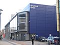
Stratford has two main shopping centres: the Stratford Centre and the newer (opened 2011) Westfield Stratford City. They are on opposite sides of Stratford station. Westfield Stratford City has 350 stores and is one of Europe's largest shopping centres. The older Stratford Centre has more affordable shops, indoor and outdoor market stalls, and small retail shops.
New Developments in Stratford
Stratford has been a focus for new developments for many years as its local economy has grown.


Here are some of the big projects:
- Westfield Stratford City is a huge project that cost billions of pounds. It rebuilt 73 hectares (180 acres) of old railway land north of the town centre. This massive shopping centre, bigger than Bluewater, opened in September 2011. It has major stores like John Lewis, Waitrose, and Marks and Spencer, plus other well-known brands like Apple and Primark. The centre also has many restaurants, a cinema, and a casino, making it a fun place to visit, not just for shopping. Nearby, a new community with 5,000 homes, offices, schools, and public spaces was built. This area is becoming a major centre for East London.
- The 2012 Olympic and Paralympic Games had their main base at the Olympic Park. This park had many venues, including the Olympic Stadium, Aquatics Centre, and London Velopark. What was the athletes' Olympic Village is now the new East Village development, offering 3,500 homes. The plans for after the Olympics included the largest new urban park in Europe in over a century, and the new Chobham Academy.
- Stratford station has been improved with new platforms, walkways, and entrances.
- Pudding Mill Lane DLR station was rebuilt as part of the Crossrail project.
- 150 High Street, Stratford is a 41-storey, 133-metre (436-foot) tall residential tower.
- A 26-acre (11-hectare) development called Sugar House Island at Mill Meads is expected to create 2,500 jobs. It will also have 1,200 homes, a new school, a 350-bed hotel, and new facilities for local people.
- Morgan House and the southern end of the Stratford Centre are being redeveloped into new offices, a hotel, and two residential towers (42 and 21 storeys).
Olympic Park developments:
- The East Wick & Sweetwater neighbourhoods will have up to 1,500 homes.
- Olympicopolis is a plan in the Olympic Park for the Victoria & Albert Museum and University College London to have facilities.
- International Quarter London will have 13 office buildings, 2 residential buildings, and a hotel.
Entertainment in Stratford
.jpg)
Stratford's Cultural Quarter, next to the shopping centre, has several arts venues, bars, and cafes. The Theatre Royal Stratford East was designed by James George Buckle in 1884. The "East" in its name helps tell it apart from Stratford-upon-Avon. Stratford Circus is a modern performing arts venue that opened in 2001.
The Discover Children's Story Centre is also part of the Cultural Quarter. It has special play spaces called Story World and Story Garden. It works with schools, libraries, and the local community.
Stratford in Films
Stratford has been used as a filming location for many movies. These include Sparrows Can't Sing (1963), Bronco Bullfrog (1970), Batman Begins (2005), and Attack the Block (2011). The music video for The Beatles' song "Penny Lane" was filmed around Angel Lane in Stratford.
Sport in Stratford
Stratford is home to the Queen Elizabeth Olympic Park. This sports complex was built for the 2012 Summer Olympics and Paralympics. It is named after Queen Elizabeth II to mark her Diamond Jubilee.
The first annual Invictus Games were held in the park from September 10 to 14, 2014. Events took place at many venues used during the 2012 Olympics. 300 competitors from 13 countries took part.
The Premier League football club West Ham United F.C. is based in Stratford Queen Elizabeth Olympic Park. From 1904 to 2016, the club's home ground was Boleyn Ground in Upton Park. In 2016, West Ham moved to a new multi-purpose ground, the London Stadium. This stadium is also home to UK Athletics (British Athletics), who share it with West Ham. The stadium has hosted some 2015 Rugby World Cup and English rugby union matches. It also hosted the 2017 IAAF World Championships and the 2017 World Para Athletics Championships.
The London Aquatics Centre is also in the park. It has an indoor facility with two 50-metre (160-foot) swimming pools and a 25-metre (82-foot) diving pool.
Education in Stratford

The University of East London (UEL) has a major campus in Stratford. Its main building, University House, is a historic listed building from the 1800s. The nearby Passmore Edwards Building is also a beautiful historic building with colorful paintings and a domed roof. Also, Birkbeck College, part of the University of London, has started courses in the area.
Newham College of Further Education has a campus in Stratford that opened in 1993. In April 2016, the college announced a partnership with the University of East London.
The Chobham Academy is a school in the Stratford area of East Village. It opened in September 2013. It is an education campus with a nursery, primary school, secondary school, sixth form, and adult learning centre.
Sarah Bonnell School is one of England's oldest girls' schools. It is now a girls-only secondary school. It moved to its current site from Forest Gate.
The Carpenters Primary School is a state school in the Carpenters Estate. The Worshipful Company of Carpenters has strong ties with the school and gives it regular grants. The school is built next to the original Carpenters' Institute.
Other schools in Stratford include Colegrave, John F Kennedy, and also St Francis and Maryland in the area of Maryland.
Transport in Stratford
Trains and Underground

National Rail Services
Stratford is a very important train station. It is on the Great Eastern Main Line, North London Line, Elizabeth Line, and Lea Valley Lines. In 2017–18, over 40 million passengers used the station, making it the 7th busiest in the UK. The Elizabeth Line manages the station.
Several train companies use this station:
- Greater Anglia trains go to places in East Anglia, like Southend Victoria, Colchester Town, Ipswich, and Norwich. The Lea Valley Lines go towards Tottenham Hale and Bishop's Stortford.
- Elizabeth Line trains run between Shenfield, Romford, Liverpool Street, Bond Street, Paddington, and Heathrow Terminal 4/Heathrow Terminal 5.
- London Overground trains follow the North London Line towards Highbury & Islington, going through Gospel Oak and Willesden Junction towards Richmond or Clapham Junction.
Stratford International, located to the north-west, is on the High Speed 1 line from St Pancras to Kent. It is served by Southeastern's fast domestic trains. The international and national rail stations are connected by a branch of the Docklands Light Railway, which opened in August 2011.
Maryland railway station is in the eastern part of Stratford town centre. It is a stop on the Elizabeth Line.
London Underground (Tube)
Stratford has two London Underground (Tube) lines:
- The Central line runs east-west through central London. It connects Stratford with Epping, Liverpool Street, Oxford Circus, and Ealing Broadway.
- The Jubilee line was extended to Stratford in 1999. It provides services to Stanmore, Wembley Park, Bond Street, and Canary Wharf.
Docklands Light Railway (DLR)
The Docklands Light Railway (DLR) was extended to Stratford in 1987 and to Stratford International in 2011. DLR trains connect Stratford to Poplar, Canary Wharf, Lewisham, London City Airport, the Excel Centre, Beckton, and Woolwich Arsenal.
Pudding Mill Lane is south of the Olympic Park and west of Stratford town centre. It usually serves local factories. It was moved south as part of the Crossrail project.
Stratford High Street is south of Stratford Regional station, on the site of the old Stratford Market railway station.
Buses and Coaches
Stratford bus station is next to Stratford Regional station and the Stratford Centre. It is served by London Buses.
London Buses go to places in the West and East End, northeast, and south London.
A newer bus station, Stratford City bus station, opened in 2011 as part of the Westfield Stratford City project. National Express coaches run from Stratford City bus station to Stansted Airport and other places in East Anglia. Megabus coaches also stop here, with a direct service to Norwich.
Roads
Stratford is connected to the main road network by several important roads.
The A12 goes through Stratford, carrying eastbound traffic from London towards the North Circular, the M25, the M11, and East Anglia. The A11 connects the City and Stratford. Transport for London (TfL) manages the A11 and A12 roads.
Stratford High Street is called the A118. The A112 is a north-south road through Stratford.
All roads in Stratford are part of London's Low Emission Zone.
Air Quality
Newham Council checks pollution levels by the roads. In a 2018 report, Leytonstone Road in Stratford had the highest level of Nitrogen Dioxide (NO2) in roadside air in Newham. Nitrogen Dioxide can affect breathing and lung function.
Cycling
Stratford is connected to London's cycle network. Transport for London (TfL) and Newham Council provide cycling paths.
The eastern end of Cycle Superhighway 2 (CS2) is on Stratford High Street. CS2 has special segregated cycle tracks. CS2 was the first fully separated Cycle Superhighway in London.
Quietway 6 goes through the north of Stratford. Quietway 22 runs from Victoria Park, over Stratford High Street, towards Plaistow and Beckton. Quietways are marked routes on quieter roads.
National Cycle Route 1 (NCN1) runs along the Hertford Union Canal and Lee Navigation towpaths near Stratford. Cycling is allowed on these towpaths, which are shared-use paths.
The Santander Cycles bike-sharing scheme also works in Stratford.
Between 2010 and 2014, Stratford High Street had 153 bicycle accidents. However, by 2016, there were only 79 serious cyclist injuries in the whole borough, with no deaths. The council has a "cycling strategy" to improve cycling facilities.
Media
The Newham Recorder provides local news for the area.
Images for kids
-
Bow Bridge depicted in 1851
-
Arms of the County Borough of West Ham.
-
London 2012 Opening Ceremony – Stratford's historically agrarian economy
-

London 2012 Opening Ceremony – Industrial Revolution
-
Engine repair shop of the Stratford Railway Works, 1921
-
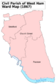
Stratford ward of West Ham Civil Parish in 1867.
-
Stratford Circus on Great Eastern Street.
See also
 In Spanish: Stratford (Londres) para niños
