
London Borough of Newham facts for kids
Quick facts for kids
London Borough of Newham
|
|||
|---|---|---|---|
|
|||
| Motto(s):
Progress with the People
|
|||

Newham shown within Greater London
|
|||
| Sovereign state | United Kingdom | ||
| Constituent country | England | ||
| Region | Inner London | ||
| Ceremonial county | Greater London | ||
| Created | 1 April 1965 | ||
| Admin HQ | East Ham | ||
| Government | |||
| • Type | London borough council | ||
| • Body | Newham London Borough Council | ||
| Area | |||
| • Total | 13.98 sq mi (36.22 km2) | ||
| Area rank | 298th (of 326) | ||
| Population
(2020)
|
|||
| • Total | 353,134 | ||
| • Rank | 20th (of 326) | ||
| • Density | 25,252/sq mi (9,749.7/km2) | ||
| Time zone | UTC (GMT) | ||
| • Summer (DST) | UTC+1 (BST) | ||
| Postcodes |
E, IG
|
||
| Area code(s) | 020 | ||
| ONS code | 00BB | ||
| GSS code | E09000025 | ||
| Police | Metropolitan Police | ||

The London Borough of Newham is a part of London called a borough. It was created in 1965. It brought together areas that used to be separate towns: West Ham and East Ham. The name "Newham" shows that it's a new place combining the old "Ham" areas.
Newham is in East London, about 8 kilometers (5 miles) east of the City of London. The River Thames is to its south, and the River Lea is to its west. It was one of the main places that hosted the 2012 Summer Olympics. You can find most of the Olympic Park here, including the London Stadium. London City Airport is also in Newham.
Some of the main areas within Newham include East Ham, West Ham, Stratford, Plaistow, Forest Gate, Beckton, and Canning Town. Newham has a population of about 387,576 people. This makes it one of the most populated boroughs in London. The local government is called Newham London Borough Council.
Contents
History of Newham
Newham was formed on April 1, 1965. It combined the areas of East Ham and West Ham. These places used to be separate towns in the county of Essex.
A small part of North Woolwich also joined Newham. This area was previously part of Woolwich, which was mostly south of the River Thames. The name Newham was chosen because it was a completely new name for the combined area.
How Newham Got Its Name
The area of Newham was once a large estate called 'Ham'. This name comes from an old English word meaning 'a dry area of land between rivers or marshland'. This describes the location well, as it's surrounded by the rivers Lea, Thames, and Roding.
The first time 'Hamme' was written down was in 958. By the 12th century, this large area was divided into smaller parts. These became the old parishes of West Ham, East Ham, and Little Ilford. The boundary between West Ham and East Ham was along Green Street.
Medieval Times in Newham
The area grew richer when Bow Bridge was built. This was the only bridge over the River Lea. The creation of Stratford Langthorne Abbey also helped the area to become more successful.
How Newham is Governed


The local government for Newham is called Newham Council. They meet at Newham Town Hall in East Ham. Their main offices are at 1000 Dockside Road, near the Royal Albert Dock. Since 2002, the council has been led by a Mayor who is chosen directly by the people.
People of Newham

Newham has a large population, with about 382,984 people living there in 2021. This makes it one of the most populated London boroughs. The population has grown since the 1980s.
Different Backgrounds in Newham


Newham has a very young population. It also has one of the lowest numbers of White British people in the country. About 32% of people in Newham are Muslim. This is the second highest percentage in the UK.
Newham is known for being very diverse, meaning people from many different backgrounds live there. In 2001, it was found to be the most ethnically diverse area in England and Wales.
As of 2021, the largest group of people are of "Bangladeshi" background, making up 15.9% of the population. "White British" people are the second largest group at 14.8%. Newham has a large Asian community, and many people from India, Pakistan, and Bangladesh live there.
Religious Beliefs in Newham

Religion in Newham as of 2021 Christianity (35.3%) Islam (34.8%) Irreligion (14.5%) Hindu (6.1%) Sikh (1.6%) Buddhist (0.6%) Jewish (0.1%) Other (7%)
The people of Newham follow many different religions. In 2021, the largest religious groups were Christians (35.3%) and Muslims (34.8%). Many people also reported having no religion (14.5%). Other religions include Hindu, Sikh, and Buddhist.
Education in Newham
Newham is the local education authority. It provides schooling through different types of schools. The borough also runs Debden House, a place for adults to learn. The Rosetta Art Centre in Stratford offers visual art courses. Essex Primary School is one of London's biggest primary schools.
Universities in Newham
The University of East London has two campuses in Newham. One is the Stratford Campus. The other is the Docklands Campus, next to the Royal Albert Dock.
Birkbeck, University of London also works with the University of East London. They offer adult learning courses at the University Square Stratford campus. The University of East London was a training base for the United States Olympic Team during the 2012 London Olympics.
Places to Visit in Newham
Community Centres
- The Hub is a community centre in Star Lane, E16. It was built by local people and has many "green" features.
- Grassroots is another community centre in Memorial Recreation Ground, E15. It also focuses on being environmentally friendly.
- Rosetta Art Centre is a visual art organisation near Grassroots in E15.
Libraries
Newham has ten libraries. These include libraries in Beckton, Canning Town, East Ham, and Stratford.
Museums
- Three Mills is a historic mill complex. The House Mill was built in 1776 and is the country's largest tide mill. It has been restored and you can see its old machinery.
Markets
Newham has several local markets. One famous market is Queens Market.
Parks and Green Spaces
Newham has many parks and open spaces. About 80 hectares of the borough are part of the Metropolitan Green Belt.
Performance Venues
- Stratford Circus Arts Centre offers theatre, dance, music, and comedy. They also work with schools to provide workshops.
- Theatre Royal Stratford East is a well-known theatre.
- St Mark's Church, Silvertown is now home to the Brick Lane Music Hall.
Shopping and Exhibitions
- Queen's Market is a historic street market.
- ICC London – ExCeL is a large international conference centre.
- Gallions Reach Shopping Park and Stratford Centre are popular shopping areas.
- East Shopping Centre is Europe's first shopping centre built for Asian boutiques.
- Green Street is a shopping street that mainly serves the Asian community.
- Westfield Shopping Centre, Stratford is one of the largest shopping centres in Europe.
Sports in Newham
- Newham was one of the six main areas that hosted the 2012 Summer Olympics.
- West Ham United F.C. football club plays its home games at the London Stadium in Stratford.
- The Newham and Essex Beagles Athletics Club is based at the London Marathon Community Track.
- Other football clubs like Clapton F.C., Clapton Community F.C., Athletic Newham F.C., and London APSA F.C. also play in Newham.
- The London Regatta Centre in Beckton promotes water sports like rowing.
Newspapers
The local newspaper for Newham is the Newham Recorder.
Areas of Newham

- Beckton
- Canning Town
- Custom House
- East Ham
- Forest Gate
- Manor Park
- North Woolwich
- Plaistow
- Silvertown
- Stratford
- Upton Park
- West Ham
Transport in Newham
Public transport in Newham has improved a lot since the 1980s.
The Docklands Light Railway (DLR) opened in 1987. It has been extended many times to serve places like London City Airport and Stratford International station. The Jubilee Line Extension was finished in 1999, adding new or better stations. The DLR helps make up for Newham not having many tube stations. The Elizabeth line (Crossrail) also improved train links across the borough. Most stations in Newham are easy to access for everyone.
Newham has one of only two airports within Greater London, London City Airport. It also has a high-speed rail station, Stratford International station, which is outside central London.
Train and DLR Stations
- Abbey Road DLR station
- Beckton DLR station
- Beckton Park DLR station
- Cyprus DLR station
- Canning Town station – Jubilee line and DLR
- Custom House station - Elizabeth line and DLR
- East Ham tube station – District and Hammersmith & City lines
- Forest Gate railway station – Elizabeth line
- Gallions Reach DLR station
- King George V DLR station
- London City Airport DLR station
- Manor Park railway station – Elizabeth line
- Maryland railway station – Elizabeth line
- Plaistow tube station – District and Hammersmith & City lines
- Pontoon Dock DLR station
- Prince Regent DLR station
- Royal Albert DLR station
- Royal Victoria DLR station
- Star Lane DLR station
- Stratford station – Abellio Greater Anglia, c2c, Elizabeth line, Jubilee and Central lines, London Overground and DLR
- Stratford High Street DLR station
- Stratford International station – Southeastern, DLR
- Pudding Mill Lane DLR station
- Upton Park tube station – District and Hammersmith & City lines
- Wanstead Park railway station – London Overground
- West Ham station – c2c, Jubilee, District and Hammersmith & City lines, and DLR
- West Silvertown DLR station
- Woodgrange Park railway station – London Overground
How People Travel to Work
In 2011, many Newham residents used public transport to get to work. About 23% used the underground, metro, or DLR. Around 7.6% drove a car or van, and another 7.6% used a bus.
River Services
- Woolwich Ferry
- Royal Wharf
Cable Car
- London Cable Car
International Connections
- London City Airport offers flights.
- The Dutchflyer rail-sea service can take you to the Netherlands from Stratford station.

Bus Routes
Over 30 London Buses bus routes serve Newham. Major bus stations are at Stratford, Stratford City, and Beckton.
Twin Towns
Newham is twinned with:
 Kaiserslautern, Germany
Newham's Coat of Arms
Newham uses a coat of arms that combines symbols from its past. The borough's motto is "Progress with the People". This means moving forward with the help of its residents.
The symbols on the coat of arms include:
- A crosier, which represents the Cistercian Stratford Langthorne Abbey.
- A sword and red and yellow patterns from the arms of William de Montfitchet. He was an important landowner and started the abbey.
- Crossed hammers, which stand for the Thames Ironworks and Shipbuilding Company. This was once a big employer in the area.
- A ship with full sails, showing the area's connection to the sea and trade.
- A sun rising in the east.
Special Honours
Some people and military groups have been given the Freedom of the Borough of Newham. This is a special honour.
Individuals Honoured
- Sir Jack Petchey: May 27, 2010.
- Mark Noble: December 15, 2016.
Military Units Honoured
- G Company 7th Battalion The Rifles: June 23, 2012.
Images for kids
-
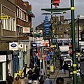
Green Street, a shopping area with a large South Asian community.

See also
 In Spanish: Newham para niños
