
Bow Back Rivers facts for kids
Quick facts for kids Bow Back Rivers |
|
|---|---|

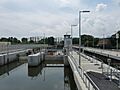
The sluices at Three Mills Lock, with the lock structure to the right
|
|
| Specifications | |
| Locks | 4 |
| Status | Open |
| Navigation authority | Canal and River Trust |
| Geography | |
| Connects to | Lee Navigation, River Lea, Bow Creek |
The Bow Back Rivers (also called Stratford Back Rivers) are a group of waterways in east London, England. They connect the River Lea to the River Thames. These rivers are found between the areas of Bow and Stratford.
People started working on these rivers in the 1100s. They wanted to drain the wet Stratford Marshes and use the water to power watermills. Some of the rivers in this system include Abbey Creek, Channelsea River, City Mill River, Prescott Channel, Pudding Mill River, Saint Thomas Creek, Three Mills Back River, Three Mills Wall River, and Waterworks River. Bow Creek is where these rivers finally flow into the Thames.
The river system used to be tidal, meaning the water level changed with the ocean tides, all the way up to Hackney Wick. This was good for tide mills, which used the rising and falling water to grind grain. Famous tide mills were at Abbey Mills and Three Mills. One of the Three Mills still stands today!
Over time, the rivers changed a lot. In 896, Alfred the Great even changed the river's path to trap some Danes. Around 1110, Queen Matilda paid for a bridge, now known as Bow Bridge, to cross both river channels.
In the 1600s, the New River was built to bring drinking water to London. This caused water levels in the Lea to drop. To keep boats moving, parts of the river were made deeper and wider, turning them into canals. Later, in 1767, the Lee Navigation was created. This led to new canals like the Hackney Cut and the Limehouse Cut. These new routes allowed barges to avoid most of the smaller back rivers.
A big project to rebuild the rivers happened in the 1930s to help with flood control. But by the 1960s, boats stopped using the rivers for business. The rivers became neglected and were seen as having no future.
However, in 2002, British Waterways decided to fully restore them. When the main stadium for the 2012 Summer Olympics was built on an island formed by these rivers, it brought money for new locks and sluices. These structures helped control water levels around the Olympic site. There were hopes that many building materials would arrive by boat, but this didn't happen much. Still, the rivers in the Olympic Park were greatly improved. They even had the biggest aquatic (water plant) planting project ever in Britain!
Contents
What are the Bow Back Rivers?
It's not clear exactly when these separate rivers started being called "Bow Back Rivers" as a group. In 1905, Charles Tween called them both "Stratford Back Rivers" and "Stratford Back Streams." Even in 1973, Powell still used the name "Stratford Back Rivers."
By the 1980s, the name "Bow Back Rivers" became more common. The river that feeds these waterways is called the River Lee or River Lea. Today, "Lea" usually refers to the natural river, while "Lee" refers to the canalized (made into a canal) part used for boats.
The name "Bow" might come from an arched bridge built over the River Lea in the 1100s. It could also come from a bend in the road east of Bow Road station.
A Look Back at History
The Bow Back Rivers flow through an area once known as Stratford Marsh. This was a common area where people could graze their animals for part of the year. It was also used to grow hay.
Long ago, there was a stone path across the marsh. An old crossing point called Old Ford was used even before the Romans arrived. It was part of a route from London to Essex.
The River Lea was once wide and fast-flowing. It was tidal all the way up to Hackney Wick. Boats could travel far up the river into Hertfordshire. We don't know exactly when boats first used these rivers. But ancient canoes and Saxon barges have been found in the marshes.
In 896, Alfred the Great may have dug a new channel. This trapped a group of Danes and lowered the tide level. This made it harder for large boats to use the river until the 1400s.
Around 1100, King Henry I's wife, Queen Matilda, paid for a new road and two bridges. One bridge crossed the Lea, and the other crossed the Channelsea River. The place where the bridge was built became known as Stratford-atte-Boghe, which later became Bow. The word "Bow" likely came from the arched shape of the bridge, which was a new style for the time.
In 1135, Stratford Langthorne Abbey was built. The Abbey helped drain the marsh and create artificial channels. These channels were used to power water and tide mills. A small river port grew at Stratford to serve the Abbey and the mills. The Abbey was also in charge of keeping the marsh walls strong around Bow Creek to stop the tides.
By 1571, the river was used to transport goods and people. An Act of Parliament (a special law) was passed to improve the river. This was to make sure grain could still reach London. A new section of river was dug, and a pound lock was built at Waltham Abbey. This was only the second one ever built in England.
There were three other bridges between Bow Bridge and Channelsea Bridge. These were built because mill streams had cut through Queen Matilda's causeway. The mill owners were responsible for these bridges. Today, all three have been replaced by Groves Bridge, built in 1933.
The Northern Outfall Sewer crosses the Back Rivers on low bridges. This sewer leads to the Abbey Mills Pumping Station. Both were designed by Joseph Bazalgette in the 1860s. Today, you can walk along a public path called The Greenway on top of the sewer's embankment.
Water for London
Water was taken from these rivers to supply London. In 1633, the New River opened. This was a 40-mile (64 km) channel bringing water from springs to London. This reduced the water levels in the Lea, affecting both boat travel and mills.
Around 1745, the West Ham Waterworks Company built a waterworks at Saynes Mill. The river there later became known as Waterworks River. The East London Waterworks Company also built works at Old Ford in 1807. They later moved their water source upstream and built a canal in 1830 to get water from Lea Bridge.
The Waterworks River changed a lot over the years. It was once called Lead Mills Stream further north. Over time, sections were filled in or changed, and its connection to the Old River Lee moved.
Boats and Canals
The River Lee was navigable (boats could travel on it) up to Hertford. But it used flash locks, which were simple gates that caused problems for millers. When a flash lock was opened, the water level above it dropped, making it hard for mills to work.
In 1765, engineer John Smeaton was asked to improve the river. He suggested replacing the flash locks with modern locks that have two gates. He also suggested new cuts (canals) to make travel easier. These became the Hackney Cut and the Limehouse Cut.
The Limehouse Cut opened in 1770, giving direct access to the River Thames and avoiding the tidal Bow Creek. It was later made wider because it was too narrow for barges to pass each other. The Hackney Cut opened in 1769.
At first, there were no tolls (fees) for using Bow Creek or the Bow Back Rivers. But in 1850, a law allowed a lock to be built at Bow tidal gates, and a toll was charged. This was not popular.
By 1821, Stratford had many wharves (docks) for different goods like timber, coal, and wheat. Some factories and mills had their own private wharves. A large dock called Stratford Dock (later Meggs Dock) was built near Bow Bridge. However, it was filled in by 1920.
In the 1860s, income from the river dropped because of competition from railways. Even so, improvements continued. Old Ford Lock was built to handle larger 100-ton barges. The people in charge of the River Lee were also responsible for the Bow Back Rivers. But since these rivers didn't make money, they weren't well maintained. They couldn't be closed, though, because they helped drain excess water from the upper river to prevent flooding.
Making the Rivers Better
By the 1920s, the rivers were in poor condition. With many people out of work, the local government and the Lee Conservancy Board got money to make big improvements. They duplicated Bow Tidal Lock, rebuilt Marshgate Lock as City Mill Lock, and built a new lock at Carpenters Road. This new lock had special up-and-over radial gates.
A law called the River Lee (Flood Relief) Act was passed in 1930, and work began in 1931, finishing in 1935. As part of this work, the City Mill River was made 50 feet (15 m) wide. The Three Mills Wall River and Waterworks River were made twice as wide.

The 1930s improvements also included the Prescott Channel. This channel was built to let floodwater bypass the Three Mills tide mills. It had sluices (gates) to control water levels, but these stopped working when the tide mills closed.
By the 1960s, only a few of the rivers were still used for business. As boat traffic stopped, the locks fell apart. By 2006, City Mills Lock and Carpenters Road Lock were not used. In 1968, most of the Bow Back Rivers were put into a category for waterways with no economic future. They were neglected until 2002, when British Waterways decided to fully restore them.
The Olympics and the Rivers

The Olympic Stadium for the London 2012 Summer Olympics was built on land between the Lea Navigation and the City Mill River. Part of the Pudding Mill River was filled in to make space for the stadium.
To help with construction, Three Mills Lock was built on the Prescott Channel. This lock is big enough for 350-ton barges. It also has a sluice to control water levels, so boats don't have to wait for the tides. The lock cost £23 million and was finished in 2009. While it was hoped that many building materials would be moved by boat, very little commercial traffic used the new lock.
With stable water levels, City Mills Lock was repaired for £400,000. It had not been used for about 40 years. It was reopened for public use on July 31, 2010. There were plans to restore Carpenters Road Lock after the Olympics. Temporary bridges were built over the lock area for the games.
The Olympic Delivery Authority decided to cover up (culvert) more of the Channelsea River in the northern part of the site. They worked with the Environment Agency to manage flood risks and create new habitats to make up for the lost ones.
Before the Olympics, much of the old River Lea was not open to the public. Now, it's a main feature of the new parklands. Two "wetland bowls" were designed and planted with water-loving plants like reeds, rushes, sedges, and iris. These areas also help fish spawn and provide storage for floodwater. This was the largest aquatic planting project ever in Britain, with 350,000 plants grown from seeds and cuttings from the site.
At the southern end of the site, the Waterworks River was rebuilt. Its old concrete sides were replaced with wider, sloping banks. These new banks were planted with water plants, making the river look better and be better for wildlife.
After the Olympics, access to the waterways was limited. The rebuilding of Carpenters Road Lock was delayed. However, the £1.8 million project to rebuild it was almost finished by May 2017. New radial gates were put in place. The Heritage Lottery Fund gave £680,000 towards the cost. These gates can act as a lock for boats and also help control water levels for flood prevention. Public access to the waterways around the Olympic Stadium was also planned to open in June or July 2017.
Locks on the Rivers
The locks on the Bow Back Rivers are not all the same size. Here's a table showing some of them:
| Lock | Type | Length | Width | Notes |
|---|---|---|---|---|
| Bow Tidal | twin | 93.5 ft (28.5 m) | 20 ft (6.1 m) | Built 1900 and 1931 |
| Carpenters Road | single | 92 ft (28 m) | 20 ft (6.1 m) | Built 1933, has rising radial gates, reopened 2017 |
| City Mills | single | 95 ft (29 m) | 20 ft (6.1 m) | Built 1933, reopened 2010 |
| Marshgate | single | Built 1864, removed 1935 | ||
| Old Ford | twin | 90 ft (27 m) | 18.5 ft (5.6 m) | Built 1902 and 1935 |
| Three Mills | single | 203 ft (62 m) | 26 ft (7.9 m) | Built 2009, has hydraulic sector gates |
Images for kids
-

Old Ford, end of Old River Lea
-
Three Mills Lock

