
Bow Creek (London) facts for kids
Quick facts for kids Bow Creek |
|
|---|---|

Bow Creek (tidal) (far left) meets the Limehouse Cut (canal, right), at Bow Locks on the Lee Navigation (centre); with a view of London's Docklands
|
|
| Country | England |
| Physical characteristics | |
| Main source | Confluence of Prescott Channel and Channelsea River at Bow Locks |
| River mouth | River Thames, Leamouth |
| Length | 2.25 miles (3.6 km) |

.jpg)
Bow Creek is a 2.25-mile (3.6 km) long tidal river in East London. It's actually the last part of the River Lea before it joins the River Thames. Bow Creek is also part of the Bow Back Rivers system. Below a place called Bow Locks, the creek forms the border between two London areas: Newham and Tower Hamlets.

Contents
The Story of Bow Creek
The River Lea starts far away in Luton, Bedfordshire. It flows east and then south, eventually reaching the River Thames at a spot called Leamouth. The last 2.25 miles (3.6 km) of this journey are known as Bow Creek. This part of the river winds its way through an area that used to be a marsh. Today, you'll find gas works and business parks there. The River Lea is one of the oldest waterways used for boats in the country. However, Bow Creek is tidal, meaning the water level changes a lot with the ocean tides. This makes it too shallow for boats at low tide.
Early River Travel and Improvements
People have been using the River Lea for travel and transport since at least 1190. In 1424, it became the first river in Britain to get official permission from Parliament for improvements. This meant people could start making the river better for boats.
Later, in 1571, the Lord Mayor of London was allowed to make new cuts (channels) and improve the river. They also built paths on both sides for horses to pull barges. It's thought that a new channel was dug between Old Ford and Bow Locks around this time. This channel is called Bow River, and like Bow Creek, it didn't charge tolls for boats to use it.
During the terrible Great Plague in 1665, boatmen on the river were heroes. They kept bringing food to the people of London. Because of their bravery, they were allowed to use the Thames without needing help from a special Lighterman (a person who helps guide boats). This was a big deal and showed how important they were.
Making the River Better for Boats
In 1765, a famous engineer named John Smeaton was asked to study the river. He needed to figure out how to make it even better for boats. In 1766, he suggested replacing old-fashioned "flash locks" with newer, more efficient "pound locks".
More importantly for Bow Creek, Smeaton suggested digging a new channel. This channel would go from the tidal gates at Bow directly to the Thames at Limehouse. This new route was a bit further west, but it saved boats a long trip around the Isle of Dogs if they were heading towards London.
The new channel was supposed to open in July 1770. But a wall collapsed, so it was delayed until September. Then, a bridge fell into it in December! Even with these problems, boats started using the new channel. It was too narrow for two barges to pass, so it had to be widened. This work finished in 1777. This channel now ends in a place called Limehouse Basin.
Controlling the Water: Bow Locks
Boats still entered the main navigation, now called the Lee Navigation, through tidal gates at Bow. There have been gates here since at least 1307! They were rebuilt many times over the centuries. In 1588, records suggest the gates would open by themselves when the incoming tide reached the same level as the river inside.
Even though Smeaton suggested building a proper lock in 1766, it wasn't done then. However, in 1852, a lock was finally built, though the old gates stayed too. The lock was rebuilt and made shorter in 1900. Then, a second lock was added next to it in 1931. In 2000, taller floodgates and walls were added. These stop the Lee Navigation from flooding when the tide in Bow Creek gets very high.
Connecting to Other Waterways
In the 1930s, the ways boats could get from Bow Creek to the Bow Back Rivers were changed. This was part of a big project to improve the waterways and create jobs. The Prescott Channel was built to go around the old tide mills. This new channel connected the creek to the Three Mills Wall River and the Waterworks River.
The lock and sluice (a gate to control water flow) at the start of this new channel stopped being used in the 1960s and were removed. But for the 2012 Summer Olympics, a new structure was built. It's big enough for barges weighing 350 tonnes! This reconnected Bow Creek to the Bow Back Rivers, making them navigable again.
Bow Creek also used to connect to Abbey Creek and the Channelsea River, which led to an old part of the River Lea near Hackney Marshes. Most of this waterway is now covered over. Water also flowed into the creek from the sluices of the tide mills at Three Mills.
Ships and Bridges
Ships were built at a place called the Orchard House Yard, near the southern end of Bow Creek at Leamouth. Once built, they were launched into the creek. From there, they could travel north along the River Lee Navigation or south to the River Thames. In 1810, an iron bridge was built across the creek, just south of where the modern A13 road bridge is today. The parts of that old bridge are now used for the pedestrian Jubilee Bridge.
Images for kids
-
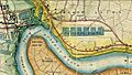
Map c1872, showing Victoria Docks, now Royal Victoria Dock, Bow Creek and the Thames Ironworks and Shipbuilding Company
-
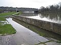
Bow Creek flooding at high tide
-

Bow Creek at high tide with a view towards Balfron Tower and Canary Wharf
