
Walthamstow facts for kids
Quick facts for kids Walthamstow |
|
|---|---|
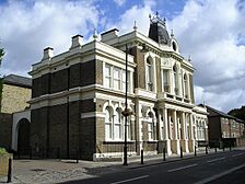
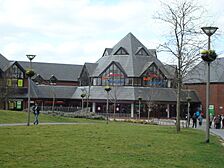
_-_2022-10-01.jpg)   Clockwise from top: Waltham Forest Town Hall, Walthamstow Library, and the William Morris Gallery
|
|

Walthamstow
|
|
| Population | 109,424 (2011 Census) |
| OS grid reference | TQ372891 |
| • Charing Cross | 7.5 mi (12.1 km) SW |
| London borough | |
| Ceremonial county | Greater London |
| Region | |
| Country | England |
| Sovereign state | United Kingdom |
| Post town | LONDON |
| Postcode district | E17 |
| Dialling code | 020 |
| Police | Metropolitan |
| Fire | London |
| Ambulance | London |
| EU Parliament | London |
| UK Parliament |
|
| London Assembly |
|
Walthamstow is a town in the London Borough of Waltham Forest. It is about 12 kilometers (7.5 miles) north-east of Central London. The town is next to Chingford in the north, Snaresbrook and South Woodford in the east, Leyton and Leytonstone in the south, and Tottenham in the west. In 2011, about 109,424 people lived here.
Walthamstow is home to Walthamstow Market, which is the longest outdoor market in Europe. It runs along most of the High Street. To the east, you'll find Walthamstow Village, the oldest part of the town. This is where St Mary's Church, the town's main church, is located.
In the north of Walthamstow, there used to be the Walthamstow Stadium. It was a famous landmark in the East End. The William Morris Gallery on Forest Road is a museum. It used to be the home of the famous artist and designer William Morris. The town has five railway stations, including Walthamstow Central and Blackhorse Road. These stations connect to the Victoria line of the London Underground.
Walthamstow was once a small village in Essex. It grew very quickly in the 1800s as London expanded. It became part of Greater London in 1965. This happened when it joined with Chingford and Leyton to form the new Waltham Forest area. The local council, Waltham Forest London Borough Council, is based at Waltham Forest Town Hall.
Contents
History of Walthamstow
What's in a Name?
The name Walthamstow comes from old words. Around 1075, it was called Wilcumestowe, which means "the Place of Welcome." In 1086, it was written as Wilcumestou in the Domesday Book.
Walthamstow's Early Days

The Domesday Book shows that a nobleman named Earl Waltheof owned Walthamstow before 1066. After he died, his wife, Countess Judith, took over the land. She was a niece of William the Conqueror. In 1086, the Domesday Book recorded 65 people living in the area.
Later, Alice, the daughter of Earl Waltheof and Countess Judith, inherited Walthamstow. She married a Norman nobleman named Ralph de Tosny. Around 1126, Alice gave the Walthamstow church to the Priors of the Holy Trinity in London.
King John even stayed in Walthamstow for two nights in February 1208.
In the 1660s, Sir William Batten, who worked for the Navy, lived in a large house in Wood Street. He lived "like a prince" and even had a vineyard. The Vestry House, which is now the Vestry House Museum, was the first building used as a town hall.
The famous textile designer William Morris was born in Walthamstow in 1834. The old house where he lived as a teenager is now the William Morris Gallery. By 1870, Walthamstow had grown into a small suburb. A new town hall was built in Orford Road to manage the village. A much newer town hall, designed by Philip Dalton Hepworth, was built between 1938 and 1942.
How Walthamstow Grew
Until the late 1800s, Walthamstow was mostly countryside. It had a small village center, now called Walthamstow Village, and some large estates. The main road was Hoe Street. Other smaller roads crossed the town. Forest Road was once called Clay Street. The High Street was called Marsh Street and led to the Walthamstow Marshes. Shernhall Street and Wood Street are also very old roads.
When the railways arrived in the late 1800s, Walthamstow's population grew a lot. Many new houses were built.
The Lighthouse Methodist Church, built in 1893, is on Markhouse Road. It has a lantern at the top of its tower. A shipbuilder named Captain David King helped pay for the church.
Big Steps in Transport
.jpg)
In 1885, John Kemp Starley from Walthamstow designed the first modern bicycle. In 1892, Frederick Bremer built the first British motorcar in his garden workshop. You can see this car at the Vestry House Museum.
London's famous buses, like the LGOC X-type and B-type, were built at Blackhorse Lane starting in 1908. The B-type is thought to be one of the first buses made in large numbers. This factory later became AEC, which made many of London's buses.
On June 13, 1909, A. V. Roe's aircraft flew from Walthamstow Marshes. It was the first all-British airplane. Roe later started the Avro aircraft company, which built the famous Avro Lancaster bomber.
Walthamstow Power Station
Walthamstow had its own power station on Exeter Street. It started supplying electricity in 1904. In 1948, the government took over the electricity industry. The power station closed in 1967 and was later taken down.
Walthamstow Today

Since the 2012 Summer Olympics, Walthamstow has become very popular. House prices went up a lot from 2013 to 2014. This has made Walthamstow a "trendy" place, like Shoreditch. The pretty Walthamstow Village is especially popular.
In 2015, a unicyclist was hit by a bus on Hoe Street. About 100 local people helped pull the bus off the unicyclist. The local MP, Stella Creasy, said she was "proud" of the community for saving his life.
Walthamstow's Location and Areas

.jpg)

Walthamstow is surrounded by other towns. Chingford is to the north, and Leyton and Leytonstone are to the south. Woodford is to the east, near Epping Forest. Hackney is to the south-west, across the Walthamstow Marshes. Tottenham is to the west, across the River Lea. The A112 road goes through Walthamstow and its nearby towns. This road is part of an old route from London to Waltham Abbey. Walthamstow is south of the North Circular Road. Walthamstow Central is the main transport hub.
Walthamstow Village is a special area to the east of the main shopping center. It has quiet streets, unique shops, pubs, and restaurants. House prices are often higher here. In 2004, Time Out magazine called it the best urban village in London.
Upper Walthamstow is east of Walthamstow Village. Its main street is Wood Street, which has many shops. It has its own station, Wood Street station, on the London Overground line.
One of the Great Trees of London, the Wood Street Horse Chestnut, is next to the old Jones's Butchers Shop. This shop is a very old building from the late 1700s. The tree is thought to be over 175 years old.
Wood Street is also home to the Wood Street Indoor Market. This market used to be a cinema. Now, it is full of unique market stalls.
Walthamstow has many different types of houses. Most homes were built in the early 1900s. You can find thousands of terraced streets from the Edwardian era and the 1920s. Some areas have more modern housing built after Second World War bombing raids.
The area around Blackhorse Road is being developed. It is planned to become a new entrance to the town.
Even though it's near the marshes and parts of Epping Forest, Walthamstow itself doesn't have many large open spaces. There used to be two common lands, Church Common and Markhouse Common, but they were sold in the 1800s. Lloyd Park has been open to the public since 1900. It is behind the William Morris Gallery. It has a garden, a pond, and areas for sports like bowling, tennis, and basketball. It also has a skate park and a children's play area.
Walthamstow's People
Walthamstow is made up of seven voting areas within the London Borough of Waltham Forest. In the 2011 census, the total population of these areas was 109,424.
The largest group of people in all areas is White British. Other White people are the second largest group in most areas. Other big groups include Pakistani and Black African people. The number of people from minority ethnic backgrounds ranges from 48.5% to 58.2%.
Life expectancy for men ranged from 77.2 to 82.1 years. For women, it ranged from 82.1 to 84.8 years. These numbers are from 2009 to 2013.
Walthamstow's Economy
.jpg)
The High Street is famous for Walthamstow Market, which started in 1885. It is about two-thirds of a mile long, making it the longest street market in Europe. The market is open five days a week (not Sunday or Monday). There is also a Sunday farmers' market. The street has many shops, including big chains and small independent stores selling food, fabrics, and household goods.
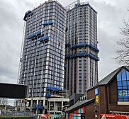
There are also two newer shopping areas. One is a Sainsbury's supermarket. The other is the 17&Central shopping center, which was damaged by a fire in 2019 but has been fully repaired. Both have large car parks.
The historic central library on the High Street was built with money from Andrew Carnegie, a Scottish-American businessman. His statue is on the outside of the building. The library was damaged by fire in 1982 but was updated in 2006–07.
A new cinema, flats, and restaurants were built on a large plot at the corner of High Street and Hoe Street. This project started in 2013 and finished in 2014. In 2024, the town square is being updated, and new homes are being built near the 17&Central shopping center.
The Walthamstow Beer Mile, also called the Blackhorse Beer Mile, is a popular place. It has many small breweries and their tap-rooms around Blackhorse Road.
Getting Around Walthamstow

Trains and Underground
Walthamstow has trains on the London Underground, London Overground, and National Rail networks.
Walthamstow Central is the busiest station. It is the end of the London Underground Victoria line. This line connects Walthamstow directly to Tottenham, the West End, and Brixton. The station also has London Overground trains that go between London Liverpool Street and Chingford.
You can walk from Walthamstow Central to Walthamstow Queen's Road. This station is on the London Overground line between Gospel Oak and Barking.
Blackhorse Road is in the west of Walthamstow. It also has Victoria line trains and London Overground trains.
Other stations include St James Street and Wood Street. These are on the London Overground line between Liverpool Street and Chingford.
Lea Bridge is also nearby. It has trains that go between Stratford and Bishop's Stortford.
All stations in Walthamstow are in London fare zone 3, except Wood Street, which is in zone 4.
Buses
Many London Buses routes serve Walthamstow. These include routes 20, 34, 55, 58, 69, 97, 123, 158, 212, 215, 230, 257, 275, 357, 675, SL1, SL2, W11, W12, W15, W16, W19. There are also night bus routes N26, N38, and N73.
Walthamstow bus station is next to Walthamstow Central station.
Roads
Several main roads go through Walthamstow. These roads connect the area to other parts of London and the East of England.
To the north, the A406 (North Circular) goes east and west around Walthamstow. This road connects to Ilford, the M11 (for Stansted Airport), and London City Airport to the east. To the west, it goes through Edmonton and Finchley.
To the southeast, the A12 goes northeast towards the M25 and places in Essex. To the southwest, the A12 goes around Stratford and Hackney Wick.
Other important roads include:
- A104 (Lea Bridge Road) – goes southwest to Lea Bridge and northeast to Epping Forest.
- A112 (Hoe Street/Chingford Road) – goes south to Leyton and north to Chingford.
- A503 (Forest Road) – goes east and west through Walthamstow.
Cycling
Transport for London (TfL) and the London Borough of Waltham Forest have built cycling paths in Walthamstow. In 2014, about 8.41% of traffic in the area was cyclists. In the same year, the area received a "Mini Holland" grant to improve cycling routes.
Cycling routes include:
- Quietway 2 – starts at Walthamstow Central and goes through quiet streets to Bloomsbury.
- Lea Bridge Road Cycle Route – goes from Leytonstone to Clapton with a separate cycle track.
- Forest Road Cycle Route – goes from Walthamstow to Tottenham with cycle lanes.
The River Lea towpath is also nearby. It's a traffic-free path for cycling from Walthamstow Marshes to Hackney Wick and Stratford in the south. To the north, it goes to Tottenham Hale and Hertford. This path is also part of National Cycle Route 1 (NCR 1).
Modern Culture in Walthamstow
- The popular 1990s boy band East 17 was from Walthamstow. They named themselves after the area's postcode, E17, and their first album was called Walthamstow.
- The album cover for Blur's Parklife album has photos of the band at Walthamstow Stadium.
- Singer Jimmy Ray grew up in Walthamstow and performed in local bands. He later had solo hits.
- Walthamstow is a big center for grime music. Artists like Lethal Bizzle are from here.
- The song "Poppy Bird" by Bromheads Jacket mentions Walthamstow.
- Small Wonder Records was on Hoe Street in the late 1970s and early 1980s. It released early records by bands like The Cure and Cockney Rejects.
- The Paul McCartney and Wings song "Old Siam, Sir" mentions Walthamstow.
- The song "Ann and Joe" by The Barron Knights starts with "Long ago, outside a chip shop in Walthamstow."
- "Waiting in Walthamstow" is a song by The Cranberries.
- The Genesis song "Battle of Epping Forest" has lyrics about the area.
- The indie rock band The Rifles and the rock band The Bevis Frond are from Walthamstow.
- The TV show Educating the East End was filmed at Frederick Bremer School in Walthamstow in 2013-2014.
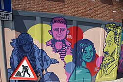
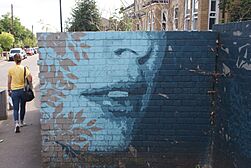
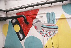
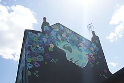
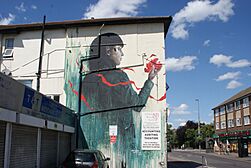
Street Art
Walthamstow has many street art and murals on public buildings. This is partly because of its connection to William Morris and art. Here are some examples:
-
Hawthorne Road
-
Chingford Road
-
West Avenue
-
Hoe Street
-
Wood Street
-
Wood Street
-
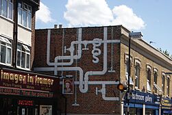
Wood Street
.jpg)


Cinema
An early British film studio, the Walthamstow Studios, operated here between 1914 and 1930.
The EMD (Granada) Walthamstow (once called the Granada) is a Grade II listed cinema building on Hoe Street. This cinema also hosted live music concerts by famous bands like The Beatles and The Rolling Stones. It closed in 2003.
Many local people did not want the building to become a church. Famous people like Griff Rhys Jones and Paul McGann supported the local residents.
The local council and the Secretary of State did not allow the building to be changed into a church. In 2014, a pub company bought the building and opened a bar in the main hall. In 2019, Waltham Forest Council bought the main cinema area. They plan to open it as an entertainment venue.
A new multiplex cinema, Empire cinema, opened in December 2014 on Walthamstow market. It closed in July 2023. The cinema was badly damaged during an illegal event in September 2023.
Sports Clubs
Walthamstow is home to several sports clubs:
- Walthamstow F.C. (football)
- Walthamstow Avenue F.C. (a former football club)
- Walthamstow Avenue & Pennant (sports club)
- Waltham Forest Hockey Club (hockey)
- Haringey & Waltham Development F.C. (football)
- Walthamstow Cricket Club (cricket)
Education in Walthamstow

Walthamstow has several secondary schools:
- Frederick Bremer School
- Forest School
- Holy Family Catholic School
- Kelmscott School
- Walthamstow Academy
- Walthamstow School for Girls
- Willowfield School
For older students, there are also:
- Big Creative Academy
- Sir George Monoux College
- Waltham Forest College
Media
Local news is provided by the East London & West Essex Guardian. The BBC Three TV show Him & Her was filmed in Walthamstow.
Famous People from Walthamstow
One of the most famous people from Walthamstow was William Morris. He was a writer, poet, designer, and socialist. He was born here on March 24, 1834. His old house in Walthamstow is now a museum about his life and work. The gardens of his house are now Lloyd Park, a public park.
- Naomi Ackie, actress
- Keith Albarn, manager of Soft Machine
- Sonita Alleyne, Master of Jesus College, Cambridge
- Clement Attlee, former Prime Minister
- Sir William Batten, Surveyor of the Navy
- Stephen Bear, reality TV star
- Steve Bell (cartoonist), cartoonist
- Alonza Bevan, bass guitarist of Kula Shaker
- Lethal Bizzle, Rap/Grime artist
- Peter Blake, artist
- Leonard Borwick, concert pianist
- Matthew Bourne, choreographer and dancer
- Mick Box, guitarist for Uriah Heep
- Theodore Ronald Brailey, pianist on the RMS Titanic
- Frederick Bremer, engineer and inventor
- David Cairns, guitarist with Secret Affair
- Alexander Champion, founder of British whaling
- Phil Collen, lead guitarist of Def Leppard
- Stella Creasy, Labour MP
- Iain Dale, broadcaster
- Sir John Dankworth, jazz musician
- Christopher Martin Davis, ice dancer
- Paul Di'Anno, lead singer of Iron Maiden
- Adam Devlin, guitarist for the Bluetones
- Benjamin Disraeli, former British Prime Minister
- Ian Dury, singer and songwriter
- Fleur East, singer
- East 17, pop boy band
- Sir George Edwards, designer of Concorde
- Mabel Elliott, British censor
- Joe Ellis-Grewal, cricketer
- Lucian Ercolani, founder of furniture company Ercol
- Jody Fleisch, professional wrestler
- Nick Gentry, portrait artist
- Air Marshal Sir Kenneth Charles Michael Giddings
- Thomas Field Gibson, manufacturer
- Maurice Glasman, social theorist
- Eleanor Graham, book editor and author
- Peter Greenaway, film director
- Daisy Greville, Countess of Warwick, noblewoman
- Fitz Hall, retired footballer
- Darren Hayman, singer and songwriter
- Lord Peter Hennessy of Nympsfield, historian and author
- James Hilton, author
- Helen Hollick, writer
- Mick Hume, journalist
- Countess Judith, noblewoman
- Harry Kane, footballer
- Colin Kazim-Richards, footballer
- Jane Lomax-Smith, Australian politician
- Agnes Marshall, culinary entrepreneur
- Sir George Monoux, Lord Mayor of London
- William Morris, designer, socialist and artist
- Fabrice Muamba, footballer
- Lutalo Muhammad, taekwondo athlete
- Denis Payton, saxophonist for the Dave Clark Five
- Grayson Perry, ceramicist and artist
- Pascale Petit, poet
- Ernie Phypers, professional footballer
- Fred Pontin, holiday camp owner
- Jimmy Ray, recording artist
- Danny Robins, comedy writer and broadcaster
- Ken Russell, film director
- Nick Saloman, progressive rock musician
- June Sarpong, television presenter
- Baroness Scotland, Attorney General
- Vivian Stanshall, musician and writer
- John Kemp Starley, inventor
- Colin Stinton, actor
- Beryl Swain, motorcycle racer
- Thomas Griffith Taylor, Antarctic explorer
- Ron Todd, trade union leader
- Lawrence Trent, international chess master
- Leicester Tunks, operatic baritone and actor
- Nicola Walker, actor
- Peter Waterfield, Olympic diver
- Dorothy Wedderburn, college principal
- Geoffrey Wellum, RAF fighter pilot
- Danniella Westbrook, actress
- Sir Sir Robert Wigram, shipbuilder and MP
- Timothy Williams, novelist
- Peter Winch, philosopher
- Eric Wolf, Marxist anthropologist
- Adam Woodyatt, English actor
- Mina Zdravkova, ice dancer
Images for kids
-
Old Town Hall, Walthamstow, now Yiguandao UK headquarters
-
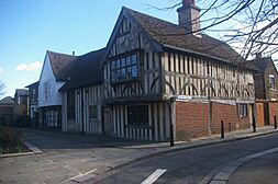
15th century "Ancient House" in Walthamstow village
-
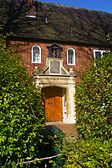
Monoux Almshouses in the village
-
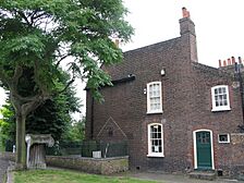
Vestry House Museum
-
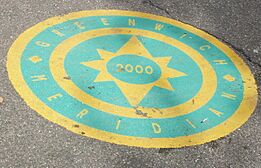
Longitude zero marker in Upper Walthamstow Road
-
The 17&Central Shopping Centre before construction work in 2010
-
New homes under construction adjacent to the 17&Central shopping centre in 2024
-
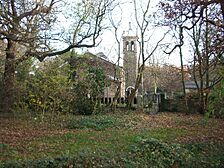
St Peter-in-the-Forest church, near Woodford New Road in the southern edge of Epping Forest
-
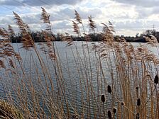
Walthamstow Reservoir
-
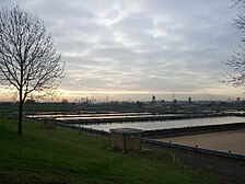
The filter beds at Coppermills Treatment Works


See also
 In Spanish: Walthamstow para niños
