Hackney, London facts for kids
Quick facts for kids Hackney |
|
|---|---|
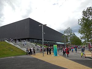 The Copper Box Arena, in the Queen Elizabeth Olympic Park |
|
| Population | 77,736 (2011 census) |
| OS grid reference | TQ347845 |
| • Charing Cross | 4 mi (6.4 km) SW |
| London borough | |
| Ceremonial county | Greater London |
| Region | |
| Country | England |
| Sovereign state | United Kingdom |
| Post town | LONDON |
| Postcode district | E5, E8, E9, E20, N1, N16 |
| Dialling code | 020 |
| Police | Metropolitan |
| Fire | London |
| Ambulance | London |
| EU Parliament | London |
| UK Parliament |
|
| London Assembly |
|
Hackney is a lively area in East London, England. It's about 4 miles (6.4 km) northeast of central London. Hackney is a big part of the London Borough of Hackney, which is named after it. It even includes a piece of the famous Queen Elizabeth Olympic Park!
In the past, people sometimes called it Hackney Proper. This helped tell it apart from a smaller village that grew up nearby. Hackney is a large district. Its old boundaries include areas like Homerton, Dalston, De Beauvoir Town, Upper and Lower Clapton, Stamford Hill, Hackney Central, Hackney Wick, South Hackney and West Hackney.
Contents
How Hackney is Governed
For many centuries, Hackney was a single administrative area. It was based on the old Ancient Parish of Hackney. This was the largest parish in Middlesex.
Hackney was once part of a much larger area called the Manor of Stepney. Its church was first recorded around 1275. This suggests Hackney might have become its own parish by then.
Historically, Hackney was part of the county of Middlesex. However, many local duties were handled by the Tower Division. This group was led by the Constable of the Tower of London. This special arrangement lasted until 1900.
Over time, the way areas were governed changed. In 1855, Hackney and Stoke Newington were joined together. But this didn't work out well. The two areas didn't get along. So, in 1893, they became separate again.
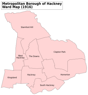
In 1899, these parishes became Metropolitan Boroughs. Hackney became the Metropolitan Borough of Hackney. Then, in 1965, Hackney joined with Shoreditch and Stoke Newington. Together, they formed the new London Borough of Hackney that we know today.
A small part of Victoria Park used to be in Hackney. But in 1994, the boundary changed. Now, the whole park is managed by the Tower Hamlets.
What's in a Name?
The name Hackney first appeared in records as Hakney (1231) and Hakeneye (1242). The name comes from Old English. Its exact meaning is not fully known. However, the 'ey' part likely means an island or a dry area in marshy land. An 'island' here could also mean land between two streams.
This 'island' might have been near the River Lea. Or perhaps it was close to where the Hackney Brook and Pigwell Brook met in the Hackney Central area.
Experts think Hackney might mean 'Haka's island'. Haka was likely an important local person. Other ideas for the 'Hack' part include:
- 'Haecc', meaning a gate to a woodland.
- 'Haca', meaning a hook, like a bend in a river.
- Some even think 'Hack' means 'woodpecker'.
Hackney's History
Early Settlements
Hackney is mostly flat and close to two rivers, the Lea and the Hackney Brook. This made it a good place for farming. People likely cleared forests here very early on. We have archaeological proof of farming and settlements from the Stone Age.
During the late Iron Age, the powerful Catuvellauni tribe lived in this area.
Roman Times
Before the Romans arrived in 43 AD, Hackney had local roads. Because it was near Londinium (Roman London), two major Roman roads soon crossed Hackney. One was Ermine Street (modern A10), which went north. The other branched off and crossed Hackney towards Great Dunmow in Essex.
Three Roman sarcophagus burials have been found in Hackney. These are stone coffins. One was made of marble, which suggests important people lived here.
Anglo-Saxon Era
The name Hackney is Old English, so it probably came about during this time. Hackney was part of the Middle Saxons' land. This area was part of the huge Manor of Stepney, owned by the Bishop of London.
Later, Hackney became part of the shire of Middlesex. This was when the Kings of Wessex were uniting England.
After the Norman Conquest
After winning the Battle of Hastings in 1066, the Normans secured London. The Domesday Book of 1086 recorded land at a manor level. So Hackney was listed as part of the Manor of Stepney.
At this time, Hackney was mostly farmland. There were also woodlands, but these decreased as the population grew.
Tudor and Later Growth
From the Tudor period onwards, Hackney's small settlements grew. Wealthy Londoners moved here. They liked the pleasant countryside, which was still close to the capital. It was a bit like a modern commuter town.
Many royal courtiers lived in Homerton. Henry VIII had a palace at Brooke House in Upper Clapton. Queen Mary even took an important oath there. Sutton House, built in 1535, is the oldest surviving home in the area.
Becoming a City
The main 'Hackney Village' became much larger than other nearby areas. By 1605, it had as many houses as Dalston, Newington, Kingsland and Shacklewell combined.
In 1727, writer Daniel Defoe noted how much Hackney had grown. He said its small villages had "encreas'd in buildings, and so fully inhabited". He added that Hackney was becoming "a part of" London, even though it didn't directly touch the city.
In the 1770s, Hackney became home to a famous plant nursery. Loddiges Paradise Field Nursery was known for its heated glasshouses. It displayed new plants from all over the world.
The building of the Regent's Canal (1812-1816) helped Hackney grow. A new town called De Beauvoir started being built in 1823. The arrival of railways around 1850 sped up London's spread. By 1870, Hackney was almost entirely built up.
Early 1900s Events
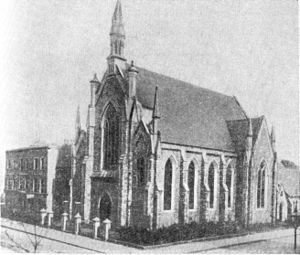
In 1907, an important meeting of the Russian Social Democratic Labour Party took place in Hackney. It was held at the Brotherhood Church on Southgate Road. This meeting was banned in other countries.
Famous people like Lenin, Stalin, and Leon Trotsky attended. They discussed plans for a communist revolution in Russia.
World War One
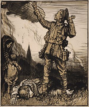
During World War One, the first bomb of the first air raid on London fell in Hackney. It hit 16 Alkham Road, West Hackney, in May 1915. This was from a German airship called LZ 38. No one at that address was badly hurt. But the raid killed seven people elsewhere, including four children. This made the public very angry.
Hackney also raised two infantry battalions for the war. These were the 1/10th (City of London) Battalion (Hackney) and the 2/10th (City of London) Battalion (Hackney). Their cap badge showed St Augustine's Tower. Their motto was Justitia Turris Nostra, which means Justice is our tower.
World War Two Blitz
During the Second World War, Hackney was heavily bombed. 749 civilians died, and many more were hurt or lost their homes. Many Hackney residents also died fighting in the war. Over 600 high explosive bombs, 16 parachute mines, 37 V-1 'doodlebugs', and 10 V-2 rockets hit Hackney. Thousands of incendiary devices also fell.
Important buildings destroyed by bombing included Tudor-era Brooke House and West Hackney church.
After the Wars and the Olympics
After the war, Hackney was rebuilt. It became a very diverse area with many different cultures. In the 1930s, 1940s, and 1960s, far-right groups held rallies here. These were strongly opposed by local people and groups like the 43 Group. This led to clashes, especially in the Ridley Road area of Dalston.
Hackney was one of the host areas for the 2012 Olympic and Paralympic Games. Three venues were in its part of the Queen Elizabeth Olympic Park:
- The Copper Box Arena hosted handball and other sports. This venue is still used today.
- The Riverbank Arena was a temporary venue for field hockey.
- The London Olympics Media Centre is now called Here East.
Affordable Homes
Hackney has worked to provide more affordable housing. They have built many affordable homes. They also used a system where market-rate homes helped pay for the affordable ones. About half of the new homes built in Hackney are affordable. Construction was done in stages to avoid moving current residents out.
Hackney's Geography
Hackney's traditional shape looks like a right-angled triangle. The River Lea valley forms one side. The western boundary follows the Roman A10 road.
The southern boundary partly follows the Regents Canal and Hertford Union Canal. Victoria Park also forms part of this southern edge.
The highest points are around Stamford Hill and Clapton Common. The lowest areas are along the River Lea. The Hackney Brook was the largest natural waterway. It flowed through Hackney but was put into underground pipes in the 1800s.
Hackney includes areas like Homerton, Dalston, De Beauvoir Town, Upper and Lower Clapton, Stamford Hill, Hackney Central, Hackney Wick, South Hackney and West Hackney.
The ground in Hackney varies. Areas near the Lea and Hackney Marshes have alluvium soils. Higher ground has London Clay. Other parts have gravel and flood plain gravel. Hackney is about 15 meters (49 feet) above sea level.
Green Spaces
Hackney has many lovely open spaces where you can relax and play:
- Clapton Common
- Hackney Downs
- Hackney Marshes
- Mabley Green
- London Fields
- Queen Elizabeth Olympic Park (part of it)
- Springfield Park and Spring Hill Recreation Ground
- Stoke Newington Common
- Victoria Park (just outside Hackney, but part of its southern edge)
- Well Street Common
- West Hackney Recreation Ground
- Millfields Park
Getting Around Hackney
Train Stations
Hackney has six train stations. These include Hackney Central railway station and Hackney Downs, both on the London Overground. Hackney Central first opened in 1850. It closed in 1944 but reopened in 1985.
A special walkway connecting Hackney Downs and Hackney Central stations opened in 2015. Before this, passengers had to walk along the street to switch trains.
Hackney Wick opened in 1980. London Fields railway station opened in 1872. It closed due to a fire in 1981 but reopened in 1986.
There have been ideas to extend the Docklands Light Railway (DLR) to Hackney Central. This would connect Hackney to places like Poplar and Canary Wharf.
Bus Routes
Hackney is well-served by many London Buses routes. These include routes 26, 30, 38, 55, 56, 106, 149, 236, 242, 253, 254, 276, 277, 388, 394, 339, 425, and 488. There are also night bus routes like N26, N38, N55, N253, and N277, which run late into the night.
International Connections
Hackney has special connections with several towns and cities around the world. These are called twin towns or sister cities:
 Alexandra, South Africa
 Bridgetown, Barbados
 Göttingen, Germany
 Haifa, Israel
 Presnensky District, Moscow, Russia
 Suresnes, France
Notable People
 | Isaac Myers |
 | D. Hamilton Jackson |
 | A. Philip Randolph |


