
Stepney facts for kids
Quick facts for kids Stepney |
|
|---|---|
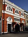
  .jpg) .jpg)  .jpg) Clockwise from top left: St. Dunstan's Church; Stepney Green tube station; Genesis cinema; route 135 at Arbour Square; Stepney Green; the Half Moon pub. |
|

Stepney
|
|
| Population | 16,238 (2011 census. St Dunstan's and Stepney Green Ward) |
| OS grid reference | TQ355814 |
| • Charing Cross | 3.6 mi (5.8 km) WSW |
| London borough | |
| Ceremonial county | Greater London |
| Region | |
| Country | England |
| Sovereign state | United Kingdom |
| Post town | LONDON |
| Postcode district | E1, E14 |
| Dialling code | 020 |
| Police | Metropolitan |
| Fire | London |
| Ambulance | London |
| EU Parliament | London |
| UK Parliament | |
| London Assembly | |
Stepney is a historic area in East London, England. It is part of the London Borough of Tower Hamlets. Stepney is known as a small area today. However, for a long time, it was a much bigger area. This included a large manor and a church parish. Stepney Green is a green space that used to be part of a larger common area.
In the 1800s, Stepney grew very quickly. Many new homes were built for people moving to London. These included workers from other countries and poor Londoners. The area became known for its crowded streets and poverty. It also saw a lot of political activity. During the Blitz in World War II, many homes were destroyed. Later, in the 1960s, old houses were replaced. New tower blocks and modern housing estates were built. Still, you can find some older Georgian architecture and Victorian era homes. These are in places like Arbour Square and around Stepney Green.
Contents
History
What's in a Name?
The name "Stepney" first appeared around the year 1000 AD. It was called Stybbanhyð. This means "Stybba's landing-place." A "hithe" was a place where boats could land. People think this landing spot was at Ratcliff. This is about half a mile south of St Dunstan's Church.
How Stepney's Size Changed
Historically, Stepney was a very large area. It was a manor and an Ancient Parish. This covered most of what we now call the East End. From 1900 to 1965, it was a local government area called the Metropolitan Borough of Stepney. In 1965, this became part of the new London Borough of Tower Hamlets. Today, Stepney does not have official borders. It usually refers to a smaller part of its historic area.
The Ancient Manor and Parish
For hundreds of years, Stepney was a huge manor and parish. It stretched from the City of London to the River Lea. It also went from Stamford Hill down to the Thames. This area is similar to the modern London Borough of Tower Hamlets. It also included the area of Hackney.
The manor's beginnings are not fully known. But its large size and good soil suggest it was given to the Bishop of London. This was to help create the new diocese of London. This happened when St Paul's Cathedral was founded in 604 AD.
St Dunstan's Church was built or rebuilt around 952 AD. It was by Dunstan himself. As the first church, it served the whole manor. So, the early parish of Stepney covered the same large area.
The Domesday Book of 1086 called the area Stibanhede. It said the Bishop of London owned the land. It was 32 hides large. This land was used for farming, meadows, and woods. It also had four mills. The survey counted 183 households. This means about a thousand people lived in the manor.
The Bishop of London had a manor house in Stepney. It was first mentioned in 1207. This house was later called Bishops Hall or Bonner Hall. It was in Bethnal Green. Later, Edward VI gave Stepney to the Wentworth family.
The Mother Church of the East End
St Dunstan's Church was founded around 952 AD. It was by St Dunstan when he was Bishop of London. The church was named after him when he became a saint in 1029. This made him the patron saint of Stepney. The church's bells are even mentioned in the nursery rhyme, Oranges and Lemons:
" 'When will that be'? say the bells of Stepney"
The church is known as "The Mother Church of the East End." This is because its huge parish covered most of inner East London. As the population grew, many new churches were built. These were "daughter parishes" of St Dunstan's. It is also called "The Church of the High Seas." This is because of its strong links to sailors and the sea.
Stepney was a very large Ancient Parish. It was part of the Tower division of Middlesex. The parish included areas like Mile End Old Town, Ratcliff, Bethnal Green, and Poplar. These smaller areas were called Hamlets. They later became independent parishes.
Special Rules and Customs
The Constable of the Tower of London had important duties in Stepney. They were in charge of the Thames below the Tower. They also looked after parts of the Lea. In return, people from Stepney helped protect the Tower. These arrangements led to the creation of the Tower Division.
Stepney also had an unusual way of passing down land. It used a custom called gavelkind. This meant land was divided equally among all sons. This was different from most of England.
St Dunstan's Church had a long connection with the sea. Until the 1800s, it registered births, marriages, and deaths for British sailors. This included those born at sea. This maritime link is remembered in an old rhyme:
"He who sails on the wide sea, is a parishioner of Stepney"
How the Parish Divided
The population grew very fast. So, the large parish of Stepney began to divide. Hackney became independent in the 1100s. Whitechapel followed in the 1300s, and Bromley in the 1500s. Other areas like Bethnal Green and Poplar also formed new parishes. These divisions often needed a special law from Parliament.
By 1819, the main part of Stepney was smaller. It had three hamlets: Mile End New Town, Ratcliffe, and Mile End Old Town. This area was about 830 acres.

Until 1837, church and civil boundaries were the same. But after that, the Church of England divided its parishes more. This was to help local people, especially in crowded areas like Stepney. So, the civil and church boundaries became different. By 1890, the old parish was split into 67 church parishes.
In 1866, the civil parish of Stepney officially ended. Its three hamlets became independent civil parishes.
Stepney's Growth as a Town
Like much of the East End of London, Stepney was not very populated until the 1800s. It had scattered farms and small villages. The area grew into a town because of trade along the river. Also, new roads and railways helped. People who lost their homes in other parts of London moved here. Many immigrants also came looking for work. They found cheap housing being built in Stepney.
The Trinity Green Almshouses were built in 1695. They provided homes for sailors who had retired. They are the oldest almshouses in Central London.
Malplaquet House is named after a famous battle in France in 1709. It was home to small businesses. These included a bookmaker and a printer.
The Leonard Montefiore memorial fountain is on Stepney Green. It is named after a young writer and helper. Leonard Montefiore was known for his charity work in the East End. He died in 1879 at age 27. The fountain has a poem carved on its side:
"Clear brain and sympathetic heart,
A spirit on flame with love for man,
Hands quick to labour, slow to part,
If any good since time began,
A soul can fashion such souls can."
_from_the_east_half_of_the-_%27Plan_of_the_cities_of_London_and_Westminster,_the_borough_of_Southwark_and_parts_adjoining_shewing_every_house%27_RMG_K0929.jpg)

In 1883, a group of actors arrived in London. They were refugees. They started the Russian Jewish Operatic Company. They performed near Stepney Green tube station. Soon, they opened their own theatre in Brick Lane.
Stepney Green railway station opened in 1902. It was part of a new railway line. The station became part of the London Underground in 1950.
In the early 1900s, Stepney had a large Jewish community. It was one of the biggest in England.
On July 31, 1987, the Docklands Light Railway started running. New platforms were built at Stepney East. This station was renamed Limehouse earlier that year.
Governance

The Lord-Lieutenant Ken Olisa is the King's representative for Greater London. This includes Stepney. This is an honorary role. It has no political power.
Stepney is part of the Bethnal Green and Stepney area. This area elects a Member of Parliament (MP). Since 2010, Rushanara Ali of the Labour Party has been the MP.
London has a directly elected Mayor of London. The current mayor is Sadiq Khan. Stepney is also part of the City and East area. This area elects a member to the London Assembly. Unmesh Desai of the Labour Party holds this seat.
The local government for Stepney is the Tower Hamlets London Borough Council. It also has a directly elected mayor, John Biggs. Stepney has local councillors from three wards: St Dunstan's, Bethnal Green, and Stepney Green.
Geography

The Stepney Green Conservation Area was created in 1973. It covers the area once known as Mile End Old Town. This area is very important for its history and buildings. It includes buildings around Mile End Road and Stepney Green. It is just north of the old village of Stepney.
Stepney Green became a street of homes in the 1400s. Now, it refers to the area in north Stepney. A brewery started here in 1738. It became Charrington and Co. in 1897. The brewery building is now a retail park. But the old office building still stands.
Nearby Places
Community
The Stepney Community Trust is a local charity. It started in 1982 to help with housing and social problems. It works to improve the area for local people.
Stepney City Farm is a city farm. It offers tours, workshops, and other activities. It was founded in 1979. Local people helped turn an old wasteland into the farm. This land was left after a World War II bomb destroyed a church.
The Stepney Historical Trust was set up in 1989. Its goal is to teach people about Stepney's history. It has put up plaques on important historical sites.
Jewish Care was formed in 1990. It helps meet the needs of the Jewish community. It is based at the Brenner Centre.
The City Gateway Women Programmes help women in Stepney. They offer chances to become independent and gain confidence. They also help women find jobs and learn new skills.
Demographics
The East End of London has always welcomed immigrants. Stepney has been home to many different groups. In the 1600s, French Huguenots arrived. In the 1700s, Irish people came. Later, Ashkenazi Jews came from Eastern Europe. From the 1960s, the Bangladeshi community settled here.
Today, Stepney is still very diverse. It has young Asian families and older East Enders. There are also students and a growing middle class. The 2011 UK Census showed that 47% of the population was Bengali. This is the highest percentage in Southern England. White British people make up just over a quarter of the St. Dunstan's and Stepney Green ward.
Education
Stepney All Saints School is a Church of England school. It opened in 1710 as the Sir John Cass School. It merged with another school in 1966. It got its current name in 2020.
Stepney Green Maths, Computing and Science College is a school for boys. It offers many subjects and extra activities. These activities happen before, during, and after school.
Sports
Stepney F.C. is a local association football team. They play in the Inner London Football League.
The street Senrab Street gave its name to Senrab F.C.. This is a youth football team. Many famous professional players started their careers at Senrab F.C.
Transport

Stepney is connected to the London Underground. You can use Stepney Green tube station. It is on the Hammersmith & City and District lines.
Many London Buses services cover the area. Routes like the 25, 205, and 115 run through Stepney.
Air quality is monitored in the area. In 2017, a site in nearby Mile End recorded an average of 48 μg/m3. Another site on Mile End Road recorded 52 μg/m3.
Notable people
Many famous people were born or lived in Stepney.
The English doctor Richard Mead was born here. He helped us understand how diseases spread.
Other famous people born in Stepney include:
- Entertainer Des O'Connor
- Actors Steven Berkoff, Terence Stamp, Anita Dobson, and Nicola Walker
- Playwright Arnold Wesker
- Gardener Rachel De Thame
- Television executive Alan Yentob
- Artist Frank Paton
- Drummers Kenney Jones and Jah Wobble
- Singers Kenny Lynch and his sister Maxine Daniels
- Singer Charles Coborn
- Footballers Ledley King, Ashley Cole, and Mark Lazarus
- Boxer "Bombardier" Billy Wells
- Businessman Roy Shaw
- Boxer Sammy McCarthy
- Sportswriter Norman Giller
- Politician Wes Streeting
Musicians Monty Norman (who wrote the James Bond Theme) and Lionel Bart (who created Oliver!) were also born in Stepney. So was musician Wiley, who is known as the founder of grime music.
Alf Salisbury, a British activist, was born in Stepney. He fought in the Battle of Cable Street. He also fought in the Spanish Civil War. Later, he worked to change how news outlets talked about people with Down Syndrome.
In popular culture
Stepney is mentioned in several songs and films:
- The 1965 Rolling Stones song Play with Fire mentions Stepney.
- Elton John's song "Bitter Fingers" also refers to Stepney.
- Folk duo Ruby Throat released a song called "Forget Me Nots of Stepney."
- In the film Lock, Stock and Two Smoking Barrels, a line says, "Hand made in Italy, hand stolen in Stepney."
Images for kids
-
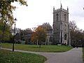
St. Dunstan's Church
-
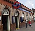
Stepney Green tube station
-
The Half Moon pub
-

Genesis cinema
-
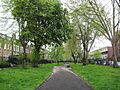
Stepney Green
-

Route 135 at Arbour Square
See also
 In Spanish: Stepney para niños
