Mile End facts for kids
Quick facts for kids Mile End |
|
|---|---|
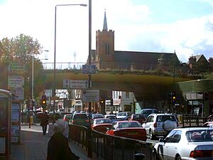
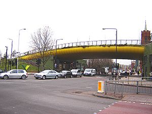 The Green Bridge carries Mile End Park over the A11 Mile End Road |
|
| OS grid reference | TQ365825 |
| • Charing Cross | 4.2 mi (6.8 km) WSW |
| London borough | |
| Ceremonial county | Greater London |
| Region | |
| Country | England |
| Sovereign state | United Kingdom |
| Post town | LONDON |
| Postcode district | E1, E3 and E14 |
| Dialling code | 020 |
| Police | Metropolitan |
| Fire | London |
| Ambulance | London |
| EU Parliament | London |
| UK Parliament |
|
| London Assembly | |
Mile End is a cool area in London, England. It is located in the London Borough of Tower Hamlets. This area is in East London and is part of the famous East End. It is about 4.2 miles (6.8 km) east of Charing Cross, a central spot in London.
Mile End is situated on the road from London to Colchester, which is called Mile End Road here. It was one of London's earliest suburbs. It was also known as Mile End Old Town. This name helped tell it apart from another, separate place called Mile End New Town. In 2011, about 28,544 people lived in Mile End.
History
What's in a Name? The Story of Mile End
The name Mile End was first written down in 1288 as La Mile ende. It comes from old English words meaning 'the hamlet a mile away'. This distance was measured from Aldgate, one of the gates in the old London's defensive wall. The London-to-Colchester road led right to it. Around 1691, the area became known as Mile End Old Town. This happened because a new, separate settlement nearby was called Mile End New Town.
How Mile End Began
Even though there are old records of people living here, digs show that Mile End was mostly countryside before the 1300s. Not many buildings stood here back then.
The road from Aldgate to Colchester is known as Mile End Road in this area. In the Middle Ages, it was called Aldgatestrete because it started at Aldgate. Later, it became known as the Great Essex Road.
The River Lea, which was the old border of Essex, used to be much wilder. It was a big challenge to cross. The road, which has been around since Roman times, used to cross the river at Old Ford. This was in northern Bow. But after Bow Bridge was built in 1110, the road moved to its current path. The new bridge was about 900 meters (0.56 miles) south-east of the old ford. This meant a new road path had to be made.
The open land next to Mile End Road was called Mile End Green. It was a large common area. People from London often gathered here. You can still see this in the name of Assembly Passage, a short road about 470 meters (0.29 miles) west of Stepney Green tube station.
The Peasants' Revolt in Mile End
In 1381, a big uprising started against tax collectors. It began in Brentwood and quickly spread. Soon, it reached villages all over South-East England. The rebels from Essex were led by a priest named Jack Straw. The men from Kent were led by Wat Tyler. Both groups marched towards London.
On June 12, the Essex rebels, a huge group of 100,000 men, set up camp at Mile End. The next day, the Kent rebels arrived at Blackheath. On June 14, the young King Richard II, who was still a teenager, rode to Mile End. He met the rebels there and signed their demands. However, the king later had the leaders and many rebels put to death.
Mile End Grows and Changes
By the late 1500s, new buildings were being built in Mile End. This continued through the 1700s. The area grew as a place for working-class and lower-class homes. Often, new people moving to London, including immigrants, lived here.
In 1811, the Bancroft Road Cemetery opened for burials. It was used by a Jewish group called the "Maiden Lane synagogue". By 1884, the cemetery was in bad shape. It was full by 1895.
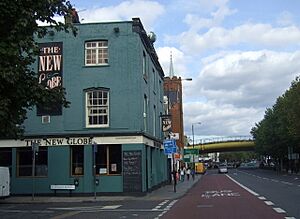
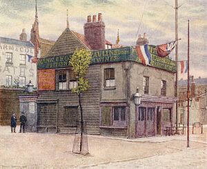
In 1820, the New Globe pub opened next to the "Globe Bridge". Its license might have moved from another pub called the Cherry Tree, which closed around that time.
Mile End Hospital started as a hospital for the local workhouse in 1859. In 1883, the building was rebuilt and called the "Mile End Old Town Infirmary". A school to train nurses was added in 1892. During the First World War, it became a military hospital. In 1930, it was renamed "Mile End Hospital". It joined the National Health Service in 1948.
In 1882, a writer named Sir Walter Besant suggested building a Palace of Delight. This would have concert halls, reading rooms, art galleries, and classes. It would also host parties and dances. A businessman named Edmund Hay Currie helped make this happen. They bought five acres of land on Mile End Road. The Queen's Hall was opened by Queen Victoria on May 14, 1887. This complex had a library, swimming pool, gym, and winter garden by 1892. It offered both fun entertainment and education. In 1892, 8,000 tickets were sold for classes! By 1900, you could even get a science degree from the University of London here.
The building was destroyed by fire in 1931. But the Draper's Company helped rebuild it. They created Queen Mary College in December 1934. A new "People's Palace" was built in 1937 but closed in 1954.
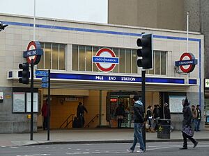
In 1902, Mile End tube station opened. Electric train services started in 1905. The District Railway (now the District line) provided the first services. Then the Metropolitan line followed in 1936 (this part is now the Hammersmith & City line). In 1946, the station was made bigger and rebuilt. Services for the Central line started on December 4, 1946.
In 1903, The Guardian Angels Church opened. A wealthy man paid for it as a memorial to his sister, who did charity work in the East End.
In 1933, a boxing ring called Mile End Arena opened behind Mile End station. It was only used in summer and closed in 1953.
Mile End During World War II
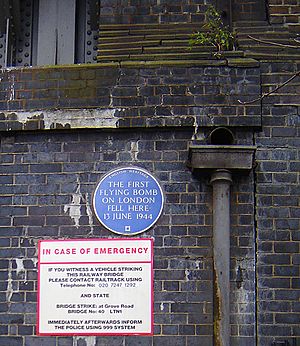
Mile End suffered a lot during earlier air raids. It was also hit by the very first V-1 flying bomb to strike London. On June 13, 1944, this "doodlebug" hit near the railway bridge on Grove Road. A blue plaque now marks this spot. Eight people died, 30 were hurt, and 200 lost their homes because of the blast.
After the Second World War, parts of Mile End were left empty and damaged for many years. Eventually, the area was cleared to make Mile End Park bigger.
Mile End Today
The Stepney Green Conservation Area was created in 1973. It covers the area once known as Mile End Old Town. This is a large area with special buildings and history. It is important to protect and improve its unique look.
In 1990, the Ragged School Museum opened. It is in the building that used to be the Copperfield Road Ragged School.
On June 17, 1995, the Mile End Stadium hosted a concert by the band Blur. About 27,000 fans came to see them play.
A special project called the Green Bridge opened in 2000. It was funded by the Millennium Commission. This bridge is for people walking and cycling. It goes over the busy A11 (Mile End Road). The bridge connects the two parts of Mile End Park, making one long park. It also has new shops built underneath.
The St Clement's Hospital site closed in 2005. Its services moved to a new mental health facility at Mile End Hospital.
The Palm Tree pub building was given a special historic status in 2015.
The Night Tube service started at Mile End tube station (on the Central line) on August 19, 2016. Since 2016, the northern part of Mile End has been part of the Bow Roman Road Neighbourhood Forum. This includes shops under The Green Bridge and the Mile End Climbing Wall.
A 165-year-old pub called "The Carlton" closed in May 2018. This pub was very important to the local community. It was one of the few buildings in the area to survive the World War II bombings. The building was later completely torn down without proper permission.
Governance
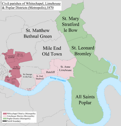
Mile End used to be a small area within the large old parish of Stepney. This was part of Middlesex county. However, many local government jobs were handled by the Tower Division. This group was led by the Lord-Lieutenant of the Tower Hamlets.
The Tower Division stopped its work when Mile End became part of the new County of London in 1889. The County of London was then replaced by Greater London in 1965.
For more local matters, Mile End joined the Stepney poor law union in 1836. It became a single civil parish for poor law purposes in 1857.
Mile End was part of the Metropolitan Police District from 1830.
When the Metropolitan Board of Works was created in 1855, the local council of Mile End Old Town gained the power to elect its own members. Their meeting hall was on Bancroft Road.
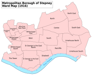
The parish became part of the County of London in 1889. In 1900, it became part of the Metropolitan Borough of Stepney.
In 1965, Stepney became part of the London Borough of Tower Hamlets.
There was a Mile End Parliament constituency from 1885 to 1950. It was famous for electing a Communist Party MP, Phil Piratin, between 1945 and 1950. Today, the area is covered by the Bethnal Green and Bow and Poplar and Limehouse constituencies.
Geography
Mile End is in London's East End. It has a unique landmark called the "Green Bridge". People sometimes call it the "banana bridge" because of its yellow underside. This bridge was designed by CZWG Architects and opened in 2000. It carries Mile End Park over the busy Mile End Road. The top of the bridge has gardens and water features. There are also shops and restaurants built underneath.
Ackroyd Drive Greenlink, Tower Hamlets Cemetery Park, and Mile End Park together form a large green area. The Greenlink is a long, narrow park. Roads divide it into five parts: Cowslip Meadow, allotments, Blackberry Meadow, Peartree Meadow, and Primrose Meadow.
Sport and Leisure
Mile End has a local football club called Sporting Bengal United F.C.. They play at Mile End Stadium. The Mile End Skate Park offers a safe place for skateboarding and other skate sports. There are many green spaces in Mile End. One of them is the Tower Hamlets Cemetery Park. It is one of London's "Magnificent Seven" historic cemeteries.
Media
The band Pulp sang about Mile End in their 1995 song "Mile End". This song was on the Trainspotting movie soundtrack. The song describes people living in an abandoned apartment in a run-down building.
In 2009, the music video for "Confusion Girl" by Frankmusik was filmed in Mile End Park.
In 2011, the music video for "Heart Skips a Beat" by Olly Murs and Rizzle Kicks was filmed in Mile End's skate park.
Transport
 |
Bethnal Green | Bow (Victoria Park) |
Bow |  |
| Stepney | Bow | |||
| Stepney | Limehouse | Limehouse |
Tube and Train Services
Mile End tube station is on the London Underground Central, District, and Hammersmith & City lines. These lines connect Mile End directly to the East End, the City of London, and Central London. The Central line also links the area to Stratford and Essex in the east, and London's West End. The station is in London fare zone 2.
Bus Services
You can find bus stops on Mile End Road, Burdett Road, and Grove Road.
London Bus routes 25, 205, 277, 309, 323, 339, 425, D6, D7, and night buses N25, N205 and N277 stop in the area.
Buses connect Mile End directly to many places across London. These include Canary Wharf, the City of London, King's Cross, Paddington, and Stratford.
Roads
The A11 (Mile End Road) runs through Mile End from east to west. It connects the area to Aldgate in the west and Stratford in the east. At Stratford, the A11 meets the A12. From there, you can continue towards Ilford, the M11 (for Stansted Airport), and other places in Essex.
The A1205 (Grove Road/Burdett Road) takes traffic north towards Victoria Park and Hackney. This road ends in the south near Limehouse and Canary Wharf.
Air Quality
The London Borough of Tower Hamlets checks the air quality along the roads in Mile End. In 2017, the average levels of Nitrogen Dioxide (NO2) in the area were higher than the UK's air quality goal. The goal is 40 micrograms per cubic meter (40μg/m3).
A monitoring site in Mile End recorded an average of 48μg/m3 in 2017. Other sites on Mile End Road also showed higher levels than the goal. For example, a site near Globe Road in Stepney recorded 52μg/m3. Another site near Harford Street recorded 41μg/m3.
Breathing in too much NO2 can be bad for your health. It has been linked to lung diseases and breathing problems.
Cycling Routes
Mile End is part of London's, national, and international cycling networks. Transport for London (TfL) and the London Borough of Tower Hamlets provide public cycling infrastructure here. Some routes include:
- National Cycle Route 1 (NCR 1) – This is a long cycling route for fun. It goes between Dover, Kent, and the Shetland Islands in Scotland. It is part of the National Cycle Network. The route goes through Mile End Park on paths where there are no cars.
- Cycle Superhighway 2 (CS2) – This is a cycling route for people who cycle to work. It goes from Aldgate in the City to Stratford in the east. Most of this route has separate cycle tracks that are blue. It was improved in April 2016, with separate tracks replacing older cycle lanes.
- Cycleway between Hackney and the Isle of Dogs – This is a proposed cycling route from 2019. The plan is for the southern part of this route to have a continuous, car-free cycle track between Mile End and Canary Wharf.
- EuroVelo 2 ("The Capitals Route") – This is an international cycling route for fun. It goes between Moscow, Russia, and Galway, Ireland. In Mile End, it follows the same path as NCR 1.
- Regent's Canal towpath – This is a path for both walkers and cyclists. It goes from Limehouse to Angel. The path is continuous and has no cars. You can get to it in Mile End through Mile End Park. This route connects Mile End directly to Hackney and Dalston.
Notable People
- Mabel Lucie Attwell (1879–1964), a British artist who drew pictures for children's books, was born in Mile End.
- Rokhsana Fiaz, who became the Labour Mayor of Newham in 2018, was born in Mile End Hospital.
- Craig Fairbrass, an actor known for EastEnders, is from here.
- Muzzy Izzet, a professional footballer, was part of the Turkey team that reached the semi-finals of the 2002 FIFA World Cup.
- Charles Pope (1883–1917), who received the Victoria Cross medal in June 1917, was born in Mile End.
- Pop singer Samantha Fox was born here.
- Jason Tindall, a former professional footballer and current assistant manager at Newcastle United, is from Mile End.
See also
 In Spanish: Mile End para niños
 | John T. Biggers |
 | Thomas Blackshear |
 | Mark Bradford |
 | Beverly Buchanan |


