Harold Hill facts for kids
Quick facts for kids Harold Hill |
|
|---|---|
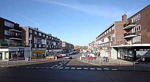
 View from St George's Church, Chippenham Road, Harold Hill |
|
| OS grid reference | TQ545925 |
| • Charing Cross | 16.6 mi (26.7 km) WSW |
| London borough | |
| Ceremonial county | Greater London |
| Region | |
| Country | England |
| Sovereign state | United Kingdom |
| Post town | ROMFORD |
| Postcode district | RM3 |
| Dialling code | 01708 |
| Police | Metropolitan |
| Fire | London |
| Ambulance | London |
| EU Parliament | London |
| UK Parliament |
|
| London Assembly |
|
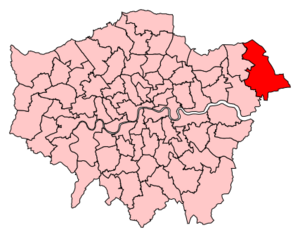
Harold Hill is a suburban area in East London. It is part of the London Borough of Havering. This area is about 27 kilometers (16.6 miles) northeast of Charing Cross. It is an important local center in the London Plan.
The name Harold Hill comes from King Harold II. He owned the land of manor of Havering-atte-Bower. King Harold was killed in the Battle of Hastings in 1066. Harold Hill is on the eastern edge of London's built-up area.
The London County Council built many homes in Harold Hill. This project started after the Greater London Plan of 1944. It helped solve the housing shortage in central London. Before these homes were built, the area was home to Dagnam Park house and its grounds. It was part of Essex county. In 1965, Harold Hill became part of Greater London. The first person to buy their council house from the Greater London Council did so here in 1967. The local council, Havering London Borough Council, is now working on improving the area.
Contents
History of Harold Hill
How Harold Hill Was Built
Harold Hill was a planned community. It was designed as a new town on the edge of London. This plan was part of the Greater London Plan in 1944.
The London County Council bought 850 acres of land in 1947. This land was the remaining part of Dagnams. Before this, the land was mostly parkland, woods, and farms. Harold Hill was in an area called the Metropolitan Green Belt. But an exception was made for building homes. This was because London needed many new houses after the Second World War.
Because homes were needed quickly, some houses were built in sections and put together. Building 7,631 permanent homes started in 1948. These homes were for about 25,000 people. The project was finished by 1958. Harold Hill has many parks and green spaces. Most homes are made of brick. They are mainly rows of houses and some flats. The plan also included places for the community. Three shopping areas were built. Some factories already existed near the A12 road. These were kept.
Local Government
Harold Hill is divided into two voting areas. These are the Heaton and Gooshays wards. Heaton covers the western part, and Gooshays covers the eastern part. Each ward chooses three councillors to serve on the Havering London Borough Council.
Harold Hill is also part of a larger area for national elections. It is in the Hornchurch and Upminster area for the UK Parliament. For the London Assembly, it is in the Havering and Redbridge area.
Geography and Nature
Harold Hill is on the northeastern edge of London. It is about 27 kilometers (17 miles) from Charing Cross. The area has clear natural borders. The A12 road is to the south. The M25 motorway is to the east. To the north, the built-up area ends at Noak Hill Road.
Harold Hill has many parks and woods. These include Central Park and Dagnam Park. The land is gently hilly. A small stream called Carter's Brook and Paine's Brook flows through the middle. It is a branch of the River Ingrebourne.
Nearby areas include Gidea Park to the south and Noak Hill to the north. Collier Row is to the west, and Great Warley is to the east. Harold Hill is part of the Romford post town. It is in the RM3 postcode district. This district also includes Harold Wood and Noak Hill. Weather information for Harold Hill comes from the Greenwich weather station.
| Climate data for London (Greenwich) | |||||||||||||
|---|---|---|---|---|---|---|---|---|---|---|---|---|---|
| Month | Jan | Feb | Mar | Apr | May | Jun | Jul | Aug | Sep | Oct | Nov | Dec | Year |
| Record high °C (°F) | 14.0 (57.2) |
19.7 (67.5) |
21.0 (69.8) |
26.9 (80.4) |
31.0 (87.8) |
35.0 (95.0) |
35.5 (95.9) |
37.5 (99.5) |
30.0 (86.0) |
28.8 (83.8) |
19.9 (67.8) |
15.0 (59.0) |
37.5 (99.5) |
| Mean daily maximum °C (°F) | 8.3 (46.9) |
8.5 (47.3) |
11.4 (52.5) |
14.2 (57.6) |
17.7 (63.9) |
20.7 (69.3) |
23.2 (73.8) |
22.9 (73.2) |
20.1 (68.2) |
15.6 (60.1) |
11.4 (52.5) |
8.6 (47.5) |
15.2 (59.4) |
| Mean daily minimum °C (°F) | 2.6 (36.7) |
2.4 (36.3) |
4.1 (39.4) |
5.4 (41.7) |
8.4 (47.1) |
11.5 (52.7) |
13.9 (57.0) |
13.7 (56.7) |
11.2 (52.2) |
8.3 (46.9) |
5.1 (41.2) |
2.8 (37.0) |
7.5 (45.5) |
| Record low °C (°F) | −10.0 (14.0) |
−9.0 (15.8) |
−8.0 (17.6) |
−2.0 (28.4) |
−1.0 (30.2) |
5.0 (41.0) |
7.0 (44.6) |
6.0 (42.8) |
3.0 (37.4) |
−4.0 (24.8) |
−5.0 (23.0) |
−7.0 (19.4) |
−10.0 (14.0) |
| Average precipitation mm (inches) | 51.6 (2.03) |
38.2 (1.50) |
40.5 (1.59) |
45.0 (1.77) |
46.5 (1.83) |
47.3 (1.86) |
41.1 (1.62) |
51.6 (2.03) |
50.4 (1.98) |
68.8 (2.71) |
58.0 (2.28) |
53.0 (2.09) |
591.8 (23.30) |
| Average rainy days (≥ 1.0 mm) | 10.8 | 8.5 | 9.6 | 9.4 | 9.0 | 8.3 | 8.0 | 7.6 | 8.5 | 10.7 | 10.1 | 9.9 | 110.4 |
| Average snowy days | 4 | 4 | 3 | 1 | 0 | 0 | 0 | 0 | 0 | 0 | 1 | 3 | 16 |
| Average relative humidity (%) | 81.0 | 76.0 | 69.0 | 64.0 | 62.0 | 60.0 | 60.0 | 62.0 | 67.0 | 73.0 | 78.0 | 82.0 | 69.5 |
| Mean monthly sunshine hours | 49.9 | 71.4 | 107.1 | 159.8 | 181.2 | 181.0 | 192.1 | 195.1 | 138.9 | 108.1 | 58.5 | 37.4 | 1,480.5 |
| Source 1: Record highs and lows from BBC Weather, except August and February maximum from Met Office | |||||||||||||
| Source 2: All other data from Met Office, except for humidity and snow data which are from NOAA | |||||||||||||
| Climate data for London (Heathrow airport 1981−2010) | |||||||||||||
|---|---|---|---|---|---|---|---|---|---|---|---|---|---|
| Month | Jan | Feb | Mar | Apr | May | Jun | Jul | Aug | Sep | Oct | Nov | Dec | Year |
| Mean daily maximum °C (°F) | 8.1 (46.6) |
8.4 (47.1) |
11.3 (52.3) |
14.2 (57.6) |
17.9 (64.2) |
21.0 (69.8) |
23.5 (74.3) |
23.2 (73.8) |
19.9 (67.8) |
15.5 (59.9) |
11.1 (52.0) |
8.3 (46.9) |
15.2 (59.4) |
| Mean daily minimum °C (°F) | 2.3 (36.1) |
2.1 (35.8) |
3.9 (39.0) |
5.5 (41.9) |
8.7 (47.7) |
11.7 (53.1) |
13.9 (57.0) |
13.7 (56.7) |
11.4 (52.5) |
8.4 (47.1) |
4.9 (40.8) |
2.7 (36.9) |
7.4 (45.4) |
| Average precipitation mm (inches) | 55.2 (2.17) |
40.9 (1.61) |
41.6 (1.64) |
43.7 (1.72) |
49.4 (1.94) |
45.1 (1.78) |
44.5 (1.75) |
49.5 (1.95) |
49.1 (1.93) |
68.5 (2.70) |
59.0 (2.32) |
55.2 (2.17) |
601.7 (23.68) |
| Average rainy days (≥ 1.0 mm) | 11.1 | 8.5 | 9.3 | 9.1 | 8.8 | 8.2 | 7.7 | 7.5 | 8.1 | 10.8 | 10.3 | 10.2 | 109.6 |
| Mean monthly sunshine hours | 61.5 | 77.9 | 114.6 | 168.7 | 198.5 | 204.3 | 212.0 | 204.7 | 149.3 | 116.5 | 72.6 | 52.0 | 1,632.6 |
| Source: Met Office | |||||||||||||
Getting Around Harold Hill
The closest train station is Harold Wood. It is about 1.6 kilometers (1 mile) south of the center of Harold Hill. This station is on the Elizabeth line. The nearest London Underground station is Upminster. It is about 4.8 kilometers (3 miles) to the south.
Transport for London runs several bus routes in Harold Hill. These include routes 174, 256, 294, 346, 496, 499, and N86.
Schools and Learning
School History
By the early 1960s, Harold Hill had six secondary schools:
- Broxhill Secondary Modern (for boys and girls), near Broxhill Road and Noak Hill Road.
- Harold Hill Grammar School (for boys and girls), in Appleby Drive.
- Harrowfield Secondary Modern School (for boys), in Settle Road.
- Harrowfield Secondary Modern School (for girls), also in Settle Road, but run separately.
- Quarles Secondary Modern School (for boys), in Tring Gardens.
- Quarles Secondary Modern School (for girls), also in Tring Gardens, but run separately.
These schools were built for the many children born after the Second World War. Later, some schools merged. Broxhill and Harold Hill Grammar became Bedfords Park Comprehensive. Quarles Boys' and Girls' Schools joined with Harrowfield to form the Neave School. This school later became King's Wood.
Schools Today
After more changes, Harold Hill now has one main secondary school. It is called Drapers' Academy. It is located on the site of the old Harrowfield/Neave/King's Wood schools.
Havering College is a college for further education. It is for both boys and girls. It is located where the former Quarles Secondary Modern Schools used to be, in Tring Gardens.
Community Life
Every year, Harold Hill hosts a community festival. It is called the Harold Hill Festival. It usually takes place in Central Park in early July.
The musician Ian Dury mentioned Harold Hill in his song "This Is What We Find." The song talks about a "Home improvement expert Harold Hill from Harold Hill."
Harold Hill has seen many improvements recently. The council built the Myplace centre. This is a new community and performance space. It gives young people a safe place to spend time. Drapers' Academy has also become one of the fastest improving schools in England. This helps Harold Hill's future. The Queen even visited Drapers' Academy in October 2012. This was her first visit to Harold Hill.
Bedrock is a local hospital radio service. You can listen to it online. It shares health information and local entertainment. Radio Harold Hill started in 2013. It is a local community radio station. You can listen to it online and on mobile apps.
Sports in Harold Hill
Harold Hill has its own local football club. It is called Harold Hill F.C.. They play in the Mid-Essex League Premier Division. Their home ground is at the Henderson Sports & Social Club, Kenilworth Avenue.
 | Dorothy Vaughan |
 | Charles Henry Turner |
 | Hildrus Poindexter |
 | Henry Cecil McBay |


