
Royal Liberty of Havering facts for kids
| Havering Havering-atte-Bower |
|
| Geography | |
| Status | Royal manor (11th century–1828) Liberty (1465–1892) |
| 1831 area | 12,550 acres (50.8 km2) |
| 1892 area | 12,550 acres (50.8 km2) |
| HQ | Court House, Market Place, Romford |
| History | |
| Origin | Hornchurch parish in the Becontree Hundred of Essex |
| Created | 12th century |
| Abolished | 1 July 1892 |
| Succeeded by | Reincorporated with Essex |
Quick facts for kids Demography |
|
|---|---|
| 1831 population | 6,812 |
| Politics | |
| Governance | Havering Quarter Sessions |
 |
|
| Subdivisions | |
| Type | Chapelries (later became parishes) |
 |
|
| Units |
|
Havering, also known as Havering-atte-Bower, was a special area in England. It was once a royal manor, which means it was owned by the King or Queen. It was also an ancient liberty, a place with its own special rules and freedoms. Today, this area is part of the London Borough of Havering in Greater London, and the borough is named after it.
From the 11th century until the 19th century, the King or Queen owned Havering. A royal home called Havering Palace was located here from the 1200s to the late 1600s. The area of Havering was the same as the old parish of Hornchurch. This parish was divided into three smaller areas: Havering, Hornchurch, and Romford.
Contents
History of Havering
What Does Havering Mean?
The name Havering first appeared in the 1086 Domesday Book. This was a very old survey of England. The name "Haueringas" means 'the settlement of the family or followers of a man named Hæfer'. This was an old folk name.
Later, in the 1200s, the extra part -atte-Bower was added. This means 'at the royal residence'. So, Havering-atte-Bower means 'Havering at the royal home'. Both the London Borough of Havering and the small village of Havering-atte-Bower still use these names today.
How Havering Started
By the early 1100s, Havering Palace was already a well-known hunting lodge for the royals. This suggests that the King or Queen owned the land of Havering even before 1066. We don't know exactly when it became royal property.
In 1086, the Domesday Book listed Havering as part of the Becontree hundred in Essex. A "hundred" was an old way of dividing land. The King or Queen directly owned Havering. They were the "lord of the manor," which meant they were in charge of the land.
Because the King or Queen didn't usually live in Havering, and they didn't appoint someone to rule for them, the people of Havering had a lot of freedom. They could mostly govern themselves. By 1251, nearly 2,000 people lived in Havering.
Special Freedoms: The Liberty Charters
A "liberty" was a special area that had more freedom from the usual laws of the county. Havering became a liberty in 1465, when King Edward IV issued a special document called a "charter." This charter confirmed many rights that the people of Havering already had.
To celebrate this, a special copper coin was made in the late 1700s. It was unique because it showed the date 1465. The charter gave the people of Havering many benefits:
- They didn't have to pay certain taxes.
- They had their own local judges (called magistrates) and their own jail (called a gaol).
- They were free from certain legal orders from the main Essex courts.
- The famous Romford Market was also guaranteed by this special agreement.
How Havering Was Governed
The liberty of Havering was run by several important officials. These included a high steward, a deputy steward, a clerk of the peace, and a coroner. The high steward was chosen by the King or Queen, who owned the land. The deputy steward was appointed by the high steward. The clerk of the peace and the coroner were chosen by the people living in Havering.
In 1848, there were also other officers like a high bailiff, an under bailiff, and constables (like police officers). A place called Gallows Corner was used for carrying out punishments in the liberty.
The liberty was originally part of the large Hornchurch parish. This parish was divided into eight smaller areas called wards. Over time, some of these wards became more independent. For example, the 'Romford side' (which included Romford Town, Harold Wood, Collier Row, Noak Hill, and Havering) started to govern itself. Later, Havering became a separate parish in the 1780s, and Romford became its own parish in 1849.
The End of the Liberty
In 1828, the King sold the land of Havering. This meant that the right to choose the high steward and the judges of the liberty went to the new private owners.
During the 1800s, new local groups were created to manage things like helping the poor or public health. These new groups slowly took away some of the liberty's powers. Laws like the Local Government Act of 1888 also changed things. This law meant that the liberty's property was joined with the county's property. The jobs of high steward and deputy steward were no longer filled.
However, the liberty still had its own court with three judges. One of these judges was chosen by the people of Havering. The last election for this judge happened on July 3, 1891.
Finally, on May 9, 1892, a special government decision was made. This decision officially joined the Liberty of Havering-atte-Bower with the county of Essex. This change took effect on July 1, 1892. The last high bailiff received a small payment for life, and the coroner became an employee of the county.
In 1894, under a new law, the central part of Romford parish became the Romford Urban District. The rest of the liberty became part of the Romford Rural District.
Today, the London Borough of Havering was created in 1965. It includes the original area of the liberty and other nearby places. You can still see the name "Liberty" in places like the Liberty Shopping Centre and Royal Liberty School.
Geography of Havering
The old liberty of Havering was partly surrounded by rivers. To the south, the River Thames formed a short border with Erith. To the east, the River Ingrebourne was the border with another area of Essex called Chafford hundred. This border was next to parishes like Upminster and Rainham.
To the north, the land was higher. The border here was with the Ongar hundred and parishes like Lambourne. The western border was with the Becontree hundred and the parish of Dagenham, partly formed by the River Beam.
In the south, the land was lower and formed the Hornchurch Marshes. The old Roman Road from London to Colchester (now the A12) cut through the northern part of the liberty. In 1831, about 6,812 people lived in the liberty.
Images for kids
-
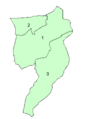
Map showing the three parishes of the liberty in 1881
