
Wennington, London facts for kids
Quick facts for kids Wennington |
|
|---|---|
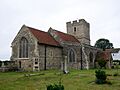
 Church of St Mary and St Peter |
|

Wennington
|
|
| Population | 300 (approximate) |
| OS grid reference | TQ540809 |
| • Charing Cross | 14.8 mi (23.8 km) E |
| London borough | |
| Ceremonial county | Greater London |
| Region | |
| Country | England |
| Sovereign state | United Kingdom |
| Post town | RAINHAM |
| Postcode district | RM13 |
| Dialling code | 01708 |
| Police | Metropolitan |
| Fire | London |
| Ambulance | London |
| EU Parliament | London |
| UK Parliament |
|
| London Assembly |
|
Wennington is a small village located in east London. It is part of the London Borough of Havering. The village is about 14.8 miles (23.8 km) east of central London.
Wennington used to be a very old parish in the county of Essex. It was officially changed in 1934. Today, it is surrounded by green spaces. Wennington became part of Greater London in 1965.
Contents
History of Wennington
Wennington is a very old place. It was first written about in the Domesday Book in 1086. Back then, it was called Wemtuna. Only a few families lived there.
.jpg)
The local church, St Mary and St Peter's, is very old. It was built in the 1100s. The area around Wennington included the Wennington Marshes and a place called Coldharbour.
Over time, the way Wennington was governed changed. In 1934, it became part of a larger area called Hornchurch Urban District. Later, in 1965, Hornchurch Urban District was removed. Wennington then became part of the London Borough of Havering in Greater London.
The 2022 Wildfire
On July 19, 2022, Wennington faced a big challenge. A wildfire spread through the village. This happened during a very hot summer in the UK.
The fire burned down at least 18 houses. Many other homes were also damaged. About 90 families had to leave their homes for safety. Firefighters from the London Fire Brigade worked hard to put out the flames. The fire reportedly started from a compost heap.
Geography of Wennington
Wennington village stretches out along Wennington Road (B1335). It is close to the A13 road. The village is about 2 kilometers (over 1 mile) north of the River Thames.
Most of Wennington has scattered houses. It also has the Wennington Hall farmhouse. Around 300 people live in the village. To the south of Wennington are the Wennington Marshes. These marshes are now part of the Rainham Marshes nature reserve. This is a special place for wildlife.
Wennington shares borders with other areas. To the west and north is Rainham. To the south, across the Thames, is Erith in the London Borough of Bexley. To the east are Aveley and Purfleet in Thurrock.
Getting Around Wennington
Public Transport
You can get to Wennington using London Buses route 372.
Nearest Train Stations
- Rainham railway station
- Purfleet railway station
Images for kids
-
Church of St Mary and St Peter
