
River Cherwell facts for kids
Quick facts for kids Cherwell |
|
|---|---|

The Cherwell at Magdalen Bridge, Oxford
|
|
| Country | England |
| Counties | Northamptonshire, Oxfordshire |
| Towns | Banbury |
| Physical characteristics | |
| Main source | Hellidon, Daventry, Northamptonshire 179 m (587 ft) 52°12′23″N 1°14′49″W / 52.20639°N 1.24694°W |
| River mouth | River Thames Oxford, Oxfordshire 56 m (184 ft) 51°44′32″N 1°14′54″W / 51.74222°N 1.24833°W |
| Length | 40 mi (64 km) |
| Discharge (location 2) |
|
| Discharge (location 3) |
|
| Basin features | |
| Basin size | 943 km2 (364 sq mi) |
| Tributaries |
|
The River Cherwell is a river in central England. It flows into the famous River Thames. The Cherwell starts near Hellidon, Northamptonshire. It then flows south for about 40 miles (64 km). It joins the Thames in Oxford, Oxfordshire.
The river is so important that it gives its name to a local government area. It also names Cherwell, a newspaper for students at Oxford University.
| Top - 0-9 A B C D E F G H I J K L M N O P Q R S T U V W X Y Z |
How to Say "Cherwell"
People living near Oxford often say "Char-well". This pronunciation is common in north Oxfordshire too. The village of Charwelton is named after the river. It is further upstream in Northamptonshire. This shows that people have said the name in different ways for a long time.
River Cherwell: Its Journey
The River Cherwell drains an area of 943 square kilometers (364 square miles). It is the second largest river that flows into the River Thames. Only the River Kennet is bigger.
Where the River Starts

The Cherwell is the most northern river that flows into the Thames. It begins in the ironstone hills at Hellidon. This is about 2 miles (3 km) west of Charwelton. A hill called Helidon Hill is just north of here. It acts like a giant natural wall. On one side, the Cherwell flows south towards the Thames. The Thames then flows into the North Sea. On the other side, the River Leam flows into the River Avon. The Avon then joins the River Severn, which flows into the Bristol Channel.
Another small stream that feeds the Cherwell starts east of Charwelton. Nearby, other rivers like the River Nene and River Great Ouse also begin. These rivers flow into the North Sea too.
South of Charwelton, the Cherwell flows between the villages of Hinton and Woodford Halse. A few miles further, the river turns west. It passes below the village of Chipping Warden. It also flows through Edgcote, where an old Romano-British villa once stood. The river then enters Oxfordshire at Hay's Bridge. This bridge is on the A361 road, which goes from Daventry to Banbury.
Cropredy and the Oxford Canal
About half a mile north of Cropredy village, the Cherwell turns south again. The Oxford Canal joins the valley here. It follows the river closely on its way to Oxford. The canal connects the Coventry Canal to the Thames. A law allowing the canal to be built was passed in 1769. Years before, people in Oxford wanted to make the river suitable for boats all the way to Banbury.
Building the canal started near Coventry. The canal reached Banbury in 1778. But it took 12 more years for the last part to be finished. The first boats arrived in Oxford in January 1790.
The Cherwell flows along the east side of Cropredy. It passes under Cropredy Bridge. This bridge was the site of a big battle in the English Civil War in 1644. King Charles's army fought and defeated the Parliamentarian army here. A plaque on the bridge says: "Site of the Battle of Cropredy Bridge 1644. From Civil War deliver us." The bridge was rebuilt in 1780. The plaque is a copy of the original. Cropredy's church has items from the battle. People in the area say that locals hid the church's eagle lectern in the Cherwell. They did this to protect it from soldiers.
South of the bridge, the river flows through fields. These fields are used for the annual Cropredy Festival. This is a three-day music event run by the band Fairport Convention. The river then passes an old watermill. This mill used a weir to create a millpond and a mill race. This was the first major mill on the river. Older, simpler mills might have existed further upstream.
Banbury's River History
After a few miles, the Cherwell flows under the M40 motorway. It then enters the industrial area of Banbury. This town is built around the river. Another old mill site is here. From Banbury, a main railway line runs alongside the river on its west side. This line was built by the Great Western Railway. It connects London and Oxford with Birmingham and the north. South of Banbury, the railway follows the river valley closely.
An old Roman villa was found at nearby Wykham Park. It dates back to around the year 250. Much later, the Saxons built the first settlement in Banbury. It was west of the river. On the other side of the river is Grimsbury. This was also started by the Saxons and is now part of Banbury.
Banbury Castle was built in 1135. It was built to control the river and the valley. The castle was made bigger and rebuilt many times. During the Civil War, it became a stronghold for the King's army (the Royalists). It was attacked in the winter of 1644–1645. A second attack started in January 1646. It lasted until April when the castle surrendered. The castle was pulled down in 1648.
A large water mill used to grind grain near the castle. The old brick mill building and the miller's house have been updated. They are now Banbury's main theatre and arts center.
South of Banbury
South of Banbury, the river valley becomes wider. On the west side is a large group of houses called Cherwell Heights. These were built in the 1970s. A mile south is the old village of Bodicote. It sits on high ground west of the river. Further downstream, most villages in the valley are built away from the river. This allows for flood-meadows, which are fields that can flood safely.
After Bodicote, the river passes an industrial area at Twyford Mill. It then reaches King's Sutton. This village is known for its tall, rare spire that overlooks the river. At Kings Sutton, the Sor Brook and Mill Lane brook join the Cherwell. Two miles further, the Cherwell reaches a place called Nell Bridge. It flows under a main road that leads to Aynho. Aynho is a village about a mile east, on a low hill overlooking the river.
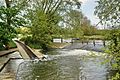
Soon after, the Oxford Canal crosses the Cherwell at a right angle. The canal flows into the river from the east. It then flows out over a weir. These types of river crossings are rare in England. A few yards below, the canal has Aynho Weir Lock. This lock is unusual because it is wide and diamond-shaped. It lowers the canal by about 12 inches (30 cm). This shape helps to quickly refill the water used by boats going through locks below.
Near the weir, an older railway line continues down the valley to Oxford. East of it, a more direct railway route opened in 1910. This route goes via Bicester and High Wycombe to London. The Cherwell used to provide water for the steam engines on the Oxford route. It fed long troughs between the rails. Engines could scoop up water from these troughs while moving slowly.
Lower Course: Villages and Gardens

From Aynho, the Cherwell winds its way through the landscape. Villages like Somerton and Heyford sit on hilltops overlooking the river. Somerton and Lower Heyford are the only villages right next to the river. Both once had water mills. The mill at Lower Heyford was mentioned in the Domesday Book in 1086. It was last rebuilt in the early 1800s and stopped milling in 1946.
At Rousham, the river flows past a famous landscape garden. This garden was designed by William Kent. It has many statues and a copy of an old Roman "temple." This temple overlooks the river. The river terrace here is called the Praeneste. It is named after a temple in Palestrina near Rome.
Two miles south, a medieval packhorse bridge crosses the river at Northbrook. A mile further south, the river crosses the path of Akeman Street, an old Roman road. South of here, the valley gets narrower and has more trees.
The Cherwell flows under the road that goes from Woodstock to Bicester. Soon after, the Oxford Canal flows into the river from the east. For about 1 mile (1.6 km), boats use this part of the river as part of the canal. It passes a cement works that used to get supplies by canal narrowboat. This factory also used water from the river.
After sharing their path for a short while, the river and canal separate. This happens at Shipton Weir Lock. West of this lock is Shipton on Cherwell. East of Shipton, the deserted village of Hampton Gay used to be along the river. All that remains are its old church in the watermeadows and the ruins of a manor house.
Further downstream, the river reaches Thrupp. Here, the Oxford Canal finally leaves the Cherwell valley. In the hills to the east, a Roman-British settlement once stood near Kidlington. Another Roman villa was in a parish on the west bank, Islip. To the east of Islip is a wide plain called Otmoor. This area is drained by the River Ray, which is the largest river that flows into the Cherwell. The Ray joins the Cherwell at a weir in Islip, known as The Stank.
The City of Oxford


The Cherwell reaches the northern edge of Oxford. It then flows south along the eastern side of the city center. Near Summertown, it passes the Victoria Arms pub. This pub is by the river in Marston. The river then flows under a modern bridge, which is part of Marston Ferry Road. A little further south, it passes Wolfson College. This is a college for graduate students at Oxford University. It also passes the Cherwell Boathouse, where you can rent punts. The playing fields of the Dragon School are also here. Next is Lady Margaret Hall, which was one of the first colleges for women.
The river then flows next to Oxford University Parks. It passes under Rainbow Bridge. Below the Parks, the river splits into up to three streams, forming several islands. One of these is Mesopotamia. This is a long, thin island just south of the Parks. It has a beautiful path lined with trees. At the north end of Mesopotamia, there are punt rollers next to a weir. St Catherine's College is on the largest island formed by the river splitting. The river also flows past Magdalen College.
The river comes together again into two close streams. These flow under Magdalen Bridge. On May Morning, students sometimes jump off this bridge. This is a dangerous tradition, especially if the river water is low. The river then splits again. To the west is the Oxford Botanic Garden. To the east are Magdalen College School and St Hilda's College. The river then flows around Christ Church Meadow. Finally, it flows into the River Thames (also called the Isis in Oxford) through two branches. The island between these branches has the main boathouses for rowing teams from the colleges.
Punting is a popular activity on the Oxford part of the river in spring and summer. A punt is a long, flat-bottomed boat. It is moved by pushing a long pole against the river bed. You can usually rent punts from a punt station near Magdalen Bridge or the Cherwell Boathouse. It is possible to punt all the way from the Isis, north past the University Parks, and even beyond the Oxford Ring Road.
The Withywindle river in J. R. R. Tolkien's fantasy world of Middle-earth is thought to be based on the Cherwell. Tolkien lived near Oxford.
The lowest part of the river was settled very early. The Cherwell was known as the border between two ancient Celtic tribes. These were the Dobunni to the west and the Catuvellauni to the east. These tribes were recorded when the Romans arrived.
At Oxney, Oxford, a Roman-British settlement grew. It was naturally protected from attacks by the large rivers. This settlement became very important for making pottery. They sent their pottery all over central southern England using boats on the Thames and its rivers.
When the Thames enters Oxford, its average flow rate is about 17.6 cubic meters per second. After the Cherwell joins it, the Thames's flow rate increases to about 24.8 cubic meters per second.
Boating on the Cherwell
The Cherwell river itself has never been easy to travel on by boat. In the 1600s, there were fewer weirs. Goods seemed to be carried up to Banbury in small, flat-bottomed boats. A test was done in 1764 where a load of coal was taken up the river. Since the Oxford Canal opened in 1790, only a few parts of the river are suitable for boats. These parts are mainly used by canoes and punts.
Images for kids
-
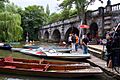
The Cherwell at Magdalen Bridge, Oxford
-
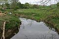
The River Cherwell near Edgcote, Northamptonshire
-
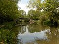
View upstream as the River Cherwell (flowing under the bridge) is joined by the Oxford Canal (coming from the right)
-
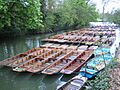
Punts on the river at Oxford
-
The punt rollers at "Mesopotamia" on the River Cherwell in Oxford
