
Oxford Canal facts for kids
Quick facts for kids Oxford Canal |
|
|---|---|

The Oxford Canal viewed from Napton-on-the-Hill
|
|
| Country | United Kingdom |
| Specifications | |
| Length | 126 km (78 miles) |
| History | |
| Current owner | Canal and River Trust |
| Principal engineer | James Brindley and Samuel Simcock |
| Date of act | 1769 |
| Date completed | 1 January 1790 |
| Geography | |
| Start point | Oxford |
| End point | Bedworth |
The Oxford Canal is a narrow canal in central England. It is about 126 kilometers (78 miles) long. This waterway connects the city of Oxford with Bedworth, which is near Coventry and Nuneaton. It also passes through towns like Banbury and Rugby.
The canal was finished in 1790. It links to the River Thames in Oxford. For about 8 kilometers (5 miles), it runs alongside the Grand Union Canal near Braunston and Napton-on-the-Hill. The Grand Union Canal later became more important for trade.
For about 15 years, the Oxford Canal was the main route for trade between the Midlands and London. It was very important for the local areas it passed through. Today, the canal is mostly used for fun. People enjoy taking narrowboats on holidays and weekend trips.
The Oxford Canal goes through Oxfordshire, Northamptonshire, and east Warwickshire. It flows through wide, shallow valleys and gentle hills. This scenery is similar to other canals like the Grand Union Canal. Along its route, you can find many wharves (places where boats load and unload) and public houses (pubs). The northern part of the canal, from Napton, is part of the popular Warwickshire ring waterway. In Oxford, the canal forms a water loop called the Four Rivers.
Contents
Exploring the Oxford Canal Route

.png)
The canal starts in Warwickshire near Hawkesbury Village. This spot is called Hawkesbury Junction, or Sutton Stop. Here, it connects with the Coventry Canal. This is about 7 kilometers (4 miles) from the center of Coventry. It is also about 8 kilometers (5 miles) from Nuneaton. Close by, the town of Bedworth had coal mines in the past. From Hawkesbury, the canal goes southeast for about 24 kilometers (15 miles) to Rugby.
Flat Sections and Tunnels
The part of the canal between Coventry and Rugby is mostly flat. It has no locks, except for a special "stop lock" at the junction. Locks are like water elevators that help boats move up or down hills. Some parts of this section were made straighter in the 1820s. You can still see bits of the older, curvier route in some places.
The canal winds through the northern part of Rugby. It goes through the Newbold Tunnel, which is about 247 meters (270 yards) long. In the churchyard at Newbold-on-Avon, you can see parts of an even older canal tunnel from the 1770s. East of Rugby, the canal goes up a series of three locks at Hillmorton. These are about 5 kilometers (3 miles) southeast of the town.
Journey Through the Countryside
East of Rugby, the canal turns southwest and then south. It goes under the M45 motorway. It passes through wide, low fields with views of wooded hills in Northamptonshire and Warwickshire. Eventually, it reaches Braunston.
Near Braunston village, the Oxford Canal meets the Grand Union Canal. Both canals then turn west-southwest. The Grand Union Canal has a large boatyard called Braunston Marina nearby. The combined canal splits north of Napton-on-the-Hill:
- The Oxford Canal goes southwest, then turns south towards Oxford through Banbury.
- The Grand Union Canal goes north, then northwest to Birmingham through Warwick.
After curving around Napton Hill, the canal goes up the Napton flight of nine locks. This takes it to a high section, but still below the hilltop. After passing an old wharf and a pub at Fenny Compton, the canal enters a long cutting. This used to be a tunnel in the 1800s. This part is often called a "tunnel straight."
The route between Priors Hardwick and Fenny Compton is very winding. It takes about 9 kilometers (5.6 miles) to cover a straight distance of only 3.5 kilometers (2.2 miles). This is the highest part of the canal for boats. It is known as the "eleven-mile pound."
The canal then goes down the Claydon flight of locks. It enters the valley of the young River Cherwell at Cropredy. From there, the canal follows the valley down to Oxford.

Banbury and Oxford Connections
Banbury has many places for visitors to moor their boats. These are right next to the old and new shopping areas in the town center. Banbury's local councils see the canal as a great attraction. For example, an old boatyard, Tooley's Historic Boatyard, is now part of the town center. About 6 kilometers (4 miles) south is Twyford Wharf. Here, narrowboats up to 18 meters (60 feet) long can turn around. Two nearby villages, Kings Sutton and Adderbury, are a short walk away and have pubs.
In Oxford, the canal connects to the River Thames in two places:
- About 5 kilometers (3 miles) north of the city, Dukes Cut leads to King's Lock.
- A short distance from the city center, near Oxford railway station, below Isis Lock. This path, called Sheepwash Channel, leads to a navigable loop on the Thames called "Four Rivers."
The Oxford Canal officially ends abruptly at Hythe Bridge Street. This is near the current Hythe Bridge over the Castle Mill Stream. The canal used to continue further, with a turning basin and goods wharf. It then went under Worcester Street to a coal wharf. In 1951, these areas were filled in. Nuffield College now stands on part of the old site.
Locks on the Oxford Canal
Here is a list of the locks on the Oxford Canal and how much they raise or lower the water level:
| Lock Number | Name | Rise of lock |
|---|---|---|
| 1 | Hawkesbury Lock (to/from Coventry Canal) | 0.3 m (1 ft 0 in) |
| 2–7 | Hilmorton Locks | 5.66 m (18 ft 7 in) |
| 8–16 | Napton Bottom Lock to Napton Top Lock | 14.96 m (49 ft 1 in) |
| 17–21 | Claydon Top Lock to Claydon Bottom Lock | 9.3 m (30 ft 6 in) |
| 22 | Elkington's Lock | 1.96 m (6 ft 5 in) |
| 23 | Varney's Lock | 1.78 m (5 ft 10 in) |
| 24 | Broadmoor Lock | 2.21 m (7 ft 3 in) |
| 25 | Cropredy Lock | 1.68 m (5 ft 6 in) |
| 26 | Slat Mill Lock | 2.44 m (8 ft 0 in) |
| 27 | Bourton Lock | 1.96 m (6 ft 5 in) |
| 28 | Hardwick Lock | 2.29 m (7 ft 6 in) |
| 29 | Banbury Lock | 1.78 m (5 ft 10 in) |
| 30 | Grant's Lock | 2.9 m (9 ft 6 in) |
| 31 | King's Sutton Lock | 3.25 m (10 ft 8 in) |
| 32 | Nell Bridge Lock | 2.64 m (8 ft 8 in) |
| 33 | Aynho Weir Lock | 0.3 m (1 ft 0 in) |
| 34 | Somerton Deep Lock | 3.66 m (12 ft 0 in) |
| 35 | Heyford Common Lock | 2.18 m (7 ft 2 in) |
| 36 | Allen's Lock | 1.52 m (5 ft 0 in) |
| 37 | Dashwood Lock | 2.82 m (9 ft 3 in) |
| 38 | Northbrook Lock | 1.52 m (5 ft 0 in) |
| 39 | Pigeon Lock | 2.54 m (8 ft 4 in) |
| 40 | Baker's Lock | 2.59 m (8 ft 6 in) |
| 41 | Shipton Weir Lock | 0.74 m (2 ft 5 in) |
| 42 | Roundham Lock | 2.26 m (7 ft 5 in) |
| 43 | Kidlington Green Lock | 1.45 m (4 ft 9 in) |
| 44A | Duke's Lock | 1.63 m (5 ft 4 in) |
| 44B | Duke's Lock (to/from the Thames via Duke's Cut) | |
| 45 | Wolvercote Lock | 1.12 m (3 ft 8 in) |
| 46 | Isis Lock (to/from the Thames via Sheepwash Channel) | 1.07 m (3 ft 6 in) |
The canal goes up from Hawkesbury Junction to Hilmorton Top Lock. Then there's a flat section about 10.5 kilometers (6.5 miles) long to Braunston Junction. Here, it joins the Grand Union Canal. From Napton Junction, the Oxford Canal goes up again through the Napton Locks. After Napton Top Lock, there is another flat section about 17 kilometers (10.5 miles) long to Claydon Top Lock. From there, the canal goes downhill towards Oxford.

History of the Oxford Canal
Building the Canal
The Oxford Canal was built in several steps. It took more than twenty years to complete.
In 1769, a special law was passed by Parliament to allow the Oxford Canal to be built. Sir Roger Newdigate, a Member of Parliament, led the company that built the canal. The goal was to connect the busy factories of the Midlands to London using the River Thames. Building started soon after near Coventry.
The famous engineer James Brindley first planned the route and oversaw the building. His brother-in-law, Samuel Simcock, helped him. Brindley passed away in 1772, but Simcock took over and finished the canal. By 1774, the canal had reached Napton, but the company was running out of money.
In 1775, a second law was passed to let the company raise more money. Building started again, and by 1778, the canal had reached Banbury. Money problems meant that work on the last part to Oxford didn't begin until 1786.
The section from Banbury to Oxford was built as cheaply as possible. They saved money in many ways. They used wooden lift or swing bridges instead of expensive brick ones. They also used deep locks with single gates at each end, which were cheaper than double gates.
A part of the River Cherwell at Shipton-on-Cherwell was included in the canal. This saved money on building, but the river's natural flow made the canal harder to use. This was a mistake that still affects the canal today.
The Oxford Canal reached the edge of Oxford in 1789. A coal wharf (a place to load and unload coal) was opened there. The final part into central Oxford officially opened on January 1, 1790.
Canal's Busy Years
For the next 15 years, the Oxford Canal became one of Britain's most important and profitable transport routes. Most trade between London and the Midlands used this canal. Its main cargo was coal from Warwickshire. It also carried stone, farm products, and other goods.

In 1805, a more direct route, the Grand Junction Canal, was completed. Much of the traffic going to London switched to this faster route. This was because it avoided the River Thames, which had many old-fashioned "flash locks." This greatly reduced traffic on the Oxford Canal south of Napton. However, the short section between Braunston and Napton became a key link. It connected the Warwick and Napton Canal to the Grand Junction Canal, making it part of the busy route between Birmingham and London.
The Grand Junction and Oxford canal companies were rivals. When Parliament discussed building the Grand Junction, the Oxford Canal successfully asked for "bar tolls." These were payments from the Grand Junction to make up for lost traffic south of Napton.
Boats from Birmingham had to use about 8 kilometers (5 miles) of the Oxford Canal. This was to get from Braunston to the Grand Junction at Napton. The Oxford Canal took advantage of this by charging high tolls for Grand Junction traffic on this short part.
The Oxford Canal was first built as a "contour canal." This means it curved around hills to stay on a level path. But in 1827, Mr. Brunel (a famous engineer) re-surveyed the northern part of the canal. This was between Braunston and Hawkesbury Junction. The goal was to straighten it and make travel faster. This work, done between 1830 and 1834, shortened the distance by about 23.7 kilometers (14.75 miles). The section south of Napton was never straightened.
The straightening work made the three locks at Hillmorton very busy. These were the first locks after the stop lock at Hawkesbury Junction. To solve the traffic jams, they built a second, parallel lock next to each existing one at Hillmorton. This created three pairs of two narrow locks. It allowed twice as many boats to pass through at once. This work was finished in August 1840. Not only did it double the capacity, but it also made the process faster. Tests showed locks could be used in as little as 1 minute 20 seconds.
In 1833, a new type of boat was tested on a section of the canal near Dunchurch. This boat, named Swallow, was made of wrought iron. Pulled by two horses, it traveled 2.4 kilometers (1.5 miles) in 7 minutes and 35 seconds. This was a speed of almost 19 kilometers (12 miles) per hour!
The northern part of the Oxford Canal, from Coventry to Braunston and Napton, stayed an important route. It was very busy with freight until the 1960s. The main cargo was coal from the Warwickshire and Leicestershire coalfields. This coal went to London via the Grand Union Canal. However, the southern part from Napton to Oxford became less busy. It mostly carried local goods.

Decline and Revival
In 1937, Baron Nuffield bought the canal basin in Oxford. In 1951, he filled it in and built Nuffield College on part of the old coal wharf. Coal traffic moved to a new wharf in Juxon Street, in Jericho, Oxford. The old goods wharf and the rest of the coal wharf are now a public car park.
The Oxford Canal stayed independent until the government took it over in 1948. It became part of the British Waterways system.
Many boatmen and women on the Oxford Canal kept using horses to pull their narrowboats. This was long after other canals switched to diesel engines. One narrowboat carrying coal on the Oxford Canal was pulled by a mule until 1959. This was the last horse-drawn freight narrowboat in Great Britain. This boat, named Friendship, is now kept at the National Waterways Museum, Ellesmere Port.
The Oxford Canal made money until the mid-1950s. Like most of Britain's narrow canals, the Oxford Canal saw a fast drop in freight traffic after the Second World War. By the mid-1950s, very few narrowboats traded south of Napton. The southern section was even threatened with closure. However, the northern section (Napton to Coventry) remained busy with commercial traffic until the 1960s.
During the 1960s, pleasure boating became popular. People started using boats for fun instead of just for trade. After a trip on the canal, Barbara Castle, who was the Minister for Transport, decided not to close the canal.
Today, the canal is very lively. In the summer, it is one of the busiest canals in the whole network.
Oxford Canal Walk for Hikers
The towpath next to the canal is a great place for walking. It forms the 132-kilometer (82-mile) Oxford Canal Walk. This walk includes an 8.8-kilometer (5.5-mile) extension from Hawkesbury Junction to Coventry on the Coventry Canal towpath. A 16-kilometer (10-mile) part from Oxford to Kirtlington is also part of the European walking route E2. The Canal Walk is popular with people who enjoy Geocache activities. Many Geocache sites are located along the canal.
Images for kids
-
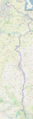
Geographic map of the Oxford Canal (zoom in to see detail)
