
Coventry Canal facts for kids
The Coventry Canal is a cool waterway in the middle of England. It's like a long, narrow river made by people!
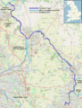
It starts in the city of Coventry. Then, it travels about 38 miles (61 km) north to a place called Fradley Junction, near Lichfield. There, it connects with another big canal, the Trent and Mersey Canal. The Coventry Canal also links up with other canals like the Ashby Canal, the Birmingham and Fazeley Canal, and the Oxford Canal.
Sometimes, maps show this canal in two parts. They might say a middle section belongs to the Birmingham and Fazeley Canal. But the people who look after the canals today, the Canal & River Trust, say the whole route is the Coventry Canal. This is because of some old money troubles and ownership changes when the canal was being built a long time ago.
The canal passes through or near towns like Bedworth, Nuneaton, Atherstone, Polesworth, and Tamworth. Boats up to 72 feet (21.9 m) long can use it. It's also part of a popular boating route called the Warwickshire ring.
Contents
Exploring the Canal Route

The canal adventure begins at the Coventry Canal Basin. This basin was opened way back in 1769 and made bigger in 1788. It's just north of Coventry city centre. Many of the old buildings here were fixed up between 1993 and 1995. The Canal Bridge, Canal House, and the old warehouses are special historic buildings. Every boat entering or leaving the basin has to go under the Canal Bridge.
From the basin, the canal winds its way north through Coventry. It goes under many road bridges, including some cool hump-back bridges under Foleshill Road and Longford Road.
About five miles (8 km) north of Coventry, you'll find Hawkesbury Junction. Here, an amazing old iron bridge crosses the start of the Oxford Canal. The Oxford Canal heads south towards the River Thames in Oxford. At Hawkesbury Junction, you can see old buildings from when the canal was super busy. There's even a traditional pub, the Greyhound, where boaters often stop. This spot is also known as Sutton Stop, named after a small lock nearby on the Oxford Canal.
A few miles north of Hawkesbury, near Bedworth, is Marston Junction. This is where the Ashby Canal begins. The Ashby Canal is a peaceful, rural route with no locks. It used to go to old coal mines, but now you can only travel about 22 miles (35 km) along it to Snarestone.
From Marston Junction, the Coventry Canal continues north-west. It goes through Nuneaton, Atherstone, and Polesworth, all the way to Tamworth. At Atherstone, there's a set of 11 locks, from Top Lock No. 1 to Atherstone Bottom Lock No. 11. These locks lower the canal's water level by 80 feet (24 m) as it heads towards Polesworth. The only other locks on the Coventry Canal are the two Glascote locks. They lower the water level another 13 feet 8 inches (4.17 m) just before Fazeley Junction.
In a part of Tamworth, at Fazeley Junction, boaters can turn south. This route takes them towards Birmingham along the Birmingham and Fazeley Canal.
The Coventry Canal keeps going north until it reaches its end at Fradley Junction. There, it connects with the Trent and Mersey Canal. For a while, between Fazeley and halfway to Fradley, some maps used to call this part the "Birmingham and Fazeley Canal."
A Look at Canal History
The company that built the Coventry Canal was started in 1768. A famous engineer named James Brindley was hired to build it, and work began in December of that year. Brindley wanted the canal to be built to very high standards. Because of this, the company ran out of money by 1769, when the canal had only reached Atherstone. So, Brindley was replaced by another engineer, Thomas Yeoman.
Later, in 1784, Thomas Dadford gave advice on building the canal's bridge over the River Tame, which is now called Tame Aqueduct. In June 1785, Thomas Sheasby was given the job of connecting the Coventry Canal to the Trent and Mersey Canal.
Even though the canal reached the Birmingham and Fazeley Canal at Fazeley, the very last part, approved by Parliament to go to the Trent and Mersey at Fradley, wasn't finished until 1789.
The Trent and Mersey company and the Birmingham and Fazeley company really wanted boats to be able to travel all the way between Birmingham and the Trent and Mersey Canal. So, they got permission to finish the unbuilt section from Fazeley to Fradley. The Birmingham and Fazeley company built north from Fazeley, and the Trent and Mersey company built south from Fradley. The entire canal, from Coventry to Fradley, was finally opened in 1789.
The Coventry Canal company later bought the northern part of this section. But the middle part stayed owned by the Birmingham and Fazeley Canal. This is why some maps still show that middle section as the Birmingham and Fazeley Canal. However, the Canal & River Trust, who manage the canal today, say the whole route from Coventry to the Trent and Mersey Canal is the Coventry Canal.
How the Canal Was Used
The Coventry Canal was a super important route for trade for many years. It was part of a big route from Birmingham to London. Boats would use the Birmingham and Fazeley Canal, then the Coventry Canal, then the Oxford Canal, and finally the River Thames.
Even when a new, more direct route from Birmingham to London opened, the Coventry Canal still had lots of trade. This was partly because the Oxford Canal company made its route shorter, and also because the new route had high fees on one section.
The Coventry Canal company made money right up until 1947. It has stayed open for boats to this day! Today, the canal is a very popular place for narrowboat trips. Many visitors rent narrowboats to explore the area and see its history.
In 1948, the canal became owned by the government. It was first run by the British Transport Board, and then by the British Waterways Board.
In 1957, the Coventry Canal Society was started. This group works to help use and take care of the canal, and to protect it. A group called Mercia Canoe Club also uses the canal as its home base.
Gallery
- Photos On The Route
-
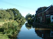
Coventry Canal near Fradley
-
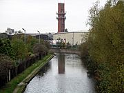
Viewed looking west from Foleshill Rd, near Matlock Rd.
-
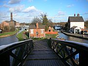
Hawkesbury Junction
-
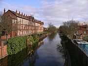
View to the north from Cash's Lane Bridge, Coventry.


Images for kids
-
Geographic map of the Coventry Canal (zoom in to see detail)

