
Birmingham and Fazeley Canal facts for kids
Quick facts for kids Birmingham and Fazeley Canal |
|
|---|---|

The cool footbridge and swing bridge near Drayton Bassett.
|
|
| Specifications | |
| Locks | 44 |
| Status | Navigable |
| Navigation authority | Canal & River Trust |
| History | |
| Original owner | Birmingham and Fazeley Canal Company |
| Principal engineer | John Smeaton |
| Date of act | 1784 |
| Date completed | 1789 |
| Geography | |
| Start point | Fazeley Jn, Coventry Canal |
| End point | Old Turn Jn, BCN Main Line |
| Connects to | BCN Main Line, Coventry Canal, Grand Union Canal, Tame Valley Canal |
The Birmingham and Fazeley Canal is a canal in the West Midlands of England. It is part of the Birmingham Canal Navigations network. This canal was built to link the city of Birmingham with the Coventry Canal. This connection then allowed boats to travel to London using the Oxford Canal. It was a very important route for moving goods.
History of the Birmingham and Fazeley Canal
The idea for the Birmingham and Fazeley Canal started in 1770. At that time, the Birmingham Canal Company had a lot of control over canal routes. People wanted a new canal to connect the coalfields near Walsall to the wider canal network.
Early Plans and Challenges
In 1781, a plan for a canal from Wednesbury to Atherstone was suggested. Atherstone was where the Coventry Canal ended back then. The Birmingham Canal Company saw this new plan as a threat.
In 1782, two different plans for canals were presented to Parliament. One was for the Birmingham and Fazeley Canal. The other was from the Birmingham Canal Company. Both companies opposed each other's plans, and neither bill passed.
Working Together for a Bigger Network
After this, the people behind the Birmingham and Fazeley Canal talked with other canal companies. They wanted to make sure their canal would be part of a larger system. In 1782, they made agreements with the Oxford Canal Company and the Coventry Canal Company. The Oxford Canal Company agreed to finish their route to the River Thames. The Coventry Canal Company agreed to extend their canal to Fazeley.
The Birmingham and Fazeley Canal Company also agreed to help finish the Coventry Canal's route. This was because the Coventry Canal Company did not have enough money. The Trent and Mersey Canal Company would build the final part of the link.
Parliament's Approval and Company Merger
A second bill was put before Parliament. The Birmingham and Fazeley Canal was finally approved in 1784. Soon after, the new company merged with the Birmingham Canal Company. Their new name was the Birmingham & Birmingham & Fazeley Canal Company. This name was a bit long and tricky! Later, in 1794, the name was changed to Birmingham Canal Navigations.
Building the Canal: Problems and Solutions
John Smeaton, a famous engineer, was in charge of building the canal. Work did not start right away. There were also disagreements between James Bough, the company's superintendent, and the contractors, Pinkertons. They argued about the quality of the cement being used.
Work on the Fazeley section began in April 1786. In late 1786, George Pinkerton found that the survey levels were wrong. Samuel Bull, the canal company's engineer, checked and agreed with Pinkerton.
The company stopped paying Pinkerton in late 1788 because costs were too high. Their contract was ended in February 1789. There was a long financial argument about money paid to Pinkerton. The case lasted for ten years.
The canal was finished in August 1789. When all the connecting canals were completed in 1790, a lot of goods started moving on the canal. This caused problems because the locks at Aston and Farmer's Bridge became very busy. This problem was fixed much later, in 1844. That's when the Birmingham and Warwick Junction Canal and the Tame Valley Canal opened.
Route of the Canal
The Birmingham and Fazeley Canal today runs for about 15 miles (24 km). It goes from Old Turn Junction in Birmingham to Fazeley Junction near Tamworth. Along this route, there are 38 locks.
Journey from Birmingham
From Old Turn Junction, 13 locks lower the canal's level. This section is called the Farmer's Bridge flight. After these locks, there is a flat part of the canal. A short branch, the Digbeth Branch Canal, runs from Aston Junction. It has 6 locks.
Below Aston Junction, there are 11 more locks, known as the Aston flight. The railway to Aston station crosses over the canal here. At Salford Junction, other canals meet: the Tame Valley Canal and the Grand Union Canal. The Fazeley Canal continues east from here.
Through Countryside to Fazeley
Two more locks are at Minworth. After this, the scenery changes from city buildings to open countryside. There is a short tunnel at Curdworth, about 57 yards (52 meters) long. After the tunnel, you can see fields and old gravel pits along the canal.
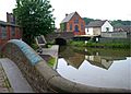
Near Drayton Bassett, there's a unique footbridge with Gothic-style towers. It's close to Drayton Manor Theme Park. Soon after, the canal reaches Fazeley, where it joins the Coventry Canal.
Beyond Fazeley Junction
The Birmingham and Fazeley Canal Company also built a 5.5-mile (8.9 km) section north of Fazeley Junction. This part goes to Whittington. The rest of the route to Fradley Junction was built by the Trent and Mersey Canal. Even though the Coventry Canal bought back the northern section, the southern part still belongs to the Birmingham and Fazeley Canal. However, people often think of this section as part of the Coventry Canal.
Historically, the canal started at Farmer's Bridge Top Lock. This was where it met the old Birmingham Canal Newhall Branch. That branch is now mostly built over, but Cambrian Wharf still exists.
The Birmingham and Fazeley Canal is also part of the famous Warwickshire ring, a popular route for canal boats.
Special Features Along the Way
At Common lock 10, you can find an interesting message carved into the stone. It says: "Pax Missa Per Orbem, Pax Quaeritur Bello". This means "Peace Is Sent Throughout The World, Peace Is Sought Through War". This saying comes from old coins.
| Point | Coordinates (Links to map resources) |
OS Grid Ref | Notes |
|---|---|---|---|
| Old Turn Junction | 52°28′45″N 1°54′50″W / 52.4792°N 1.9139°W | SP058868 | BCN Main Line |
| Stour Valley railway tunnel | 52°28′46″N 1°54′50″W / 52.4794°N 1.9138°W | SP058868 | Birmingham, Wolverhampton and Stour Valley Railway runs beneath canal |
| Farmer's Bridge Junction (original) | 52°28′50″N 1°54′45″W / 52.4806°N 1.9125°W | SP059870 | Junction with former Birmingham Canal Newhall Branch |
| Cambrian Wharf basin | 52°28′50″N 1°54′42″W / 52.4806°N 1.9118°W | SP059870 | |
| Newhall Branch (closed) | 52°28′51″N 1°54′40″W / 52.4808°N 1.9110°W | SP060870 | |
| Farmer's Bridge top lock 1 | 52°28′51″N 1°54′43″W / 52.4808°N 1.9120°W | SP059870 | |
| Farmer's Bridge lock 2 | 52°28′52″N 1°54′40″W / 52.4811°N 1.9110°W | ||
| Farmer's Bridge lock 3 | 52°28′53″N 1°54′36″W / 52.4813°N 1.9101°W | ||
| Farmer's Bridge lock 4 | 52°28′53″N 1°54′33″W / 52.4815°N 1.9092°W | ||
| Farmer's Bridge lock 5 | 52°28′55″N 1°54′30″W / 52.4820°N 1.9082°W | ||
| Farmer's Bridge lock 6 | 52°28′56″N 1°54′27″W / 52.4823°N 1.9076°W | ||
| Farmer's Bridge lock 7 | 52°28′57″N 1°54′25″W / 52.4826°N 1.9070°W | ||
| Whitmore Arm junction | 52°28′58″N 1°54′24″W / 52.4828°N 1.9067°W | dry | |
| Farmer's Bridge lock 8 | 52°28′58″N 1°54′23″W / 52.4829°N 1.9064°W | ||
| Farmer's Bridge lock 9 | 52°29′00″N 1°54′21″W / 52.4833°N 1.9057°W | Directly under Newhall Street | |
| Farmer's Bridge lock 10 | 52°29′01″N 1°54′18″W / 52.4837°N 1.9050°W | Directly under Brindley House | |
| British Telecom Tower | 52°29′01″N 1°54′15″W / 52.4835°N 1.9043°W | ||
| Farmer's Bridge lock 11 | 52°29′03″N 1°54′15″W / 52.4841°N 1.9043°W | ||
| Farmer's Bridge lock 12 | 52°29′06″N 1°54′10″W / 52.4851°N 1.9027°W | ||
| Birmingham Snow Hill station bridge | 52°29′07″N 1°54′08″W / 52.4854°N 1.9021°W | ||
| Farmer's Bridge bottom lock 13 | 52°29′09″N 1°54′04″W / 52.4859°N 1.9012°W | SP067875 | |
| Aston Expressway (Aston Road) | 52°29′25″N 1°53′22″W / 52.4903°N 1.8894°W | SP075880 | |
| Aston Junction | 52°29′25″N 1°53′19″W / 52.4902°N 1.8887°W | SP075880 | Digbeth Branch Canal |
| Aston top lock 14 | 52°29′25″N 1°53′18″W / 52.4904°N 1.8882°W | SP075881 | |
| Aston lock 15 | 52°29′27″N 1°53′14″W / 52.4908°N 1.8873°W | ||
| Aston lock 16 | 52°29′29″N 1°53′12″W / 52.4913°N 1.8866°W | ||
| Aston lock 17 | 52°29′30″N 1°53′09″W / 52.4918°N 1.8859°W | ||
| Aston lock 18 | 52°29′33″N 1°53′07″W / 52.4924°N 1.8853°W | ||
| Aston lock 19 | 52°29′34″N 1°53′05″W / 52.4929°N 1.8846°W | ||
| Aston lock 20 | 52°29′38″N 1°53′00″W / 52.4940°N 1.8833°W | ||
| Aston lock 21 | 52°29′41″N 1°52′57″W / 52.4946°N 1.8824°W | ||
| Aston lock 22 | 52°29′55″N 1°52′39″W / 52.4986°N 1.8774°W | ||
| Aston lock 23 | 52°30′02″N 1°52′24″W / 52.5005°N 1.8733°W | ||
| Aston bottom lock 24 | 52°30′13″N 1°52′16″W / 52.5035°N 1.8711°W | SP087895 | Cross-City Line |
| Salford Junction | 52°30′31″N 1°51′33″W / 52.5085°N 1.8591°W | SP095901 | Tame Valley Canal, Grand Union Canal |
| Factory over canal | 52°30′30″N 1°50′42″W / 52.5083°N 1.8449°W | SP105900 | 150 yards under factory buildings, open on one side |
| Erdington Hall Bridge | 52°30′29″N 1°50′36″W / 52.5081°N 1.8432°W | SP106900 | Original site of bridge |
| Minworth top lock | 52°31′21″N 1°47′45″W / 52.5225°N 1.7957°W | SP138916 | |
| Minworth middle lock | 52°31′31″N 1°47′25″W / 52.5252°N 1.7904°W | SP142919 | |
| Minworth bottom lock | 52°31′44″N 1°46′39″W / 52.5288°N 1.7775°W | SP150923 | |
| Curdworth Tunnel | 52°32′11″N 1°44′20″W / 52.5364°N 1.7389°W | SP177932 | |
| M6 Toll motorway bridge | 52°32′28″N 1°43′47″W / 52.5411°N 1.7296°W | SP183937 | |
| Curdworth top lock 1 | 52°32′29″N 1°43′44″W / 52.5413°N 1.7289°W | SP183937 | |
| Curdworth lock 2 | 52°32′44″N 1°43′18″W / 52.5456°N 1.7217°W | SP190942 | |
| Curdworth lock 3 | 52°32′47″N 1°43′14″W / 52.5463°N 1.7206°W | SP190943 | |
| Curdworth lock 4 | 52°32′50″N 1°43′11″W / 52.5472°N 1.7198°W | SP191944 | |
| Curdworth lock 5 | 52°32′54″N 1°43′08″W / 52.5482°N 1.7190°W | SP192945 | |
| Curdworth lock 6 | 52°33′01″N 1°43′03″W / 52.5502°N 1.7174°W | SP197947 | |
| Curdworth lock 7 | 52°33′16″N 1°42′50″W / 52.5544°N 1.7140°W | SP195952 | |
| Curdworth lock 8 | 52°33′37″N 1°42′36″W / 52.5603°N 1.7100°W | SP198959 | |
| Curdworth lock 9 | 52°33′45″N 1°42′33″W / 52.5625°N 1.7093°W | SP198961 | |
| Common Lock 10 | 52°34′04″N 1°42′23″W / 52.5678°N 1.7064°W | SP200967 | |
| Kigsbury swivel bridge | 52°34′23″N 1°42′13″W / 52.5731°N 1.7036°W | SP200973 | |
| Curdworth bottom lock 11 | 52°34′24″N 1°42′13″W / 52.5733°N 1.7035°W | SP202973 | |
| Aqueduct | 52°35′12″N 1°42′18″W / 52.5866°N 1.7051°W | SP199988 | Near Middleton Hall |
| Drayton swivel and ornamental bridges | 52°36′17″N 1°42′23″W / 52.6047°N 1.7065°W | SK198008 | |
| Fazeley Mill Marina | 52°36′36″N 1°42′12″W / 52.6100°N 1.7034°W | SK200014 | |
| Watling Street | 52°36′54″N 1°42′04″W / 52.6151°N 1.7012°W | SK202020 | |
| Fazeley Junction | 52°36′55″N 1°42′04″W / 52.6154°N 1.7010°W | SK202020 | Coventry Canal (to Coventry). Continues as de facto B&F to Whittington |
| Whittington Brook | 52°40′21″N 1°45′20″W / 52.6724°N 1.7556°W | SK165083 | Coventry Canal (detached part) to Huddlesford Junction |
Gallery
-
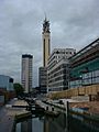
Part of the Farmer's Bridge flight looking towards the BT tower
-
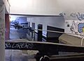
Underneath Brindley House, part of the BT Tower complex
-
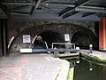
Farmer's Bridge Lock 9 and extended pound, running through two arches of the Newhall Street bridge in central Birmingham. There is a lock gate on either side of the road.
-
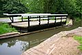
The Drayton swing bridge
-
The end of the Birmingham and Fazeley Canal under the Watling Street Bridge at Fazeley
-
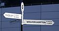
Fingerpost at Old Turn Junction, where the Birmingham and Fazeley Canal meets BCN Main Line


Images for kids
-
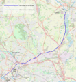
Geographic map of the canal (zoom in to see detail)

