
Tame Valley Canal facts for kids

The Tame Valley Canal is a special waterway built in 1844 in the West Midlands area of England. It's part of a bigger network called the Birmingham Canal Navigations. The canal gets its name because it runs close to the River Tame.
Contents
Where Does the Tame Valley Canal Go?
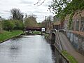
The canal starts at a place called Tame Valley Junction. Here, it connects with the Walsall Canal near Ocker Hill and Toll End. It then travels about 8.5 miles (13.7 km) until it reaches Salford Junction. At Salford Junction, it meets two other canals: the Birmingham and Fazeley Canal and the Grand Union Canal. The Tame Valley Canal is special because it has two towpaths along its whole length, one on each side!
Journey Through the Landscape
Between Tame Valley Junction and Rushall Junction, the canal goes under the West Midlands Metro (a tram line) near Wednesbury. It also crosses over an old railway line, now part of the Chase Line, using a special bridge called an aqueduct. This happens near Tame Bridge Parkway railway station. It's interesting because the railway was there before the canal in this spot!
The canal then passes over the M5 motorway near where it meets the M6 motorway (at junction 8). It also joins the Rushall Canal at Rushall Junction, which is right inside the triangle formed by the motorway junction. Further east, the canal goes under another part of the M5.
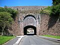
Near Hamstead, you can still see what's left of an old wharf. This was a place where boats would load and unload goods for the nearby Hamstead Colliery (a coal mine). Even further east, there are two more aqueducts: Spouthouse Lane Aqueduct and Piercy Aqueduct (which crosses over the Old Walsall Road). The canal also cuts through a deep section of 200-million-year-old sandstone near Tower Hill, passing under Freeth Bridge (which is now only for people walking or cycling). This part of the canal is at a high level, called the Walsall Level, and has no locks. However, it crosses over eight aqueducts in just five miles!
The Perry Barr Locks
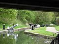
The canal then reaches the thirteen Perry Barr Locks, which start just after the A34 road. These locks help the canal drop down a total of 106 feet (about 32 meters)! The original houses where the lock keepers lived are still there.
Between the first and second locks, there's a special cast-iron footbridge called Perry Barr Locks Bridge. It was built in 1844 and is a Grade II listed building, meaning it's historically important.
Near the seventh lock, in Perry Park and close to Alexander Stadium, you'll find Perry Reservoir. This reservoir was finished in 1880 and helps feed water into the canal. It gets its water from Holbrook, a small stream that flows into the River Tame.
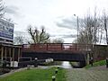
From there, the canal goes under the M6 motorway. It then continues down the rest of the Perry Barr locks. Between locks nine and ten, there used to be Perry Barr Wharf, but it's now filled in. The canal passes under the M6 two more times, including the famous Gravelly Hill Interchange (also known as Spaghetti Junction!). Soon after this, the canal ends at Salford Junction.
How the Canal Was Built

The idea for the canal was approved by a special law from Parliament in 1839. Building work then began, and the canal officially opened in 1844. The main person in charge of designing and building it was a famous engineer named James Walker.
Images for kids
-
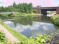
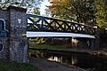
The start of the Tame Valley Canal at Tame Valley Junction.
-
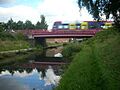
The Midland Metro tram line crossing above the Tame Valley Canal.
-
A bridge over the River Tame, near the canal.
-
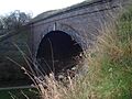
The Spouthouse Lane Aqueduct, carrying the canal over a road.
-
The historic Perry Barr Locks Bridge.
-
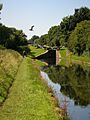
A heron spotted near the Tame Valley Canal.
-
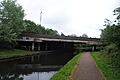
The M6 motorway crossing over the Tame Valley Canal.
-
Perry Barr Lock number 8.
-
The site of the old Perry Barr Wharf, near College Road Bridge.
-
College Road Bridge and Perry Barr Lock number 10.
-
Salford Junction, where the Tame Valley Canal meets other canals.


.jpg)
.jpg)
.jpg)

