
Walsall Canal facts for kids

The Walsall Canal is a cool waterway in the West Midlands, England. It's about 7 miles long and quite narrow, only 7 feet wide. This canal is part of a bigger network called the Birmingham Canal Navigations. It winds its way around the west side of the town of Walsall.
Contents
Exploring the Walsall Canal Route
The Walsall Canal starts at a place called Ryders Green Junction. Here, it connects with the Wednesbury Old Canal. Right away, the canal goes down through eight special water steps called Ryders Green Locks. These locks lower the boats to the Walsall Level, which is 408 feet high.
Further along, at Doe Bank Junction, the canal meets the Tame Valley Canal. There's also a very short branch here called the Ocker Hill Tunnel Branch. This part is now used for private boat parking. It used to help get water to pumps that kept the Wolverhampton Level full.
As the canal goes north, it passes under the West Midlands Metro line. You'll also see the short Bradley Branch at Moorcroft Junction. In this area, you might spot huge iron gates from the old Patent Shaft factory. Even though the factory closed in 1980, these gates are still there. They have been moved to a traffic island in Wednesbury.
The canal then passes the short Anson Branch. This branch once led to the Bentley Canal, which is no longer used. It also goes under the M6 motorway near junction 10. A very short part of the canal, called the Walsall Town Arm, leads right into Walsall town centre. The main canal then goes up through eight more locks. These locks lift boats up to meet the Wyrley and Essington Canal at Birchills Junction.
The canal starts at the Birmingham Level. It then goes down 45 feet to the Walsall Level. After that, it rises 65 feet to reach the Wolverhampton Level.
The History of the Walsall Canal
The Walsall Canal was built in four main steps over many years. It began as an extension to the Wednesbury Canal. This first part opened in 1785 to help transport coal from mines in Moxley. This section was planned as a separate part of the Birmingham & Fazeley Canal.
At the same time, from the other direction, the Birchills Branch of the Wyrley and Essington Canal reached Bloxwich Wharf by 1798. This was to the north-west of Walsall.
The company that owned the canals, then called the Birmingham, Birmingham and Fazeley Canal Company, got permission in 1794 to extend the canal. They wanted to build from Broadwaters all the way to Walsall. They were allowed to borrow £45,000 to build the canal and three smaller branches. These branches would help serve local iron and coal mines. They planned to finish everything within three years.
Building started at Broadwaters and reached Darlaston by May 1798. The second part of the building work began in April 1798. The digging was finished in 1799, but the whole project wasn't completed until 1800.
There was a small gap between the Birmingham Canal Navigations line and the Wyrley and Essington Canal's Birchills Branch. This was a problem for businesses north of Walsall, as it made their journey south very long. People wanted a new canal to connect the two. In 1839, the BCN company agreed to build this link. The Walsall Junction Canal was finished in March 1841. This part was about 0.6 miles long and had eight locks. It finally completed the full canal route.
Interesting Places Along the Canal
| Point | Coordinates (Links to map resources) |
OS Grid Ref | Notes |
|---|---|---|---|
| Ryders Green Junction | 52°31′22″N 2°01′20″W / 52.5228°N 2.0221°W | SO985916 | Wednesbury Old Canal |
| Toll End Junction | 52°32′14″N 2°02′08″W / 52.5372°N 2.0356°W | SO976932 | Toll End Communication Canal |
| Ocker Hill Tunnel Branch | 52°32′22″N 2°02′09″W / 52.5394°N 2.0357°W | SO976934 | |
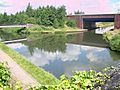
| Tame Valley Junction (Doe Bank Junction) | 52°32′24″N 2°02′07″W / 52.5400°N 2.0354°W | SO976935 | Tame Valley Canal |
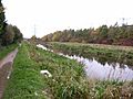
| Gospel Oak Branch Junction | 52°32′57″N 2°02′13″W / 52.5493°N 2.0370°W | SO975945 | |
| Moorcroft Junction | 52°33′15″N 2°02′28″W / 52.5541°N 2.0411°W | SO972951 | Bradley Branch |
| Anson Branch Junction | 52°34′39″N 2°01′20″W / 52.5775°N 2.0221°W | SO986977 | Anson Branch, leading to Bentley Canal |
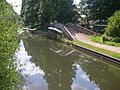
| Walsall Junction | 52°35′05″N 1°59′34″W / 52.5848°N 1.9928°W | SP005986 | Short branch to Walsall centre |
| Birchills Junction | 52°35′55″N 1°59′52″W / 52.5987°N 1.9979°W | SK002000 | Wyrley and Essington Canal |
Images for kids
-
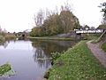
Birchills Junction
-
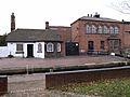
Walsall Locks toll office and Boaters Mission
-
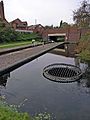
Circular weir at Walsall Lock No 5
-
Walsall Junction - the Town Branch
-
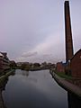
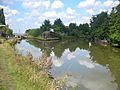
Walsall Canal by Spine Road
-
Gospel Oak Junction (Walsall canal runs left and right)
-
Tame Valley Junction - start of the Tame Valley Canal
-
Ocker Hill Tunnel Branch Junction (now private)
-
Ryders Green Junction - southern terminus


