
Anson Branch facts for kids
Quick facts for kids Anson Branch |
|
|---|---|

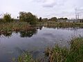
The canal near Bentley Mill Bridge
|
|
| Specifications | |
| Locks | 0 |
| Status | derelict but watered |
| History | |
| Original owner | Birmingham Canal Navigations |
| Date of act | 1768 |
| Date of first use | 1830 |
| Geography | |
| Start point | Bentley Mines |
| End point | Walsall Canal |
| Branch(es) | Bentley Canal (defunct) |
| Branch of | Walsall Canal |
The Anson Branch is a short canal in the West Midlands, England. It stretches for just over one mile. It starts where it meets the Walsall Canal near Forster's bridge. This canal is part of the Birmingham Canal Navigations network.
Today, only some parts of the canal have water. Boats can no longer travel on it. It used to connect to the Bentley Canal, which is also no longer used. The Bentley Canal then linked up with the Wyrley and Essington Canal. The Anson Branch has no locks, which are special water lifts for boats.
Contents
History of the Anson Branch Canal
Building the Canal
The idea for the Anson Branch was approved by a law called the Birmingham Canal Act in 1768. But it took a long time to build! It wasn't finished until 1830. A famous engineer named Thomas Telford planned the route. He thought it would cost about £9,499 to build.
The canal needed to cross the River Tame. This was just north of where it joined the Walsall Canal. So, builders had to create an aqueduct (a bridge for water) and a large embankment (a raised bank). Telford wanted Thomas Townsend to do the work. Mr. Townsend wasn't sure because he thought Telford's cost estimate was too low. But he was convinced, and the building contract was signed in March 1830.
Serving Mines and Factories
The canal was built to help transport goods from the coal mines. It also served a limestone quarry in Bentley. These mines and the quarry belonged to the Earl of Lichfield. From the Walsall Canal, the Anson Branch went mostly straight. It headed northeast for most of its path.
Near the mines, it turned north to reach a special loading area called a wharf. From this wharf, horse-drawn tramways carried coal and other materials. They connected to the Bentley mines and furnaces. By 1832, several large furnaces were also built near the end of the canal. People even thought about building another branch, the Bradford Branch. This would help reach more minerals further north. But only a small part of it was built as a canal. The rest was a narrow-gauge tramway, finished in 1840. The canal company owned and ran this tramway.
Connecting Canals
On February 9, 1840, the Wyrley and Essington Canal joined with the Birmingham Canal Navigations. The new, bigger company wanted to connect their canal systems. The Bentley Canal was one of these new connections. It ran from the Anson Branch to the Wyrley and Essington Canal at Wednesfield. This important link opened in 1843.
New Uses and Decline
By the 1890s, many of the mines had run out of coal. Local industries started to slow down in the early 1900s. But the canal found a new purpose! A power station was built at Birchills. Construction started in 1914. Some parts were working by 1916, and it was fully finished in 1922.
The power station needed a lot of water. So, a pumping station was built next to the canal. It had two large Mather and Platt pumps. These pumps could move 10.6 million gallons (48 Megalitres) of water every day. After the water was used by the power station, it flowed into the Wyrley and Essington Canal. This helped supply water to other parts of the canal system. Because of this, an older pumping station near Birchills locks was shut down.
From 1927, the power station was managed by a different authority. Then, in 1948, it became part of the British Electricity Authority. A second power station was added in 1949.
Abandonment and Legacy
The part of the canal above the Bentley Canal junction was no longer used for boats after 1956. The Bentley Canal and the rest of the Anson Branch were officially closed in 1961. When the M6 motorway was built, it crossed the canal's path. Because the canal still supplied water to the power station, a culvert (a tunnel for water) was built under the motorway. It was big enough for small maintenance boats.
The power station stopped working in 1980. The pumps were turned off. Since then, the canal has slowly fallen into disrepair. Today, the remains of the canal cover about 13.6 acres (5.5 ha). Walsall Council has named this area an important site for nature conservation.
Points of Interest Along the Canal
| Point | Coordinates (Links to map resources) |
OS Grid Ref | Notes |
|---|---|---|---|
| Northern terminus | 52°35′34″N 2°00′24″W / 52.5929°N 2.0067°W | SO995994 | Bentley mines and quarry |
| Bentley Canal Junction | 52°34′52″N 2°01′06″W / 52.5812°N 2.0182°W | SO987981 | |
| Anson Branch Junction | 52°34′39″N 2°01′20″W / 52.5775°N 2.0221°W | SO986977 | Southern terminus at junction with Walsall Canal |
Images for kids
-
The junction with the Walsall Canal, which runs left and right

