
River Tame, West Midlands facts for kids
Quick facts for kids River Tame |
|
|---|---|

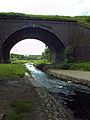
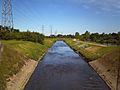
The Tame at Tamworth, which takes its name from the river.
|
|

Sketchmap of the course and catchment of the River Tame, showing locations of some features mentioned in the text
|
|
| Country | England |
| Counties | West Midlands, Warwickshire, Staffordshire |
| Cities | Wolverhampton, Birmingham |
| Towns | Oldbury, West Midlands, Tipton, Wednesbury, Willenhall, Walsall, Tamworth |
| Physical characteristics | |
| Main source | Oldbury Arm Titford, Oldbury 52°29′11″N 2°01′25″W / 52.4863°N 2.0235°W |
| 2nd source | Willenhall Arm Willenhall, Walsall 52°34′32″N 2°05′32″W / 52.5756°N 2.0922°W |
| River mouth | Confluence with the River Trent Alrewas, Staffordshire 52°43′52″N 1°43′02″W / 52.7312°N 1.7173°W |
| Length | 95 km (59 mi) |
| Basin features | |
| Basin size | 1,500 km2 (580 sq mi) |
| Tributaries |
|
| Progression : Tame—Trent—Humber—North Sea | |
The River Tame is a river in the West Midlands of England. It is one of the main rivers that flows into the River Trent. The Tame is about 95 kilometers (59 miles) long. It starts near Oldbury and joins the Trent near Alrewas.
The River Tame is part of the Severn-Trent flyway. This is a special route that migratory birds use to travel across Great Britain.
Contents
What's in a Name? The River Tame's History
The name "Tame" comes from an old Celtic language. Some people think it means "dark." Others believe it means "slow-moving" or "flowing." The exact meaning is not fully known. Many other rivers in England share a similar name. These include the River Thame and the River Thames.
Ancient Settlers: The Tomsæte Tribe
Long ago, a tribe called the Tomsaete lived near the River Tame. Their name means "Tame-dwellers." They were an Anglian tribe. They settled in the Tame valley and around Tamworth. These people later helped form the Kingdom of Mercia.
Where the River Tame Flows
The River Tame has two main starting points. One is near Willenhall, and the other is near Oldbury. These are called the Willenhall arm and the Oldbury arm. Some smaller streams that feed the Tame start even further away. These include streams from Wolverhampton.
Over many years, people have changed the river's path. In cities, parts of the river now flow through underground tunnels called culverts. Other parts are in straight, man-made channels. Both arms of the Tame flow through the Black Country. They meet at Bescot, near Walsall.
The Willenhall Arm: A Northern Start
The northern part of the Tame starts near Bentley, close to Willenhall. Some studies trace it back to Stow Heath, near Bilston. Here, it begins as a marshy area. Old maps show its source even further back, at a former coal mine.
This stream flows mostly northeast. It goes through Stowlawn and the southern edge of Willenhall. It picks up more water from the Waddens Brook. The river becomes clearer at Watery Lane and Bentley. It then flows south, often alongside or under the M6 motorway. Finally, it reaches Bescot.
- The Willenhall or Wolverhampton arm
-
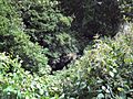
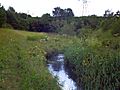
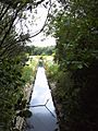
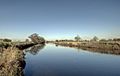
The Willenhall Arm, close to the source, among residential areas near Shepwell Green. The river is disclosed by the tiny area of reflection in the centre of the photograph - a small stream between overgrown banks, and almost inaccessible, although it forms the town's boundary.
-
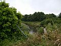
The Willenhall Arm at Bentley Green, Walsall, just after passing under the Black Country Route. Despite the appearance at this point it here enters an area of heavy industry.
-
The Willenhall branch south of the Anson Branch Canal, near the Bentley Mill entertainment and retail area.
-
The Willenhall Arm passes a large retail development at Axletree Way, Wednesbury, formerly a heavy industrial site. The Tame is completely screened from the road and pedestrian ways at this point, though only a few metres away.
-
Confluence of the Oldbury Arm (left) and the Willenhall Arm (right), close to Bescot Stadium railway station, under the M6 Motorway.


The Oldbury Arm: A Southern Journey
The southern part of the Tame starts near Oldbury town center. It can be traced back to an industrial area at Titford. This is just west of the M5 motorway. It flows through Langley and around Oldbury. It becomes visible south of Sandwell and Dudley railway station.
The Oldbury arm then flows northwest. It passes Brades Village and goes into Tipton. Here, it flows through Sheepwash Urban Park. It continues to Great Bridge. Leaving Tipton, it zig-zags through Wednesbury. It meets the Willenhall arm at Bescot.
- The Oldbury arm
-
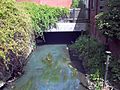
The Oldbury Arm of the Tame, close to where it enters Sheepwash Urban Park, via a culvert under the West Coast Main Line.
-
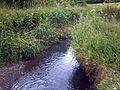
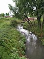
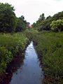
Oldbury Arm of the Tame close to its entrance to the Sheepwash Urban Park, between Great Bridge, Tipton, and West Bromwich. At this point it is still only 1–2 metres wide if not in flood.
-
Largest of the lakes in Sheepwash Urban Park. This is a storm water retention basin, fed by the Oldbury Arm, providing an important urban habitat.
-
Canalised channel of the Tame. Sluices feeding the Sheepwash lakes are visible on both sides.
-
The Oldbury Arm at Tame Bridge, just south of Great Bridge.
-
Steadily widening, the Oldbury Arm approaches Great Bridge.
-
The Oldbury Arm near Hill Top, Wednesbury. This section is heavily industrial, with very little public access, and the river often passing under warehouses and factories.


The Main River's Path
After the two arms meet, the Tame flows through Sandwell Valley. It then enters northern Birmingham. It passes through Hamstead and Perry Hall Park. At Perry Barr, it goes under the historic Perry Bridge from 1711. It continues through Witton.
The Tame flows under the Gravelly Hill Interchange. Here, it is joined by the River Rea. It also passes under the Bromford Viaduct. The river then goes to Washwood Heath.
- Confluence to Sandwell Valley
-
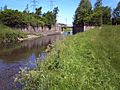
Aqueduct carrying the Tame Valley Canal over the River Tame at Ray Hall.
-
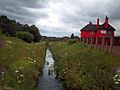
The Tame at Ray Hall sewage works, from the Tame Valley Canal aqueduct, with the Charlemont area of West Bromwich on the right.
-
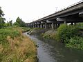
The Tame flowing under the M5 motorway interchange with the M6 motorway northbound, after which it enters Sandwell Valley.
-
Steep, eroded banks of the Tame in upper part of Sandwell Valley.
-
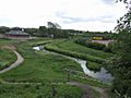
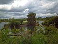
A canalised section of the Tame in Sandwell Valley, showing Forge Mill Lake to the right, separated from the river by a steep embankment.
-
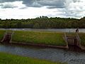
Sluices controlling the flow of water into Forge Mill Lake, a storm water retention basin.
-
Bridge over the canalised section, linking the lake to Forge Mill Farm
-
Bed and banks of the river, which is usually shallow and fast-flowing at this point.
-
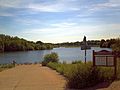
Forge Mill Lake. The RSPB reserve's bird hide is visible across the lake, in the centre of the photograph.


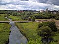
The river then goes north of Castle Bromwich. It leaves Birmingham at Park Hall Nature Reserve. It passes Water Orton in Warwickshire. At Hams Hall, it is joined by the River Blythe. It then turns north and flows into the water purification lakes at Lea Marston. These lakes are now part of Kingsbury Water Park.
The Tame then enters Staffordshire. It flows through Middleton Lakes RSPB reserve. It passes under Watling Street and an aqueduct carrying the Coventry Canal. It continues north to Tamworth. This town is named after the river. In Tamworth, the River Anker joins the Tame. The Tame flows past Hopwas and Elford. It reaches the National Memorial Arboretum. Here, it forms a border with the Croxall Lakes Nature Reserve.
Finally, the Tame flows under a railway at Wichnor Viaduct. It then meets the River Trent near Alrewas. The water from the Tame eventually flows into the North Sea. This happens via the Humber Estuary. When the Tame and Trent meet, the Tame actually carries more water. However, the Trent is longer at that point. So, the combined river keeps the name "Trent."
- The Lower Tame in Staffordshire
-

The Tame at Tamworth, with Lady Bridge in the foreground and Tamworth Castle behind.
-
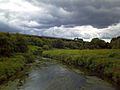
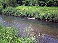
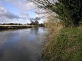
The Tame east of Hopwas
-
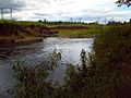
the Tame at Elford, north of Tamworth.
-
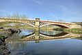
The Tame passing under Chetwynd Bridge near Alrewas, designed by Joseph Potter in 1828.
-
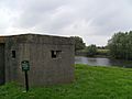
Pillbox on the west bank of the Tame, one of many defences constructed along the Midlands rivers during World War II.
-
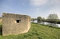
Pillbox on the west bank of the River Tame
-
The Tame at the edge of the National Memorial Arboretum, with Croxall Lakes to the left.
-

Confluence of the Tame (right) with the River Trent (left), at the northern edge of the National Memorial Arboretum.


The Tame's Catchment Area
The area that drains into the Tame is called its catchment area. This area covers almost 1500 square kilometers (579 square miles). About 1.7 million people live in this area. Around 42% of the Tame's basin is covered by cities and towns. This makes it the most urbanized river basin in the United Kingdom.
Long ago, industries in Birmingham and the Black Country caused a lot of pollution. To clean the water, the Tame flows through special purification lakes. These are located below Lea Marston in Warwickshire. This system is unique in the UK. A large part of these lakes is now Kingsbury Water Park. Thanks to clean-up efforts, wildfowl like ducks and swans now live on the river. Sandwell Valley has also become an important home for urban wildlife.
The River Tame is not used for boats or ships.
Cleaning Up the River Tame
The River Tame used to be one of the dirtiest rivers in Britain. But now, it is much cleaner. This is because of new laws and the use of the purification lakes at Lea Marston.
Dealing with Flooding

The River Tame has had big flooding problems. This is mainly because many cities and towns are in its upper areas. Rain runs off roofs and paved surfaces very quickly. This makes the river levels rise fast. More houses and buildings have made this problem worse. Also, groundwater levels have risen in the upper areas. Old industries used a lot of water from the river. Now, less water is taken, so the groundwater is higher.
The village of Hopwas often floods when there is heavy rain. The name Hopwas even means "watery nook of land" in Anglo-Saxon. This shows that flooding has been a problem there for a long time.
How Flooding is Prevented
In the 1980s, work was done to prevent floods in Sandwell Valley. Forge Mill Lake was made bigger. It now holds extra stormwater. The river was also dug deeper. The gravel from the river was used to build an island in the lake. This island became part of a nature reserve. Around the same time, a similar system was built at Sheepwash Urban Park. It uses old brick pits to hold stormwater.
In 2005, the river's path in Perry Hall Park was changed. This was done to slow the water flow. It also helped prevent floods and create better habitats for wildlife. This project was called SMURF.
However, in June 2007, after heavy rain, the river still flooded. It burst its banks in Witton and at Kingsbury Water Park.
In 2009, the Environment Agency planned more flood prevention work. They spent £380,000 on improvements. This included dredging the river and removing obstacles. They removed 1000 tonnes of gravel near Chester Road Bridge. This gravel was moved downstream to help fish lay eggs. Silt and debris were also removed from the Gravelly Hill section. Five small dams were removed from the Oldbury Arm. This helps fish move more easily. This work continued into 2011, especially around Water Orton.
Places Along the Tame
| Point | Coordinates (links to map & photo sources) |
|---|---|
| Sheepwash Urban Park | 52°31′22″N 2°02′22″W / 52.5227°N 2.0395°W |
| Confluence of Oldbury & Wednesbury branches | 52°33′50″N 1°59′31″W / 52.56378°N 1.992°W |
| Tame Valley Canal | 52°33′05″N 1°57′58″W / 52.5513°N 1.9661°W |
| Forge Mill Lake inlet | 52°31′55″N 1°57′29″W / 52.531906°N 1.957956°W |
| Forge Mill Lake outlet, RSPB Sandwell Valley | 52°31′52″N 1°57′00″W / 52.531°N 1.950°W |
| SMURF works, Perry Hall Park | 52°31′31″N 1°55′06″W / 52.5253°N 1.9184°W |
| Confluence with Holbrook | 52°31′32″N 1°53′53″W / 52.525527°N 1.898008°W |
| Zig Zag bridge (1711) | 52°31′31″N 1°53′50″W / 52.52534°N 1.89711°W |
| Aldridge Road bridge (1932, art deco) | 52°31′31″N 1°53′49″W / 52.52530°N 1.89681°W |
| Confluence of Hockley Brook | 52°30′29″N 1°51′37″W / 52.508184°N 1.860258°W |
| Confluence of River Rea | 52°30′15″N 1°50′38″W / 52.504101°N 1.843814°W |
| Confluence of Plants Brook | 52°30′53″N 1°46′40″W / 52.5146°N 1.7777°W |
| Confluence of Churchill Brook | 52°31′17″N 1°45′31″W / 52.5213533°N 1.7584736°W |
| Confluence of River Blythe | 52°31′19″N 1°41′20″W / 52.52189°N 1.68879°W |
| Ladywalk Reserve (West Midland Bird Club) | 52°31′23″N 1°40′52″W / 52.5231°N 1.6812°W |
| Kingsbury Water Park | 52°33′43″N 1°41′45″W / 52.562°N 1.6958°W |
| RSPB Middleton Lakes | 52°34′39″N 1°42′36″W / 52.5774°N 1.710090°W |
| Lady Bridge, Tamworth Confluence of River Anker |
52°37′55″N 1°41′55″W / 52.6319°N 1.6986°W |
| Croxall Lakes (Staffordshire Wildlife Trust) | 52°43′39″N 1°43′13″W / 52.727461°N 1.7204°W |
| National Memorial Arboretum | 52°43′43″N 1°43′35″W / 52.7287°N 1.7263°W |
| Confluence with River Trent | 52°43′52″N 1°43′02″W / 52.7312°N 1.7173°W |
Rivers That Join the Tame
Many smaller rivers and streams flow into the River Tame. These are called tributaries. Here are some of them:
- River Anker
- Bourne Brook (joins at Fazeley)
- River Bourne (joins near Whitacre Junction)
- River Blythe
- Crane Brook
- Norton Brook
- Footherley Brook
- Little Hay Brook
- Churchill Brook
- Plants Brook
- Hockley Brook
- River Rea
- Holbrook
- From the Willenhall or Wolverhampton Arm:
- Ford Brook
- Sneyd Brook
- Darlaston Brook
- Waddens Brook
- From the Oldbury Arm:
- Many small streams that are part of the Oldbury Arm itself.
