River Anker facts for kids
Quick facts for kids River Anker |
|
|---|---|

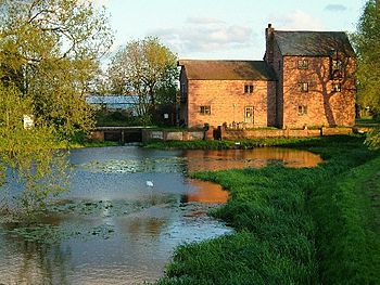
Alders Mill on the River Anker near Pinwall
|
|

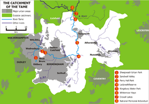
Course and catchment of the River Anker, shown on the eastern side of the Tame catchment
|
|
| Country | England |
| Counties | Leicestershire, Warwickshire, Staffordshire |
| Towns | Nuneaton, Tamworth |
| Physical characteristics | |
| Main source | Wolvey, Warwickshire 52°28′33″N 1°20′50″W / 52.47590°N 1.34728°W |
| River mouth | River Tame Tamworth, Staffordshire 52°37′53″N 1°41′52″W / 52.6315°N 1.6977°W |
| Length | 50 km (31 mi) |
| Basin features | |
| Tributaries |
|
The River Anker is a river in England. It flows right through the middle of Nuneaton. The Anker is a big tributary (meaning a smaller river that flows into a larger one) of the River Tame. It joins the River Tame in a town called Tamworth.
The name "Anker" comes from an old British word. This word described a "winding river," which means a river that twists and turns a lot. From where it starts to where it meets the River Tame, the River Anker is about 50 kilometres (31 mi) long.
Contents
Where Does the River Anker Flow?
The River Anker begins its journey near a village called Wolvey. It then flows towards the north-west. It passes between Bramcote and Burton Hastings. At Stretton Baskerville, it becomes a "main river." This means it's an important river for managing water. Here, it also forms the border between three areas: Rugby, Nuneaton, and Bedworth.
The Anker's Path Through Towns
As the river reaches the edge of Nuneaton, another small stream called Sketchley Brook joins it. The Anker then flows past the Liberty Way sports stadium. In Nuneaton, the river actually splits into two parts. One part is a special channel built to help with floods. The other part, the main river, goes through the town centre.
The two parts of the river join up again beyond Nuneaton, near Weddington. The river then keeps flowing north-west. It passes the villages of Caldecote and Mancetter. At Mancetter, an old Roman road called Watling Street crosses over it. The river also flows past Witherley.
Meeting Other Rivers and Nature Reserves
Next, the River Anker reaches Atherstone. Here, another river, the River Sence, flows into it. After this, the Anker goes through Grendon and then Polesworth. It then flows under the M42 motorway.
Beyond the motorway, the river passes through a special place called Alvecote Pools and meadows. This area is a 128 ha (320 acres) Site of Special Scientific Interest (SSSI). This means it's a very important place for nature and wildlife. It's also a nature reserve, which protects animals and plants. The Anker continues past Amington Hall. Finally, it turns south-west and flows through Tamworth. It joins the River Tame near Tamworth Castle.
Fish in the River Anker
The River Anker is a popular spot for people who like to fish. It's known for having some large fish. You might find big pike and chub here. There are also reports of barbel, with some fish weighing over 15 pounds!
How Much Water Does the River Anker Carry?
Scientists have been measuring how much water flows in the River Anker since 1966. They do this at a special measuring station in Polesworth. The area that collects water for the river (called the catchment) up to this station is about 386 square kilometres (149 sq mi). On average, about 3.2 cubic metres per second (110 cu ft/s) of water flows past this point.
The highest water level ever recorded at the Polesworth station was on November 25, 2012. The river reached a height of 2.57 metres (8 ft 5 in). At that time, a huge 128 cubic metres per second (4,500 cu ft/s) of water was flowing! The area around the river gets about 653 millimetres (25.7 in) of rain each year. The highest point in the river's catchment area is 275 metres (902 ft) high. This is near Bardon Hill.
Why Does the River Anker Flood?
The River Anker has caused floods in Nuneaton town centre several times. One big flood happened in 1968. Because of these floods, a special channel was built in 1976. This "flood relief channel" is about 600-metre-long (2,000 ft). It helps to carry away extra water when the river gets too full. This channel is located in Weddington.
In July 2007, the river flooded the Liberty Way sports pitch. This meant that the local sports teams, Nuneaton Town and Nuneaton RFC, had to cancel their games. They had to wait for the river water to drain away from the pitch.
See also
 In Spanish: Río Anker para niños
 | Tommie Smith |
 | Simone Manuel |
 | Shani Davis |
 | Simone Biles |
 | Alice Coachman |

