
River Blythe facts for kids
Quick facts for kids River Blythe |
|
|---|---|

The river near Hampton-in-Arden
|
|
| Country | England |
| Physical characteristics | |
| Main source | Earlswood Lakes, Warwickshire 52°21′58″N 1°50′00″W / 52.366184°N 1.833267°W |
| River mouth | Confluence with the Tame at Ladywalk 52°28′0″N 1°40′45″W / 52.46667°N 1.67917°W |
| Basin features | |
| Progression | Tame—Trent—Humber—North Sea |
The River Blythe is a river in the English Midlands. It starts in central Warwickshire, flows through Solihull, and ends near Coleshill. The Blythe flows through an area called the Meriden Gap. It gets water from the River Cole. The River Blythe then joins the River Tame near the Ladywalk reserve. The Tame then flows into the River Trent, and finally, its waters reach the North Sea through the Humber Estuary.
Contents
Where the River Blythe Flows

The River Blythe begins near Earlswood Lakes. Its main starting point is a stream called Spring Brook. From there, the river winds north-east. It flows past Cheswick Green and then reaches Solihull.
In Solihull, the river goes through a local wildlife area. This is called Malvern and Brueton Park and Nature Reserve. Here, the river briefly splits to form Brueton Park Lake. After the park, the river flows east. It passes old country houses like Old Berry Hall.
River's Journey to the Tame
The river then turns sharply south towards Barston. It makes a big loop around this village. At Temple Balsall, a stream called Cuttle Brook adds water to the Blythe. The river then turns north again, passing Barston once more.
Further north, past Hampton in Arden, another stream called Shadow Brook joins the river. The Blythe continues north, flowing east of Coleshill. Just a short distance before it joins the River Tame, the River Cole flows into the Blythe. The Blythe finally meets the River Tame at Ladywalk Nature Reserve.
A Special River Environment

The River Blythe is a very special place. Experts call it "a particularly fine example of a lowland river on clay." Because of its unique features, a long part of the river is protected. It is known as a Site of Special Scientific Interest (SSSI). This protection started in 1989. The SSSI covers about 24 miles (39 km) of the river. It stretches from near where the river starts to where it joins the River Tame.
River Features and Habitats
The Blythe has many natural features. These include shallow, fast-flowing areas called riffles. It also has deeper, slower areas called pools. There are small cliffs along its banks and winding bends called meanders. The riverbed itself is varied. In the lower parts, it has fine silt and clay. In the upper and middle parts, you can find sand and gravel. This mix of features makes the river very diverse. It is a rare and important example of such a river in lowland Britain.
Plants and Animals of the Blythe

The River Blythe is home to many different kinds of plants. It is one of the richest rivers in lowland England for plant life. Some parts of the river have as many plant species as the very best chalk streams. Along the river, you can also find damp meadows. These meadows get water from floods and depend on the river to stay wet.
River Invertebrates and Fish
Besides the rich plant life, the river supports many small animals without backbones. These are called invertebrates. You can find many types of molluscs (like snails). There are also oligochaetes (a type of worm) and caddisflies (insects that live in water as larvae).
The river is also a popular spot for fishing. People enjoy angling along much of its length. However, in dry weather, some parts of the river can become quite shallow. Fish you might catch include perch, chub, and dace. Sometimes, carp are caught in the summer. Other fish found here are tench, bream, and rudd. More recently, a small number of barbel have also been caught. The River Blythe is known as one of the cleanest rivers in England.
Images for kids
-
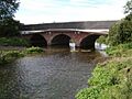
The river near Hampton-in-Arden
-
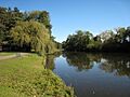
Brueton Park Lake, formed by the damming of the River Blythe at Solihull
-
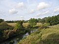
Blythe Valley, looking north along the River Blythe near Eastcote
-
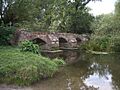
The old Packhorse Bridge, south of Hampton-in-Arden, crossing the River Blythe
