
Humber facts for kids
Quick facts for kids Humber |
|
|---|---|

Humber Bridge viewed from the south-east
|
|

Mouth of the Humber
|
|
| Country | England |
| Counties | East Riding of Yorkshire, Lincolnshire |
| Cities | Kingston upon Hull |
| Towns | Brough, Grimsby, Immingham, Barton upon Humber, Cleethorpes |
| Physical characteristics | |
| Main source | Trent Falls 53°42′03″N 0°41′28″W / 53.7008°N 0.6911°W |
| River mouth | North Sea, between Spurn Head 53°32′34″N 0°05′32″E / 53.5427°N 0.0923°E |
| Length | 38.5 mi (62.0 km) |
| Basin features | |
| Basin size | 24,240 km2 (9,360 sq mi) |
| Tributaries |
|
| Designation | |
| Official name: Humber Estuary | |
| Designated: | 28 July 1994 |
| Reference #: | 663 |


The Humber is a very large tidal estuary on the east coast of Northern England. An estuary is where a river meets the sea, and the water is a mix of fresh and salt water. The Humber forms where two rivers, the Ouse and the Trent, meet at a place called Trent Falls in Faxfleet.
From Trent Falls, the Humber flows towards the North Sea. It creates a natural border between the East Riding of Yorkshire on its north side and North Lincolnshire on its south side. Even though it's an estuary, many maps still call it the River Humber.
As the Humber flows, it passes several important places. On the north side, the Market Weighton Canal joins it. On the south side, the River Ancholme flows in. It then goes under the famous Humber Bridge between North Ferriby and South Ferriby. Further along, the River Hull joins the Humber near Kingston upon Hull. Finally, the Humber reaches the North Sea between Cleethorpes and the long, thin piece of land called Spurn Head.
Many important ports are located on the Humber. These include the Port of Hull, the Port of Grimsby, and the Port of Immingham. Smaller ports are found at New Holland and North Killingholme Haven. The Humber is deep enough for even the largest ships to sail on.
Contents
History of the Humber Estuary
The Humber has a long and interesting history. During the last Ice Age, it was actually a much longer freshwater river. It stretched across what is now the dry bed of the North Sea.
Ancient Stories and Boundaries
The Humber often appears in old British stories from the Middle Ages. In ancient Welsh tales, it is named as one of Britain's three main rivers. It was also an important boundary in the Brut y Brenhinedd, separating the southern kingdom from northern lands. A 12th-century book says the Humber was named after "Humber the Hun". This invader supposedly drowned there during a battle long ago.
The Humber continued to be a key boundary during the Anglo-Saxon period. It separated the northern kingdom of Northumbria from the southern kingdoms. The name Northumbria actually means "the people north of the Humber".
An ancient Greek map from the 2nd century AD shows the Humber as the "Abus river". It flows into the German Ocean, which is now called the North Sea. This map also shows the ancient tribes living near the Humber. The Coritani lived south of it, and the Parisi lived to the north.
Modern History and Crossings
In the famous 1719 novel Robinson Crusoe, the main character starts his journey from England on a ship leaving the Humber.
A sad event happened on August 23, 1921. The British airship R38 crashed into the estuary near Hull. This accident tragically killed 44 of the 49 people on board.
From 1974 to 1996, the areas around the Humber were part of a county called Humberside. Since 1996, the Humber forms the border between the East Riding of Yorkshire to the north and North Lincolnshire and North East Lincolnshire to the south.
The Humber Bridge
The only modern way to cross the Humber estuary is the Humber Bridge. When it was built in 1981, it was the longest single-span suspension bridge in the world. Today, it is the twelfth longest.
Before the bridge, people crossed the Humber using paddle steamers. These ferries ran from Hull to New Holland. The ferry service started in 1841 and continued until the bridge opened in 1981. The bridge's path is similar to an old ferry route that existed way back in 1281.
Humber Defences
Special forts were built at the mouth of the Humber estuary for the First World War. These were called the Humber Forts. Their construction began in 1915 and finished in 1919. They were also used during the Second World War but were closed for military use in 1956.
Another fort, Fort Paull, is located further upstream. This fort was built during the time of Napoleon.
Crossing the Humber on Foot
In August 2005, a man named Graham Boanas from Hull managed to wade across the Humber. He is thought to be the first person to do this since ancient Roman times! He did it to raise money for a medical charity. He started on the north bank at Brough and reached the south bank at Whitton four hours later. He is very tall, at 6 feet 9 inches, and he crossed during a very low tide. He even repeated this feat on the TV show Top Gear.
Swimming the Humber
On August 26, 1911, Alice Maud Boyall became the first woman to swim across the Humber. She was 19 years old and a swimming champion from Yorkshire. She swam from Hull to New Holland Pier in 50 minutes.
Since 2011, there has been an organized charity swim called the 'Warners Health Humber Charity Business Swim'. Swimmers cross the estuary under the Humber Bridge to raise money for Humber Rescue.
In 2019, Richard Royal became the first person to swim across the estuary and back again. He started and finished at Hessle, with Barton on the south bank as his halfway point. He holds the record for the fastest one-way swim (35 minutes 11 seconds) and the fastest two-way swim (1 hour, 13 minutes, 46 seconds). He also raised over £900 for Humber Rescue.
What Does "Humber" Mean?
Many river names in Europe come from Celtic words. The name Humber might come from a Celtic word meaning "moisture" or "good, well".
Another idea is that it comes from a word meaning "to boil" or "to soak." This might be related to the name of the nearby River Hull.
In some old Latin writings, the estuary is called Abus. This could be a Latin version of the Celtic word Aber, which means "river mouth" or "estuary" in Welsh. Both Abus and Aber might come from an even older word for water or river.
Wildlife and Nature
The Humber is home to many different kinds of fish. Fish like Salmon, sole, cod, eel, flounder, and plaice live there. Many fish also travel through the Humber when they return from the sea to lay their eggs in rivers further inland.
The Humber is also a very important place for birds. Many birds spend the winter there, and it's a good place for birds like bitterns, marsh harriers, little terns, and avocets to breed. It is part of the Severn-Trent flyway, which is a route that migratory birds use to cross Great Britain.
In 2019, the Yorkshire Wildlife Trust and the University of Hull brought river oysters back to the Humber. Oysters had been missing from the estuary for sixty years!
See also
 In Spanish: Humber para niños
- Industry of the South Humber Bank
- North Wall, Lincolnshire
- Humber, the name of one of the sea areas of the British Shipping Forecast.
- Lagoon Hull
- River Hull
- River Trent
- River Ouse, Yorkshire
- River Don, South Yorkshire
- Aire and Calder Navigation
- River Ancholme
- Market Weighton Canal
Images for kids
-
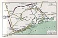
Historical railway map of Hull showing the ferry route and the layout of docks
-
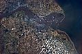
The Humber from the International Space Station


