
River Hull facts for kids
Quick facts for kids River Hull |
|
|---|---|

The tidal barrier and the Millennium Bridge at the mouth of the river
|
|

Course of the river within the East Riding of Yorkshire
|
|
| Country | England |
| County | East Riding of Yorkshire |
| Physical characteristics | |
| Main source | Driffield 65 ft (20 m) |
| River mouth | Humber Estuary Kingston upon Hull 0 ft (0 m) 53°44′20.17″N 0°19′52.3″W / 53.7389361°N 0.331194°W |
The River Hull is a river in Northern England. It flows through the East Riding of Yorkshire. The river starts from springs near Driffield. It then flows into the Humber Estuary at Kingston upon Hull. For a long time, people had to pay tolls to use the river. Later, it became free to use for boats. However, parts of the river near Driffield and within Hull still have tolls.
Most of the River Hull flows through very flat land. This land is often at or below sea level. Because of this, flooding has always been a big problem. To stop floods, special drainage systems were built. The Holderness Drainage scheme was built on the east side. The Beverley and Barmston Drain was built on the west side. Since 1980, a large barrier protects the river's mouth. This barrier stops high tides from the sea from causing floods upstream.
Many bridges cross the River Hull. Most of these bridges can move to let ships pass. There are different types of movable bridges. These include swing bridges, bascule bridges, and Scherzer lift bridges. Some old bridges were powered by a special water system. This system was one of the first public power systems in the world.
Contents
- What's in a Name? The River Hull's Origin
- The River Hull's Journey: From Springs to Sea
- A River Through Time: The History of the River Hull
- River Traffic: Boats and Goods on the Hull
- Keeping the Land Dry: Drainage Systems
- Crossing the River Hull: Bridges and Tunnels
- River Health: Water Quality of the River Hull
- Images for kids
- See also
What's in a Name? The River Hull's Origin
The name Hull likely comes from an old British language. It might be linked to a word meaning "boil" or "soak." This suggests how the river might have looked or behaved.
The River Hull's Journey: From Springs to Sea
The River Hull begins in the Yorkshire Wolds. It starts from several springs west of Driffield. These springs are near an old village called Elmswell. Small streams like Elmswell Beck and Little Driffield Beck join together. They form the Driffield Beck, which flows around Driffield.
After Driffield, it becomes the River Hull or West Beck. It flows east, then turns south towards Corps Landing. A special waterway called the Driffield Navigation runs next to the river. This navigation helps boats travel.

From Corps Landing to its mouth, the river is navigable. This means boats can travel on it. Near Emmotland, the Frodingham Beck joins the river. This beck also leads to a canal that goes to Driffield. This canal is a big part of the Driffield Navigation.
Further south, the Struncheon Hill lock marks the end of the Navigation. Below this lock, the river is affected by tides from the sea. The water level can change a lot with the tides. The land around the river is very flat. High banks have been built to stop the river from overflowing.
As the river gets closer to Hull, many bridges cross it. Most of these bridges open to let ships pass. The river divides the city's industrial areas. Sometimes, these opening bridges can cause traffic jams. The River Hull finally meets the Humber Estuary in the middle of Kingston upon Hull. A large tidal barrier is at its mouth. This barrier stops huge tidal waves from flooding the city and the flat land nearby.
A River Through Time: The History of the River Hull
The River Hull has been important for both travel and draining land. These two uses sometimes caused problems. Boats needed higher water levels, but drainage needed lower levels. In 1213, the Archbishops of York claimed control of the river. They said they had the right to use a wide channel for boats.
Fish traps in the river made it hard for boats to pass. In 1296, the Archbishop arranged for these traps to be removed. This helped set up a dock at Grovehill for the town of Beverley. By 1321, they started charging tolls to use the river. But merchants in Hull were unhappy. Eventually, the river became free to use without tolls. Only a small part near the mouth, controlled by the Port of Hull, still had tolls.
The river's outlet to the Humber has changed over time. Originally, it flowed out at Limekiln Creek. Another channel, Sayers Creek, was later made wider. At one point, both outlets existed. Limekiln Creek then became just a small drain.

In medieval times, the lower river was surrounded by salty marshes. People started draining these marshes early on. Further upstream, monks from Meaux Abbey dug channels in the 12th and 13th centuries. These were mainly for boats but also helped with drainage.
In the 1700s, people wanted to improve the river for larger boats. Engineers like John Smeaton and John Grundy, Jr. suggested building canals. A new canal route was opened in 1770. This new route was much shorter than the winding river. The river above Aike then became part of the Driffield Navigation, and tolls were charged again. Also, the first part of the Holderness Drain was built. This helped drain land to the east of the river. The river banks were also raised to prevent flooding.
Improving the river continued to be a challenge. The Driffield Navigation wanted to replace the old stone Hull Bridge near Beverley. They wanted a swing bridge to make it easier for boats. But the town of Beverley owned the bridge and didn't want it changed. It was a main route to Holderness. After many disagreements, an agreement was reached in 1801. A new Act of Parliament allowed for towpaths and a new cut to shorten the river. The bridge was rebuilt for £500.

Passing through Hull was difficult because of all the ships. In 1794, merchants suggested building docks in Hull with a separate entrance. This would stop river traffic from being blocked. The Driffield Navigation tried to ensure free passage for boats. They also wanted to remove tolls for boats not using the docks.
In 1980, the Environment Agency built a tidal barrier at the river's mouth. This huge steel gate weighs 202 tonnes. It can be lowered to seal the river from the Humber. This stops tidal surges from flooding the city and surrounding areas. The barrier protects about 17,000 properties. In 2009, it got a £10 million upgrade to keep it working for another 30 years. The barrier was given Grade II listed status in 2017. This means it is a historically important building.
River Traffic: Boats and Goods on the Hull
Since the lower river was free, we don't have exact numbers for all traffic. But we can learn about it from nearby waterways that charged tolls. In 1730, boats on Beverley Beck mainly carried coal, bricks, and wool. They also carried grains like wheat and barley. Toll money more than doubled between 1732 and 1748.
Trade on the Driffield Navigation also grew. In 1789, a company arranged to pay a fixed amount for coal and carpets. This shows how busy the river was. Tolls on Beverley Beck kept going up. In 1838, over 31,000 tons of goods were carried.
In 1817, a steam boat service started between Driffield and Hull. It made three trips a week. By 1823, three boats were regularly trading between the towns. In 1832, a lot of coal, wheat, oats, and barley were carried.
Between 1848 and 1905, traffic on Beverley Beck more than tripled. Coal and other minerals made up a quarter of the traffic. Goods like fertilizer and scrap metal were also carried. Commercial traffic continued into the 1970s. Traffic on the Driffield Navigation was steady until 1905. It then declined, and commercial traffic stopped in 1944. The Leven Canal also closed in 1935 due to competition from roads.
Keeping the Land Dry: Drainage Systems

Flooding was a big problem for the land next to the river. To solve this, special drains were built on both sides. The Holderness Drainage scheme protected land to the north-east of Hull. Engineers John Grundy and John Smeaton worked on the plans. An Act of Parliament allowed the work to start in 1764. The project included 17 miles of barrier bank along the east side of the river. It was finished in 1772 and cost £24,000.
Even with the Holderness scheme, there were still problems near Leven and Weel. William Jessop suggested separating the water from the higher lands from the local drainage. This second phase of the scheme was completed in 1805. It cost £16,000.
In 1796, Robert Chapman suggested solutions for flooding on the west side. This led to the Beverley and Barmston Drainage Act in 1798. Chapman was the engineer for this project. It cost £115,000 and protected 12,600 acres of land. The project included 23 miles of drainage cuts and 20 miles of embankments along the river. It was finished in 1810.
Crossing the River Hull: Bridges and Tunnels
Many bridges cross the River Hull. They are important for connecting different parts of the area. Most of the bridges in Hull can open to let boats pass. This is because the river is still used by some ships.
Here are some of the bridges, moving from north to south:
| Bridge | Date built | Notes |
|---|---|---|
| New Hull Bridge, Beverley | 1974 | A fixed concrete bridge for the A1035 bypass road. |
| Hull Bridge, Beverley | 1976 | A fixed footbridge. It replaced an older steel bridge. |
| Grovehill Bridge, Beverley | 1953 | A lift bridge. It replaced an old ferry crossing. |
| Ennerdale Link Bridges | 1997 | Twin bascule bridges. These were built after a tunnel project failed. |
| Sutton Road Bridge | 1939 | A Scherzer type rolling lift bridge. It has a cool Art Deco style. |
| Stoneferry Bridge | 1988–91 | Twin bascule bridges. They replaced an older swing bridge. |
| Hull Bridge | 1885 | A steel swing bridge. It was built for the Hull and Barnsley Railway. It's still used by freight trains. |
| Wilmington Swing Bridge | 1907 | An old railway swing bridge. It's now used by walkers and cyclists. |
| Sculcoates Bridge | 1874 | This is the oldest river bridge in the city. It connects Wilmington and Sculcoates. |
| Scott Street Bridge defunct |
1901 | A double bascule bridge. It was permanently raised in 1994 because it was too weak. It was removed in 2020. |
| North Bridge | 1928–32 | There has been a bridge here since 1541. This one is a Scherzer rolling lift bridge. |
| Drypool Bridge | 1961 | A Scherzer rolling lift bridge. It replaced an older swing bridge. |
| Scale Lane Footbridge | 2011–13 | A pedestrian swing bridge. It's an award-winning design. |
| Myton Swing Bridge | 1981 | A large steel swing bridge on the A63 road. |
| Millennium Bridge | 2001 | A pedestrian swing bridge. It gives access to The Deep. |

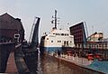
The current Drypool Bridge was built in Hull. It replaced an older, narrower bridge from 1888. The new bridge opened in 1961.
The Scott Street Bridge became very old and weak. In 1994, its moving parts were raised and it has stayed open ever since. It was too expensive to fix. This bridge was once powered by a special high-pressure water system. This system, started in 1872, made Hull the first city in the world to have a public power distribution system.

Plans for a road called the Ennerdale Link included a tunnel under the river. Work started in 1991. But a large hole appeared in the river bed, and the site flooded. The tunnel project was stopped in 1993. Instead, twin lift bridges were built and opened in 1997. The project ended up costing £30 million.
A tunnel was successfully built under the river in 2001. This 6.2-mile long sewer carries waste from the city to a treatment plant. It was dug using two special machines.
Before 1897, there was a ferry at Grovehill. A shipyard owner built a special ferry bridge for his workers. It could be raised or lowered to match the tide. When a boat needed to pass, the bridge would swing open. The local council took over the bridge before World War II. It was replaced by a new lift bridge in 1953.
The Hull Bridge upstream of Beverley was replaced by a steel rolling bridge in 1913. After a new bypass bridge was built, it became a footbridge in 1976. At the other end of the river, the Millennium Bridge opened in 2001. It replaced an old ferry and a swing bridge from 1865.
River Health: Water Quality of the River Hull
The Environment Agency checks the water quality of rivers in England. They give each river a score for its overall health. This score can be high, good, moderate, poor, or bad. They look at things like bugs, plants, and fish in the water. They also check for chemicals.
Here's how the River Hull system's water quality was in 2016:
| Section | Ecological Status | Chemical Status | Overall Status |
|---|---|---|---|
| Driffield Navigation | Good | Good | Good |
| Lowthorpe/Kelk/Foston Bks from Source to Frodingham Beck | Poor | Good | Poor |
| Old Howe/Frodingham Beck to R Hull | Moderate | Good | Moderate |
| Hull from West Beck to Arram Beck | Moderate | Good | Moderate |
| Ella Dyke | Moderate | Good | Moderate |
| High Hunsley to Woodmansey Area | Good | Good | Good |
| Hull from Arram Beck to Humber | Moderate | Good | Moderate |
The water quality is sometimes not "good" because of things like sewage being released into the river. Also, the river channel has been changed a lot by humans.
Images for kids
-
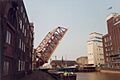
Drypool Bridge, raised to allow a freighter to pass
-
Scott Street Bridge 1990
See also
 In Spanish: Río Hull para niños
