
East Riding of Yorkshire facts for kids
Quick facts for kids
East Riding of Yorkshire
|
|||||||||||||||||||||||||||||||||||||||||||||||||||||||
|---|---|---|---|---|---|---|---|---|---|---|---|---|---|---|---|---|---|---|---|---|---|---|---|---|---|---|---|---|---|---|---|---|---|---|---|---|---|---|---|---|---|---|---|---|---|---|---|---|---|---|---|---|---|---|---|
|
|||||||||||||||||||||||||||||||||||||||||||||||||||||||
| Motto(s):
Tradition and progress
|
|||||||||||||||||||||||||||||||||||||||||||||||||||||||
 |
|||||||||||||||||||||||||||||||||||||||||||||||||||||||
| Sovereign state | United Kingdom | ||||||||||||||||||||||||||||||||||||||||||||||||||||||
| Constituent country | England | ||||||||||||||||||||||||||||||||||||||||||||||||||||||
| Region | Yorkshire and the Humber | ||||||||||||||||||||||||||||||||||||||||||||||||||||||
| Established | 1 April 1996 | ||||||||||||||||||||||||||||||||||||||||||||||||||||||
| Established by | Local Government Commission for England | ||||||||||||||||||||||||||||||||||||||||||||||||||||||
| Preceded by | Humberside | ||||||||||||||||||||||||||||||||||||||||||||||||||||||
| Origin | Historic riding (AD 889 – 1 April 1889) Administrative county (1 April 1889 – 1 April 1974) |
||||||||||||||||||||||||||||||||||||||||||||||||||||||
| Time zone | UTC±00:00 (Greenwich Mean Time) | ||||||||||||||||||||||||||||||||||||||||||||||||||||||
| • Summer (DST) | UTC+01:00 (British Summer Time) | ||||||||||||||||||||||||||||||||||||||||||||||||||||||
| Members of Parliament |
7
|
||||||||||||||||||||||||||||||||||||||||||||||||||||||
|
|||||||||||||||||||||||||||||||||||||||||||||||||||||||


The East Riding of Yorkshire, also known as East Riding or East Yorkshire, is a county in Northern England. It shares borders with North Yorkshire to the north and west, and North Lincolnshire to the south. Along its coast, towns like Bridlington and Hornsea are popular with visitors. The port city of Kingston upon Hull is a major hub for business, travel, and tourism, handling lots of goods from around the world.
The East Riding of Yorkshire as it is today was created in 1996. Before that, it was part of the County of Humberside. The county's main office is in the old market town of Beverley. The area is mostly countryside, with rolling hills, valleys, and flat plains. Many small villages and towns are spread across the Yorkshire Wolds. Important towns include Kingston upon Hull, Beverley, Bridlington, and Goole. In 2011, about 334,179 people lived here.
The name "East Riding" comes from a very old way of dividing Yorkshire into three parts called "Ridings." These areas were treated separately for many years, even having their own courts. In 1889, new administrative counties were set up. Because Yorkshire was so big, three separate county councils were created, one for each Riding. The East Riding County Council managed the area from Beverley for 86 years.
The landscape features a curve of low chalk hills called the Yorkshire Wolds. These are surrounded by flat, fertile plains known as Holderness and the Vale of York. The Humber Estuary and the North Sea form its southern and eastern edges. Old discoveries show that people have lived here since the last ice age. There are not many large cities or industrial areas. The main activities are farming and tourism. The area also uses a lot of renewable energy from sources like wind.
Contents
- History of East Yorkshire
- Geography of East Yorkshire
- How East Yorkshire is Governed
- Population and People
- Towns and Villages
- Places to Visit in East Yorkshire
- Getting Around East Yorkshire
- Economy and Jobs
- Education in East Yorkshire
- Public Services
- Sports and Fun Activities
- Media and News
- Images for kids
- See also
History of East Yorkshire
Early People and Ancient Times
After the last ice age ended, about 10,000 years ago, hunter-gatherers followed animal herds across the land connecting Europe and Britain. As the weather got better, more plants and animals appeared. People started to stay in one place for longer. Around 8,000 BC, people began to change the land. In the Great Wold Valley, scientists found signs that people were clearing forests to create open grasslands.
The Yorkshire Wolds became a popular place for people to live during the Neolithic period (New Stone Age). This was because it had many natural resources. The oldest monuments here are long and round burial mounds. Two long mounds at Fordon and Kilham date back to about 3700 BC.
From 2000 to 800 BC, during the Bronze Age, people built about 1,400 round burial mounds on the Yorkshire Wolds. You can still see many of these mounds today. By the late Bronze Age, the Wolds were mostly open land, used for grazing animals and growing crops. The wet areas near the River Hull valley, Holderness, and the Vale of York were also used for raising animals.
In the Iron Age, a special local culture called the Arras culture developed. This culture is known for burying people with their chariots. The area became the home of a tribe called the Parisi.
Roman and Anglo-Saxon Eras
In AD 71, the Romans crossed the Humber Estuary to invade the Parisi tribe's land. From their base at Petuaria, they built roads north to Malton and west to Eboracum (modern-day York). The light soils of the Wolds were used a lot for growing grain during Roman times. Several Roman villas, which were centers of large farms, have been found near Langton and Rudston.
After the Romans left, Anglo-Saxons began to settle in East Yorkshire in the late 400s. Village names ending in "-ing," "-ingham," or "-ham" show where these Anglian settlers lived. From the 600s, Christianity spread. In AD 867, the Great Danish Army captured York. From AD 876, their leader Halfdan shared out the land among them. Scandinavian settlements have names like "-by" and "-thorpe." Scandinavian rule ended in AD 954 with the death of Eric Bloodaxe.
Norman Conquest and Later Changes
After the Norman Conquest in AD 1066 by William the Conqueror, land in the East Riding was given to his followers and to churches. When some northern leaders rebelled, William punished them with the Harrying of the North, which destroyed many villages. The land was then given to powerful lords like the Count of Aumale in Holderness and the Percy family in the Wolds. These lords and monasteries worked to improve their lands to earn more money.
In the mid-1500s, King Henry VIII closed down the monasteries. This meant large areas of land owned by places like Meaux Abbey and Bridlington Priory were taken by the King. The Crown then sold this land to private owners. These large estates continued to exist in the Riding until the 1900s.
The 1700s and 1800s saw the growth of canals and then railways. Canals were built to connect towns like Beverley and Driffield to the River Hull. The Market Weighton Canal linked that town directly to the Humber Estuary. Early railways connected Filey and Bridlington in 1847. These transport links helped farmers get their goods to markets and to the port of Hull for export. They also brought holidaymakers to coastal towns like Bridlington, Hornsea, and Withernsea.
Geography of East Yorkshire
Where is East Yorkshire?
The East Riding of Yorkshire borders the North Sea to the east. To the north, across the River Derwent, is the North Riding of Yorkshire. To the west, across the River Ouse, is the West Riding of Yorkshire.
Today, the East Riding of Yorkshire unitary authority (a type of local government area) borders North Yorkshire to the north and west. It also borders South Yorkshire to the southwest and Lincolnshire across the Humber Estuary to the south. The City of Kingston upon Hull is a separate area right next to it.
Understanding the Land

The East Riding is made up of three main geological parts. The western part is the eastern side of the Vale of York. This area has sandstones covered by deposits left by glaciers and ancient lakes.
The middle part is the Yorkshire Wolds. These are hills made of chalk that stretch from the Humber at North Ferriby to the coast at Flamborough Head. Flamborough Head is a famous chalk headland (a piece of land sticking out into the sea).
The southeast of the district is the flat coastal plain of Holderness. This area faces the North Sea and drains into the Humber Estuary. South of Flamborough Head is Bridlington, which has several beaches. At the very southeast is the Spurn peninsula.
Before the last ice age, the coastline was further inland, along the eastern edge of the Yorkshire Wolds. As the ice melted, it left huge amounts of boulder clay, which formed the wet, swampy plain of Holderness. Another ice sheet in the Vale of York also left thick glacial deposits, creating more wetlands. The Wolds themselves were mostly free of ice and well-drained. As the ice retreated, the cold, treeless land (tundra) slowly changed to support grazing animals.
The Look of the Landscape

The Wolds area is a gently rolling plateau (a flat area of high ground). It has many deep, steep-sided valleys that were carved out by glaciers. Because the hills are made of chalk, water drains away very well, so most of these valleys are dry. Water on the surface is quite rare in the Wolds. At Flamborough Head, the Wolds become high chalk cliffs with caves and stacks (tall columns of rock) along the shore. This area is a special Heritage Coast.
The Holderness landscape is mostly made of clay and other materials left by glaciers. These deposits form a flat lowland plain with some peat-filled dips, which are old lake beds. There are also other glacial features like mounds and ridges. The well-drained glacial deposits create fertile soils, perfect for farming. Fields are usually large and separated by drainage ditches. There are very few woodlands, making the landscape open and flat.

The Holderness coastline is eroding very quickly, losing about 2 meters of land each year. Some of this eroded material is carried by currents and deposited at Spurn Head to the south. Many old settlements have been lost to the sea, including Ravenser Odd and Ravenspurn, which was a major port. Local authorities have been watching cliff erosion since 1951. The Holderness area mostly drains into the Humber and the River Hull.
The western part of the district, in the Vale of York, is bordered and drained by the River Derwent. This area is generally low and flat, though some small ridges and glacial mounds add variety. Where there are dry, sandy soils, you can find old heathlands and ancient woodlands. Farmland covers most of this area, and grasslands are not common.
Weather in East Yorkshire
The East Riding usually has cool summers and fairly mild winters. The weather changes often, both daily and seasonally. Because of its location, it is mainly affected by winds from the west. These winds bring low-pressure systems and fronts, which cause unsettled and windy weather, especially in winter. Between these systems, there are often periods of fair weather. In winter, high-pressure systems bring cold, dry conditions. In summer, they tend to bring dry, settled weather, which can lead to dry spells, especially on the Wolds.
The area is mild in winter and cooler in summer due to the influence of the Gulf Stream in the northern Atlantic Ocean. Temperatures change daily and seasonally, with nights usually cooler and January being the coldest month. The Pennines mountains protect the area from the worst of the moist westerly winds, and the nearby North Sea also affects the climate.
How East Yorkshire is Governed
The way the East Riding of Yorkshire is governed has a long history. Unlike most counties in Britain, which were divided into "hundreds," Yorkshire was first divided into three "ridings." Each riding had its own separate courts.
In 1889, new administrative counties were formed. Because Yorkshire was so large, three separate county councils were created, one for each Riding. The East Riding County Council was set up in 1889. It covered the same area as the historic riding and was based in Beverley. At the same time, Kingston upon Hull became a separate "county borough." The East Riding County Council and Kingston upon Hull remained in place for 86 years.
In 1974, the old county was replaced by a new one called Humberside. This new county included most of the East Riding, plus parts of the West Riding and Lincolnshire. Many people did not like this new county. Because of this, Humberside County Council was removed on 1 April 1996.
The area north of the Humber Estuary then formed two new local government areas called "unitary authorities." These were the East Riding of Yorkshire Council and the Kingston upon Hull City Council. These two areas together form the "ceremonial county," where the Lord Lieutenant of the East Riding of Yorkshire represents the King or Queen.
Population and People
| Religion in the East Riding 2001 | |||
|---|---|---|---|
| UK Census 2001 | E Riding | Yorkshire and the Humber |
England |
| Christian | 79.67% | 73.07% | 71.74% |
| No religion | 11.90% | 14.09% | 14.59% |
| Muslim | 0.27% | 3.81% | 3.1% |
| Buddhist | 0.13% | 0.14% | 0.28% |
| Hindu | 0.18% | 0.32% | 1.11% |
| Jewish | 0.13% | 0.23% | 0.52% |
| Sikh | 0.06% | 0.38% | 0.67% |
| Other religions | 0.16% | 0.19% | 0.29% |
| Religion not stated | 7.50% | 7.77% | 7.69% |
The East Riding covers about 2,407 square kilometers and had a population of 335,049 in 2008. This means there were about 1.4 people per hectare. The most populated towns and villages in 2001 were Bridlington (34,000), Goole (17,000), Beverley (17,000), Cottingham (17,000), and Hessle (15,000). Hull's population in the same year was 243,589.
The East Riding has more people aged 40 and above than the average. There are fewer young adults. Most households own a car, but less than 5% of people use public transport to get to work. The area has a very high percentage of white residents, with 98.8% reported in the census. Hull is also mostly white, at 97.7%.
Some parts of the East Riding are quite wealthy. For example, the area around Haltemprice and Howden has many middle-class homes. Many people own their homes here. Christianity is the most common religion, with nearly 80% of residents identifying as Christian in the 2001 census.
Towns and Villages
The largest towns and cities in the ceremonial county by population are:
- Kingston upon Hull (257,100)
- Bridlington (35,369)
- Beverley (30,351)
- Goole (19,518)
- Cottingham (17,164)
- Hessle (15,000)
- Driffield (13,080)
- Elloughton-cum-Brough (10,075)
- Anlaby (9,794)
- Hornsea (8,432)
- Pocklington (8,161)
- Willerby (7,940)
- Woodmansey (7,109)
- Hedon (7,100)
- Molescroft (6,820)
- Market Weighton (6,429)
- Withernsea (6,159)
- Kirk Ella (5,576)
- Howden (4,142)


Kingston upon Hull is managed separately from the East Riding of Yorkshire. Cottingham and Willerby are villages that are almost part of the Hull urban area. Bridlington is the largest coastal town. Other coastal places include Flamborough, Hornsea, Withernsea, and Aldbrough. Towns on the flat farming area of Holderness are Hedon and Roos. In the Great Wold Valley is Rudston.
Beverley, Bishop Burton, Driffield, and Lockington are at the eastern foot of the Yorkshire Wolds. Low-lying lands near the Humber Estuary include Goole, Brough, North Ferriby, Hessle, and Kirk Ella. Stamford Bridge, Pocklington, Market Weighton, Holme-on-Spalding-Moor, Howden, and South Cave are all to the north and west of the area, between the River Derwent and the Wolds.
Places to Visit in East Yorkshire

There are many interesting places to visit in the East Riding. You can explore historic buildings like Burnby Hall, Burton Agnes Manor House, Burton Agnes Hall, Sewerby Hall, Skipsea Castle, and the gun battery of Fort Paull. Important religious sites include the Rudston Monolith, Beverley Minster, Beverley Friary, and Howden Minster.
You can see the sails of Skidby Windmill turning to grind flour on certain days. Natural sites like Spurn, Bempton Cliffs, Hornsea Mere, the Humber Estuary, River Hull, Watton Beck, River Derwent, River Ouse, River Aire, River Trent, and River Don offer beautiful scenery. Some of these are managed by the Yorkshire Wildlife Trust.
The Driffield Navigation, Leven Canal, Market Weighton Canal, and Pocklington Canal are peaceful waterways. Stamford Bridge is famous for a historic battle. The Yorkshire Wolds Way is a long walking path that winds through the Yorkshire Wolds to Filey.
Religious Buildings
Most of the East Riding is part of the Church of England's Diocese of York. This area includes the Yorkshire Wolds and the City of Hull. The Middlesbrough Roman Catholic diocese covers the East Riding of Yorkshire and North Yorkshire. Key religious buildings include Beverley Minster and Bridlington Priory. The historic parish church of St Augustine in Hedon, known as the 'King of Holderness', is a very important Grade I listed building. The Sykes Churches Trail is a route that visits churches in East Yorkshire that were built or restored by the Sykes family in the 1800s.
Getting Around East Yorkshire

The East Riding has a small part of the motorway network. The M62 connects the Hull area to West Yorkshire and the rest of the national motorway system. The M18 also passes near the district border by Goole. Main roads include the A63, A164, A165, A1034, A166, A1033, and the A1079.
Hull Paragon Interchange is a large railway station. It has train lines going west (the Selby Line) and north (the Yorkshire Coast Line). Train companies like Hull Trains, London North Eastern Railway, Northern, and TransPennine Express operate here.
Bus services are provided by several companies. First York runs buses from the East Riding into York. Stagecoach in Hull provides services from the East Riding to Hull and into Lincolnshire. East Yorkshire Motor Services offers many bus services throughout the East Riding. The Yorkshire Coastliner connects Bridlington to Malton, York, and Leeds.
The Humber Bridge is a road bridge that links Hessle, west of Hull, with Barton-upon-Humber in Lincolnshire. West of this, near Goole, there are three bridges crossing the River Ouse: a railway bridge, the M62 bridge, and the A614 bridge. The area is also served by Humberside Airport in Lincolnshire.
Economy and Jobs


The East Riding is mostly a rural area, meaning it has a lot of countryside and no very large cities like Hull. There are several market towns such as Beverley, Driffield, Goole, Market Weighton, and Pocklington. There are also coastal towns like Bridlington, Hornsea, and Withernsea. Some areas, like Hessle, are part of the Hull urban area but are outside the city's official boundaries.
Rural areas tend to have more businesses, especially farms and small local companies. About 20% of all registered businesses in the East Riding are in farming. A major employer all year round is the Defence School of Transport at RAF Leconfield. It trains 14,000 military personnel each year and provides over 1,000 civilian jobs.
The East Riding of Yorkshire Council works with Hull City Council and other councils in the Hull and Humber Ports City Region to boost the economy.
Renewable Energy
.jpg)
The UK government aims to generate more of its electricity from renewable energy sources. The East Riding has a lot of potential for wind energy. There are already wind farms at Lissett and Out Newton. Single wind turbines are also located at the Waste Water Treatment Works at Saltend and at Loftsome Bridge Water Treatment Works.
By early 2009, there was enough wind energy capacity already built or approved to meet the area's renewable energy targets for 2010 and 2021. The Humber Estuary is also being used to test a new type of tidal stream generator. If successful, larger versions could power many homes. The East Riding of Yorkshire is known for its high recycling rates. In 2017, it was ranked first in England for recycling, composting, and reusing household waste.
Education in East Yorkshire


The East Riding local education authority supports 150 schools: 131 primary schools and 19 secondary schools. The amount of money spent per person on education increased from £578.08 in 2006–07 to £632.88 in 2007–08.
In 2009, primary school test results showed a slight drop in the national rankings for the East Riding, falling to 28th place. At secondary level, the authority dropped to 39th place out of 149 authorities. However, students achieved their best ever General Certificate of Secondary Education (GCSE) results since the East Riding of Yorkshire Council was formed in 1996. The percentage of students getting five or more good GCSEs (grades A*–C, including maths and English) rose to 52.5%, which is above the national average of 47.6%.
Bishop Burton is home to Bishop Burton College. This college specializes in agriculture and equine (horse-related) studies. Beverley Grammar School, founded around 700 AD, is famous for being the oldest continuously operating state school in England.
Hull also has several schools, including the private Hymers College, and a university. The University of Hull was founded in 1927 and became a full university in 1954. It has grown a lot recently to welcome more students.
Public Services

Both the East Riding and Hull are covered by the Humberside Police and the Humberside Fire and Rescue Service. Water is supplied by Yorkshire Water, which also manages the sewage system. A small number of people in remote areas use water from private wells or springs.
NHS East Riding of Yorkshire provides health services like nursing, health visiting, and therapy services. It works with local doctors, pharmacists, dentists, and ambulance services. Hull and East Yorkshire Hospitals NHS Trust runs hospitals like Castle Hill Hospital, Hull Royal Infirmary, and Beverley's Westwood Hospital. Other hospitals in the area include Bridlington Hospital, Alfred Bean Hospital in Driffield, Hornsea Cottage Hospital, and Withernsea Community Hospital.
There are ten places in the East Riding where you can recycle household waste. The East Riding and Hull councils work together on a plan called "Target 45+" to manage waste sustainably. Their goal is to recycle or compost 45% of waste by 2010 and even more after that. The Waste Recycling Group is working with the councils to build a plant at Saltend. This plant will turn 240,000 tonnes of rubbish into energy, enough to power 20,000 homes.
The East Riding of Yorkshire has very high recycling rates. In 2017, it was ranked first in England for household waste recycling, composting, and reuse, with 65.4% of waste being recycled or composted.
Sports and Fun Activities

.jpg)
Hull is the main center for national-level sports in the region. Hull City A.F.C., a football team, plays in the Championship, which is the second highest league in English football. They were promoted as champions in the 2020–21 season.
Bridlington Town A.F.C. plays in the Northern Counties East League Premier Division. Hull also has two professional rugby league teams: Hull F.C. and Hull Kingston Rovers, both playing in the Super League. Bridlington Rugby Union Football Club plays at Dukes Park. The Hull Pirates ice hockey team, founded in 2015, plays in the National Ice Hockey League.
Horse racing takes place at Beverley Racecourse. The Kiplingcotes Derby, which organizers say is the world's oldest horse race, has been held annually in the East Riding since 1519.
There are over a dozen golf clubs in the Riding, including a course on the cliffs at Flamborough. The Royal Yorkshire Yacht Club is in Bridlington. Flying and gliding activities happen at Pocklington airfield and Eddsfield airfield.
Media and News
The region gets its TV and radio from BBC Yorkshire and Lincolnshire (based in Hull) and ITV Yorkshire (from Leeds). Local radio stations include BBC Radio Humberside, BBC Radio York, Capital Yorkshire, Viking FM, and Greatest Hits Radio Yorkshire.
Local newspapers include the Hull Daily Mail. The East Riding Mail was launched in 2006 as a sister paper. Other newspapers in the area are the Bridlington Free Press, the Goole Times, the Holderness Gazette, and the Driffield & Wolds Weekly. The Beverley Guardian and the Driffield Times & Post used to serve the area but closed in 2016.
Images for kids
-
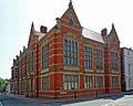
County Hall, Beverley, the headquarters of the council
-
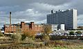
Hull Royal Infirmary


_-_geograph.org.uk_-_606610.jpg)
See also
 In Spanish: Yorkshire del Este para niños
