Pocklington Canal facts for kids
Quick facts for kids Pocklington Canal |
|
|---|---|

The Pocklington Canal
|
|
| Specifications | |
| Maximum boat length | 57 ft 0 in (17.37 m) |
| Maximum boat beam | 14 ft 3 in (4.34 m) |
| Locks | 9 |
| Status | Part Navigable |
| Navigation authority | Canal and River Trust |
| History | |
| Original owner | Pocklington Canal Company |
| Principal engineer | George Leather |
| Date of act | 1815 |
| Date completed | 1818 |
| Date closed | 1934 |
| Date restored | 1971 |
| Geography | |
| Start point | Pocklington |
| End point | East Cottingwith |
| Connects to | River Derwent |
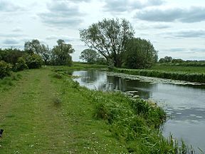
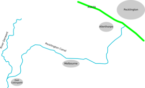
The Pocklington Canal is a wide waterway in the East Riding of Yorkshire, England. It stretches for about 9.5 miles (15.3 km). The canal connects Pocklington to the River Derwent near East Cottingwith. Along its path, boats travel through nine special gates called locks. A big part of the canal is a protected area called a Site of Special Scientific Interest. This means it's important for nature.
Contents
Building the Pocklington Canal
Early Ideas for a Waterway
People first thought about building a canal to Pocklington way back in 1765. They wanted a canal from the Humber Estuary with branches to different towns. Over the years, many plans were made and then dropped. Sometimes, engineers suggested routes that were too long or too expensive.
In 1812, a new plan came forward. A man named George Leather Jr. was asked to survey a route. He worked for Earl Fitzwilliam, who owned land nearby. Leather suggested a route to East Cottingwith. He thought it would cost about £43,630 and have 8 locks. He also suggested extending it into Pocklington for more money.
Starting the Construction
A special law was passed on May 25, 1815, allowing the Pocklington Canal Company to be formed. This company could raise money to build the canal. George Leather became the engineer for the project.
Work began quickly from the River Derwent end. This meant parts of the canal could be used as soon as they were finished. The first section opened in August 1816. The canal was finally completed and opened on July 30, 1818. The total cost was a bit more than planned, around £32,695.
How the Canal Worked
Boats and Locks
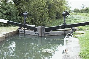
The canal was built wide enough for boats called keels, which were common on the River Derwent. The locks were about 58 feet (17.7 m) long and 14 feet 3 inches (4.34 m) wide. The canal rises about 101 feet (30.8 m) from the Derwent to Pocklington. This meant each lock had to lift boats quite high, over 11 feet (3.4 m) at a time. Most of the water for the canal came from Pocklington Beck.
A house was built for the lock-keeper, who managed the locks and collected money. His name was Mark Swann. At first, the lock handles were fixed, but people sometimes emptied the locks by mistake. So, they changed them to removable handles.
Trade and Money
In 1820, the canal didn't make much money, only £623. This was because roads offered competition for moving goods. However, in 1822, a weekly boat service to Hull began.
- Goods going up the canal to Pocklington: coal, lime, manure, and general items.
- Goods going down the canal to the Derwent: corn, flour, and timber.
As more goods were moved, the canal started to make more money. By 1830, shareholders even received a small payment from the profits. On average, the canal made about £1,400 per year from tolls.
Canal Sold to the Railway
In 1845, a railway company wanted to buy the canal. Another railway company also made an offer. The canal company agreed to sell to whichever railway got permission from the government first.
The York and North Midland Railway got permission in 1846. They opened a railway line connecting towns like Beverley, Market Weighton, Pocklington, and York. In 1848, this railway company bought the Pocklington Canal for £17,980. The railway company was required to keep the canal open.
Decline and Restoration
The Canal's Decline
After the railway bought the canal, they didn't spend much money on keeping it in good shape. They only did very basic repairs. Traffic on the canal slowly decreased. For example, in 1858, 5,721 tons of goods were moved, but by 1892, it was only 901 tons.
The canal became very shallow in places due to silt (mud) building up. Boats could only carry partial loads. Even with these problems, boats continued to use the canal until 1932. The canal remained usable for two more years after that.
Bringing the Canal Back to Life
In the 1960s, people started thinking about restoring the canal. In 1969, the Pocklington Canal Amenity Society was formed. This group wanted to bring the canal back to life.
Restoration work began in 1971. The first job was fixing the entrance lock near East Cottingwith. Over the years, many groups and volunteers helped:
- In 1980, Shell Oil Company helped pay for new gates for Thornton Lock.
- In 1986, the Pocklington Canal Amenity Society provided two new swing bridges.
- The canal up to the Melbourne Arm was officially reopened on July 19, 1987.
Because parts of the canal are a Site of Special Scientific Interest, all restoration work needs approval from Natural England. This ensures that the wildlife and plants are protected.
In 2014, the Waterway Recovery Group helped fix much of the towpath. In 2017, about 1 mile (1.6 km) of the canal was dredged. This meant removing 8,000 tons of silt and reeds. This helps rare water plants and the 15 types of dragonflies and damselflies that live there.
In July 2018, exactly 200 years after it first opened, another section of the canal was reopened for boats. This was between the Melbourne Arm and the Bielby Arm. Grants from the Heritage Lottery Fund and the Inland Waterways Association helped pay for fixing Walbut and Thornton locks.
The Canal Today
The canal society owns a boat called New Horizons. It offers trips for the public during the summer. The Pocklington Canal is also known for its many fish, like tench, bream, perch, and roach. It's a popular spot for fishing.
Restoration work is still happening. By 2020, about 7 miles (11 km) of the canal had been restored. The section from the River Derwent to the Bielby Arm is now open for boats.
Coordinates
| Point | Coordinates (Links to map resources) |
OS Grid Ref | Notes |
|---|---|---|---|
| Canal Head, Pocklington | 53°54′58″N 0°47′02″W / 53.916°N 0.784°W | SE799473 | North terminus |
| Top Lock | 53°54′54″N 0°47′10″W / 53.915°N 0.786°W | SE798471 | |
| Silburn Lock | 53°54′40″N 0°47′17″W / 53.911°N 0.788°W | SE797468 | |
| Giles Lock | 53°54′25″N 0°47′28″W / 53.907°N 0.791°W | SE795463 | |
| Sandhill Lock | 53°54′04″N 0°48′11″W / 53.901°N 0.803°W | SE787457 | |
| Coates Lock | 53°53′49″N 0°48′22″W / 53.897°N 0.806°W | SE785452 | |
| Bielby Arm | 53°53′13″N 0°48′22″W / 53.887°N 0.806°W | SE785440 | Current north terminus |
| Walbut Lock | 53°53′17″N 0°49′41″W / 53.888°N 0.828°W | SE771441 | |
| Thornton Lock | 53°53′24″N 0°50′38″W / 53.890°N 0.844°W | SE761443 | |
| Melbourne Arm | 53°53′24″N 0°51′18″W / 53.890°N 0.855°W | SE753444 | |
| Gardham Lock | 53°53′56″N 0°53′28″W / 53.899°N 0.891°W | SE729453 | |
| Cottingwith Lock | 53°52′34″N 0°56′10″W / 53.876°N 0.936°W | SE700427 | |
| River Derwent | 53°52′26″N 0°56′24″W / 53.874°N 0.940°W | SE697425 | Southern terminus |
 | Valerie Thomas |
 | Frederick McKinley Jones |
 | George Edward Alcorn Jr. |
 | Thomas Mensah |


