
River Ouse, Yorkshire facts for kids
Quick facts for kids River Ouse |
|
|---|---|

The River Ouse in York
|
|
.png)
River Ouse
|
|
| Country | England |
| County | Yorkshire |
| Physical characteristics | |
| Main source | River Ure Cuddy Shaw Reach, near Linton-on-Ouse 33 ft (10 m) 54°2′4″N 1°16′30″W / 54.03444°N 1.27500°W |
| River mouth | Humber Estuary Trent Falls 0 ft (0 m) 53°42′8″N 0°41′46″W / 53.70222°N 0.69611°W |
| Length | 52 mi (84 km) |
| Basin features | |
| Basin size | 4,133 sq mi (10,704 km2) |
The River Ouse (pronounced OOZ) is a river in North Yorkshire, England. It is like a continuation of the River Ure. When you add the length of the River Ure and the River Ouse together, it becomes one of the longest rivers in the UK. It flows for about 129 miles (208 km) in total. The Ouse itself is about 52 miles (84 km) long.
Contents
About the River Ouse
The River Ouse flows through many important places. It passes through the famous city of York. It also goes through the towns of Selby and Goole. Finally, it joins the River Trent at a place called Trent Falls. From there, it flows into the Humber Estuary, which leads to the sea.
Where Does the Ouse Start?
People have different ideas about where the River Ouse truly begins. Some say it starts where the River Ure meets a smaller stream called Ouse Gill Beck. This spot is near Linton-on-Ouse. Others believe the Ouse starts further upstream. They think it begins where the River Swale joins the River Ure. This idea was written about in a newspaper in 1891.
Rivers Joining the Ouse
Many other rivers flow into the Ouse. These are called its tributaries. They include the Derwent, Aire, Don, and Wharfe. Other rivers like the Nidd, Swale, Ure, and Foss also join it. These rivers collect water from a large area. This area includes the Pennines mountains and parts of the Yorkshire Dales and North York Moors.
What's in a Name?
The name "Ouse" is very old. It was first written down around the year 780 as Usa. No one is completely sure where the name comes from. Some experts think it might come from an old Roman-British word meaning "water." Others believe it comes from an even older language called Proto-Celtic.
There's also a theory that the Ouse was once called the "Ure." However, there is no strong proof for this. Another idea suggests the name "Ouse" came from the Roman name for the River Ure, which was Isurā. Over time, this might have changed to Isis and then to Ouse. This could explain why a small stream, Ouse Gill Beck, seems to give its name to the much larger River Ure.
People from Norway and Denmark settled in the York area long ago. So, some parts of local names might come from Old Norse. In Old Norse, the word oss or ouso means "the mouth of a river." This could also be a clue to the name's origin.
Boats and Travel on the Ouse
Boats can travel along the entire length of the River Ouse. Large ships can use the river as far as Howdendyke. The port of Goole is also a busy place for seagoing vessels. From Goole, boats can connect to other waterways like the Aire and Calder Navigation. At Selby, you can access the Selby Canal. The river's water level changes with the tides up to Naburn. This tidal wave is sometimes called "the Aegir."
Locks and Power
At Naburn, there is a special structure called a weir with locks. Locks are like water elevators for boats. They allow boats up to 150 feet (45.7 m) long and 15 feet (4.6 m) wide to reach York. Further upstream, at Linton-on-Ouse, there is another weir and lock. This one lets smaller boats, up to 66 feet (20 m) long, travel onto the River Ure. Next to the lock is the Linton Lock Hydro plant. This plant uses the river's water to make electricity. It can power about 450 homes!
In the past, the Ouse was very busy with trade. Boats carried goods, especially coal, up and down the river. Today, there is still some trade, but the coal business has stopped.
Towns and Villages Along the Ouse
Many towns and villages are located along the River Ouse. Here are some of them, starting from where the Swale and Ure rivers meet:
- Lower Dunsforth
- Aldwark
- Linton-on-Ouse
- Newton-on-Ouse
- Nun Monkton
- Beningbrough
- Overton
- Nether Poppleton
- York
- South Bank
- Fulford
- Bishopthorpe
- Naburn
- Acaster Malbis
- Acaster Selby
- Cawood
- Kelfield
- Riccall
- Barlby
- Selby
- Hemingbrough
- Barmby on the Marsh
- Booth
- Hook
- Skelton
- Goole
- Swinefleet
- Saltmarshe
- Reedness
- Little Reedness
- Yokefleet
- Whitgift
- Blacktoft
- Ousefleet
- Faxfleet
The Ouse then joins the River Trent at Trent Falls to form the Humber Estuary.
When the River Floods
Flooding has been a common problem in areas along the Ouse, especially in York. This is because both the Ouse and the River Foss flow through the city. Floods have happened many times throughout history, including in 1947, 2000, and 2015. In November 2000, the water reached 5.4 metres (18 ft) above sea level. In December 2015, it was 5.2 metres (17 ft) high.
How Flooding is Managed
Heavy rain far upstream in the Ouse's basin causes most floods. This basin covers a huge area of 3,300 square kilometres (1,300 sq mi). In 1989, a barrier was built at the mouth of the River Foss in York. This barrier stops Ouse floodwaters from flowing into the Foss and flooding the city.
Some low-lying areas south of York, like Kelfield and Riccall, are designed to be floodplains. This means they are allowed to flood to protect other areas. In February 2020, over 3,000 acres (1,200 ha) of fields were underwater. This amount of water was similar to the size of Windermere, England's largest natural lake. Since the Ouse is tidal up to Naburn, floods can also happen in towns like Selby and Goole due to heavy rain or high tides.
Images for kids
-
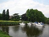
Nun Monkton, north west of York
-
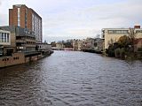
The River Ouse in the city of York
-
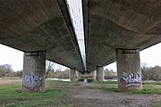
The A64 crossing the River Ouse, Bishopthorpe, York
-
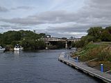
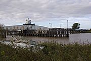
The Marina in Naburn, south of York
-
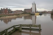
River Ouse at Selby
-
Goole swing rail bridge Goole


See also
 In Spanish: Río Ouse (Yorkshire) para niños
