
River Aire facts for kids
Quick facts for kids River Aire |
|
|---|---|

The River Aire at Gargrave, North Yorkshire
|
|
| Country | England |
| Counties | North Yorkshire, West Yorkshire, East Riding of Yorkshire |
| District | Craven |
| City | Leeds |
| Physical characteristics | |
| Main source | streams above Malham Tarn, North Yorkshire 405 m (1,329 ft) 54°05′49″N 2°11′27″W / 54.0969°N 2.1907°W |
| River mouth | River Ouse Airmyn, East Riding of Yorkshire 5 m (16 ft) 53°43′38″N 0°54′24″W / 53.7272°N 0.9067°W |
| Length | 148 km (92 mi) |
| Basin features | |
| Basin size | 1,004 km2 (388 sq mi) |
| Tributaries |
|
The River Aire is an important river in Yorkshire, England. It flows for about 148 kilometres (92 mi). The river starts high up in the hills and flows down to the sea. From its source at Malham to where it joins another river, it drops about 400 metres (1,300 ft).
A part of the River Aire near Leeds has been changed to make it easier for boats to travel. This changed section is called the Aire and Calder Navigation.
Contents
River's Journey: From Source to Sea
The River Aire begins its journey at Malham Tarn. This is a lake high up in North Yorkshire. The water then flows underground for a short distance. It comes back to the surface at a place called Aire Head, near Malham.
From there, the river flows through towns like Gargrave and Skipton. After passing Cononley, the Aire enters West Yorkshire. Here, it goes through old industrial areas such as Keighley, Bingley, Saltaire, and Shipley.
Next, the river flows through the big city of Leeds. It then continues past villages like Swillington and Woodlesford. At Castleford, the River Aire meets the River Calder. Long ago, a Roman road crossed the river here.
The river then goes back into North Yorkshire near Knottingley. In its lower parts, the Aire forms a border between North Yorkshire and the East Riding of Yorkshire.
Finding the River's True Start
Scientists have done tests to find the exact source of the River Aire. They blocked the flow from Malham Tarn and then released the water. They watched as water surged out at Aire Head and also at the bottom of Malham Cove. The water from Malham Cove took about 30 minutes longer to appear. This shows that water from the tarn feeds both locations.
The area between Malham Tarn and Aire Head is known as Malhamdale. After that, the valley is called Airedale. However, by the time the river reaches Leeds, people usually don't use the name Airedale anymore.
The River Aire finally flows into the River Ouse at Airmyn. The word 'myn' is an old English word meaning 'river mouth'.
Towns and Villages Along the Aire
The River Aire passes through many towns and villages on its way to the River Ouse. Here are some of them:
- Malham
- Hanlith
- Airton
- Bell Busk
- Gargrave
- Skipton
- Low Bradley
- Cononley
- Kildwick
- Silsden
- Steeton
- Utley
- Keighley
- Riddlesden
- Crossflatts
- Bingley
- Saltaire
- Shipley
- Charlestown
- Esholt
- Apperley Bridge
- Horsforth
- Kirkstall
- Leeds city centre
- Holbeck
- Knowsthorpe
- Allerton Bywater
- Castleford
- Brotherton
- Ferrybridge
- Knottingley
- Beal
- West Haddlesey
- Chapel Haddlesey
- Temple Hirst
- Hensall
- Gowdall
- Snaith
- Rawcliffe
- Newland
- Airmyn
Images for kids


-
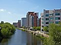
River Aire at Leeds
-
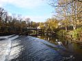
Pollard Bridge, Newlay near Leeds
-
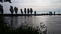
The River Aire as it approaches the River Ouse at Airmyn
-
The meeting point of the River Aire and River Ouse. The Aire comes in from the left.


See also
 In Spanish: Río Aire (Inglaterra) para niños
