
Malham Cove facts for kids
Quick facts for kids Malham Cove |
|
|---|---|
 |
|

Location in North Yorkshire
|
|
| Location | North Yorkshire, England, UK |
| OS grid | SD896639 |
| Coordinates | 54°04′15″N 2°09′31″W / 54.070833°N 2.158611°W |
Malham Cove is a huge, curved rock shape made of limestone. It is located about 1 kilometre (0.6 miles) north of Malham village in North Yorkshire, England. This amazing natural wonder was created over 12,000 years ago. Back then, a giant waterfall poured down here. The water came from meltwater flowing off huge glaciers at the end of the last Ice Age.
Today, Malham Cove is a very popular place to visit. It is part of the beautiful Yorkshire Dales National Park. Above the cove, you can see a large, flat area of rock called a limestone pavement.
Contents
How Malham Cove Was Formed

Malham Cove was carved out by a massive river during the Ice Age. This river plunged over the cliff as a huge waterfall. The waterfall was about 80 metres (260 feet) tall and more than 300 metres (980 feet) wide! The powerful water wore away the rock, especially at the edge. This is what gave the cove its unique curved shape.
Today, the main water flow is usually hidden underground. A stream from Malham Tarn, about 2.4 kilometres (1.5 miles) north, disappears into the ground at a spot called 'Water Sinks'. Another stream, Malham Beck, comes out of a cave at the bottom of the cove.
For a long time, people thought these two streams were connected. But special dye tests showed they are actually separate! They flow underground in different paths. These tests also revealed a complex system of hidden caves and tunnels inside the limestone cliff. This cave system is thought to be around 50,000 years old. Brave cave divers have explored about 1.6 kilometres (1 mile) of these underwater passages.
Usually, the cave systems carry all the water away. So, Malham Cove rarely becomes a waterfall. But on December 6, 2015, after very heavy rain from Storm Desmond, it turned into a waterfall again. This was believed to be the first time in centuries!
History and Activities at Malham Cove
In 1779, a priest named Thomas West described the cove. He said it looked like an "age-tinted wall of a prodigious castle." He admired its white stone and the plants growing from its ledges.
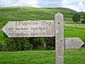
On the west side of the 80-metre (260-foot) high cliff, there are about 400 uneven stone steps. These steps are part of the famous Pennine Way walking trail. They lead up to the rocky limestone pavement at the top.
Malham Cove is also very popular with climbers. It offers many different climbing routes, from easy to very difficult. It's a great place for traditional climbing and sport climbing. In fact, it has one of the hardest sport climbs in the UK! Because the cliff faces south, it's a good spot for climbing in winter. But in summer, the rock can get extremely hot.
Malham Cove in Movies and TV
Malham Cove has appeared in several movies and TV shows:
- It was shown in the BBC TV series Seven Natural Wonders as one of Yorkshire's natural wonders. Nearby Gordale Scar was also featured.
- The limestone pavement was used as a filming location for the 1992 movie Emily Brontë's Wuthering Heights.
- The cove was also seen in the film Harry Potter and the Deathly Hallows (Part 1). Hermione and Harry visited this spot. The scenes were filmed in November 2009.
- The limestone pavement and the area around Malham were featured in an episode of The Trip. This show starred Steve Coogan and Rob Brydon and aired on BBC2 in November 2010.
Images for kids
-
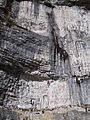
Full cliff face, with climbers for scale
-
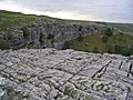
Limestone pavement at the top of the cove
-
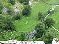
View over cliff edge to Malham Beck below
-
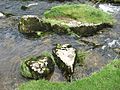
Stones in Malham Beck
-
Pennine Way sign


See also
 In Spanish: Malham Cove para niños
