
Pennine Way facts for kids
Quick facts for kids Pennine Way |
|
|---|---|

View from the Pennine Way, near Marsden
|
|
| Length | 268 miles (431 km) |
| Location | Northern England and southern Scotland, United Kingdom |
| Designation | UK National Trail |
| Trailheads | Edale, Derbyshire Kirk Yetholm, Scottish Borders |
| Use | Hiking |
| Highest point | Cross Fell, 893 m (2,930 ft) |
| Difficulty | Moderate to Strenuous |
| Season | All year |
| Hazards | Severe weather |
The Pennine Way is a super long walking path in England, with a tiny bit going into Scotland. It's a special route called a National Trail. This amazing path stretches for about 268 miles (431 km)! That's like walking from one end of a country to another.
It starts in Edale, a village in the Peak District in Derbyshire. From there, it heads north through the beautiful Yorkshire Dales and Northumberland National Park. The journey ends at Kirk Yetholm, which is just over the Scottish border.
The path follows the Pennine hills. People sometimes call these hills the "backbone of England" because they run down the middle of the country. While it's not the longest National Trail in the UK, it's known as one of the toughest and most famous.
History of the Pennine Way

The idea for the Pennine Way came from a journalist and walker named Tom Stephenson. He was inspired by long trails in the United States, like the Appalachian Trail. In 1935, Stephenson wrote an article suggesting the idea. He worked hard to convince the government to create an official trail.
The original plan was for the walk to finish at Wooler. However, it was later decided that Kirk Yetholm would be the end point. The final part of the path was officially opened on April 24, 1965. A special ceremony took place on Malham Moor.
Before the path opened, the British Army helped test the route. Young soldiers from the Army Catering Corps were split into small groups. Each group walked about 15 miles (24 km) of the path. They then reported on the signs and if the route was easy to follow.
In April 2015, the Pennine Way celebrated its 50th birthday! The BBC One even showed a four-part TV series about the trail.
Walking the Pennine Way
.jpg)
The Pennine Way is very popular with walkers. In 1990, a report said that 12,000 people walked the whole trail each year. Many more, about 250,000, walked just parts of it. These walkers helped the local economy by spending money along the route.
Because so many people walk the trail, some parts of the ground have worn away. To fix this, steps have been taken to protect the path. Some sections were moved to stronger ground. Also, flat stones or wooden walkways, called duckboards, were put down in muddy areas. These efforts have helped a lot, even though some people felt they changed the natural look of the landscape.
Where to Stay on the Trail
You can find places to stay along the Pennine Way. These include Youth Hostels, campsites, bed and breakfasts, and pubs. However, there aren't many places to stay in the higher, more remote areas.
This means you might have to choose between a very long day of walking. Or you could have two shorter days, but you'd need to walk off the main path to a nearby village for the night. Then you would walk back up to the path the next morning.
Accessing the Trail
The Pennine Way has 535 points where it connects with other public walking paths. Many roads cross the route, and it passes through villages and towns with good public transport. This makes it easy to walk just a small part of the trail. You can also split the whole Pennine Way into several shorter holidays or long weekends.
Most of the Pennine Way is for walkers only. It's not usually open for people on horseback or bicycles. But there is a path called the Pennine Bridleway that runs roughly next to it. This path is open to anyone not using motor vehicles. It starts a little further south than the Pennine Way.
The Pennine Way is also used for a tough race called the Spine Race. This race started in 2012. The fastest time to complete the entire Way is 2 days, 13 hours, and 34 minutes. This record was set by Damian Hall in July 2020. The fastest woman, Sabrina Verjee, finished it in 3 days, 2 hours, and 28 minutes in September 2020.
The Pennine Way Route
A study by the National Trails agency found that if you walk the whole trail, you'll go through 287 gates. You'll also cross 249 wooden stiles and 183 stone stiles. Plus, there are 204 bridges!
About 198 miles (319 km) of the route is on public footpaths. Another 70 miles (112 km) is on public bridleways. The rest, about 20 miles (32 km), is on other public roads. To help walkers, there are 458 special signs called waymarks along the path.
Peak District National Park Section

The Pennine Way starts in Edale. It used to go straight up the middle of the Kinder Scout plateau. But to stop the ground from wearing away, the path was changed. Now, it goes west and climbs onto the plateau using steps called Jacob's Ladder.
Then, it turns north. It follows the western edge of the plateau past Kinder Downfall. It crosses the Snake Pass road (A57) and climbs Bleaklow. From the top, the trail goes down into Longdendale. Here, it crosses the dam of Torside Reservoir to Crowden. This is the first village you'll reach since the start, about 16 miles (26 km) away.
From Crowden, the Pennine Way climbs a side valley. It goes past Laddow Rocks to the top of Black Hill. This hill is on the border of Yorkshire. The path then goes down across Wessenden Head Moor. It crosses the A635 road and goes into the Wessenden Valley. Finally, it climbs out of the valley and leaves the National Park at Standedge on the A62 road.
South Pennines Section

From Standedge, the Pennine Way follows the border between Yorkshire and Greater Manchester. It goes north along a line of rocky edges. It crosses the A640 road, then the A672. After that, it crosses the M62 motorway using a long footbridge near Windy Hill.
Past the motorway, the trail follows Blackstone Edge to the A58 road. Then it passes several reservoirs. It crosses the Calderdale Way high above the village of Mankinholes. Next, it climbs to the tall monument on Stoodley Pike. From the monument, it goes steeply down to the River Calder valley. It crosses the river about 1 mile (1.6 km) west of Hebden Bridge. This is the biggest town near the route.
The trail climbs out of the Calder valley through the small village of Colden. It crosses Colden Water using an old stone bridge. Then it passes the Walshaw Dean Reservoirs and climbs to the ruins of Top Withens. People say this place inspired the book Wuthering Heights. The trail then goes down to Ponden Hall. It crosses more moorland to the villages of Cowling and Lothersdale.
From Lothersdale, the trail crosses Pinhaw Beacon to Thornton-in-Craven. After this, the landscape becomes gentler. There's a short part of the path along the Leeds and Liverpool Canal at East Marton. Finally, it reaches the village of Gargrave in Airedale, which is on the busy A65.
Yorkshire Dales National Park Section

North of Gargrave, the Pennine Way goes up Airedale and enters the Yorkshire Dales National Park. It follows paths through fields, passing through the small villages of Airton and Hanlith. Then it reaches the larger village of Malham.
Next, it climbs steps on the west side of Malham Cove. It walks across the flat, rocky ground at the top of the cove. It continues north to Malham Tarn. The trail then crosses a part of Fountains Fell. It crosses the top of Silverdale and climbs the steep side of Pen-y-Ghent. From the top of Pen-y-Ghent, the Pennine Way goes down to the village of Horton in Ribblesdale. This village is on the Settle–Carlisle Railway.
The Pennine Way then heads up Ribblesdale. It follows an old packhorse road. It passes the eastern end of Ling Gill and climbs Cam Fell. Here, it follows the line of a Roman road, which is also part of the Dales Way. The trail then passes Dodd Fell Hill and follows a ridge. Finally, it goes down into Wensleydale at Gayle and the nearby town of Hawes.
The path crosses the valley to Hardraw. Then it starts a 5-mile (8 km) climb up Great Shunner Fell. From the top of the fell, the trail goes down to upper Swaledale and the village of Thwaite. It then crosses the side of Kisdon, offering great views down Swaledale. It passes Kisdon Force, a waterfall on the River Swale, and reaches the village of Keld.
From Keld, the path crosses the route of the Coast to Coast Walk. Then it climbs a side valley called Stones Dale to reach Tan Hill and its famous isolated inn. This is at the northern edge of the National Park.
North Pennines Section

At Tan Hill, the Pennine Way enters the North Pennines AONB. It follows paths across the moorland to a lonely place called Sleightholme. Here, the route splits into two. The main path goes straight north across the moors. It crosses God's Bridge and goes under the A66 road through a tunnel. The other path goes into the town of Bowes and joins the main route again at Baldersdale.
From Baldersdale, the trail crosses Lunedale and goes down to the small town of Middleton-in-Teesdale. From Middleton, the path climbs up Teesdale along the right side of the River Tees. It passes the waterfalls of Low Force and High Force. Then it reaches the spread-out village of Forest-in-Teesdale. Further up the Tees, the path climbs next to the waterfall of Cauldron Snout. This is below the dam of Cow Green Reservoir.
The trail then goes up the gently rising valley of Maize Beck. It reaches High Cup Nick, which is one of the most photographed spots on the Pennine Way. From High Cup, the trail goes down to the village of Dufton.
From Dufton, the Pennine Way climbs back up the hills. It passes the tops of Knock Fell, Great Dun Fell, Little Dun Fell, and finally Cross Fell. At 893 metres (2,930 ft), Cross Fell is the highest point on the entire path. Here, walkers can face tough conditions in bad weather because of the strong Helm Wind. A long downhill walk follows to the valley of the South Tyne at Garrigill. The trail then stays close to the river to enter the town of Alston.
The trail continues down the South Tyne valley to Slaggyford and Knarsdale. Above the village of Lambley, the trail leaves the valley. It crosses more moorland to the A69 near the village of Greenhead.
Northumberland National Park and Scottish Border Section

Outside Greenhead, the Pennine Way passes Thirlwall Castle on Hadrian's Wall. For the next 11 miles (18 km), the route is the same as the Hadrian's Wall Path. It follows the wall closely past Once Brewed to Rapishaw Gap. This is about 1 mile (1.6 km) west of the Housesteads Roman Fort.
From the wall, the trail heads north through Wark Forest. After the forest, it follows paths through fields to Shitlington Crags. It then goes down to the large village of Bellingham. More remote countryside follows, crossing Padon Hill and the edge of Redesdale Forest. The trail eventually reaches Redesdale at Blakehopeburnhaugh and Cottonshopeburnfoot. These are two nearby small places that compete for having the longest name in England! The route then follows the River Rede upstream to the village of Byrness.
The last part of the Pennine Way crosses the Cheviot Hills. This section, from Byrness to Kirk Yetholm, is 27 miles (43 km) long. There are no villages or towns along this part. People usually walk it in one long day, but there are two small refuge huts, called bothies, where you can rest.
The trail climbs steeply from Byrness. Then it heads north to cross the Scottish border near Ogre Hill. For the rest of this section, the path switches between England and Scotland. It follows a fence that marks the border itself. Back in England, the trail passes the Roman fort at Chew Green. It briefly follows the Roman road of Dere Street.
The path then follows the border ridge, passing the high point of Windy Gyle. At the west top of Cairn Hill (743 metres (2,438 ft)), the path leads to the top of The Cheviot and back down. The path then turns sharply northwest with the border fence. It goes down to a refuge hut before climbing The Schil at 601 metres (1,972 ft), above the College Valley. The path then goes down into Scotland and enters the village of Kirk Yetholm. The Pennine Way officially ends at the Border Hotel there.
Images for kids
-
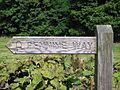
A waymark at Airton
-
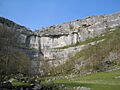
The limestone cliff at Malham Cove
-
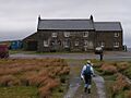
Tan Hill Inn
-
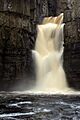
High Force waterfall
-
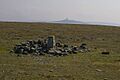
The Summit of Cross Fell, the highest point of the Pennines
-
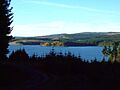
The Pennine Way passes through parts of the Kielder Forest
-
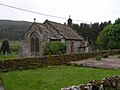
The Church at Byrness


