
River Tyne facts for kids
Quick facts for kids River Tyne |
|
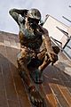
 River Tyne Quayside
|
|
| Country | United Kingdom |
|---|---|
| Part | England |
| Tributaries | |
| - left | River Derwent |
| Primary source | South Tyne |
| - location | Alston Moor |
| Secondary source | North Tyne |
| - location | Deadwater Fell, Kielder, Northumberland |
| Mouth | Tynemouth |
| - location | South Shields |
| - coordinates | 55°0′37″N 1°25′8″W / 55.01028°N 1.41889°W |
| Length | 321.4 km (200 mi) |
| Basin | 2,933 km² (1,132 sq mi) |
| Discharge | for Bywell |
| - average | 44.6 m³/s (1,575 cu ft/s) |
The River Tyne is an important river in North East England. Many people enjoy water sports on it, especially in the summer. Over 43,500 visitors come to see the river and its famous sights each year. Two well-known bridges cross the Tyne: the Tyne Bridge and the Millennium Bridge. These bridges connect the towns of Gateshead and Newcastle upon Tyne.
Contents
Where the River Tyne Starts
The River Tyne is formed by two smaller rivers joining together. These are the North Tyne and the South Tyne.
The South Tyne
The South Tyne begins in a place called Alston Moor. This area is in Cumbria, a county in England. It flows north through beautiful countryside.
The North Tyne
The North Tyne starts further north, near Deadwater Fell. This is close to Kielder Forest in Northumberland. It also flows south, getting ready to meet the South Tyne.
Where They Meet
The North Tyne and South Tyne meet near a village called Warden. This meeting point is known as Watersmeet. From here, the river becomes the main River Tyne.
The Journey of the River Tyne
After the two rivers join, the River Tyne flows east towards the sea. It travels through several towns and cities.
Length and Size
The River Tyne is about 321.4 kilometers (around 200 miles) long. Its watershed, which is the area of land that drains into the river, covers about 2,933 square kilometers. This means a lot of rain and water from this large area ends up in the Tyne.
Cities Along the River
The river passes through many important places. The most famous cities on its banks are Newcastle upon Tyne and Gateshead. These cities are connected by several bridges.
Reaching the Sea
The River Tyne finally flows into the North Sea at Tynemouth. This is a coastal town where the river's journey ends. The mouth of the river is also near South Shields.
Famous Bridges of the Tyne
The River Tyne is well-known for its many bridges. These bridges are not just for crossing; they are also famous landmarks.
The Tyne Bridge
The Tyne Bridge is one of the most famous symbols of Newcastle. It's a large arch bridge, similar to the Sydney Harbour Bridge in Australia. It was opened in 1928.
The Millennium Bridge
The Gateshead Millennium Bridge is a newer and very unique bridge. It's a tilting bridge, meaning it can tilt to let ships pass underneath. It looks like a blinking eye when it moves. This bridge was opened in 2001.
What the River Tyne is Used For
The River Tyne has been important for many reasons throughout history. Today, it's used for different activities.
Water Sports and Tourism
In the summer, the river is popular for water sports like rowing and kayaking. Many people visit the Quayside area in Newcastle and Gateshead. They enjoy walking along the river and seeing the famous bridges.
History and Industry
In the past, the River Tyne was very important for shipping and coal mining. Coal from nearby mines was transported down the river. Many ships were also built along its banks. While these industries have changed, the river remains a vital part of the region's heritage.
Images for kids
-
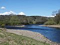
Confluence of North (right) and South Tyne (left) near Warden
-
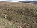
A stone marker shows the source of the River North Tyne
-
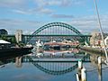
The Tyne Bridge across the River Tyne between Newcastle upon Tyne and Gateshead. Taken from the deck of the Gateshead Millennium Bridge, looking west and upstream.
-
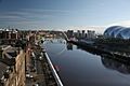
The River Tyne flowing through Newcastle upon Tyne
-
River God Tyne by David Wynne at Newcastle Civic Centre


See also
 In Spanish: Río Tyne para niños
