
Tynemouth facts for kids
Quick facts for kids Tynemouth |
|
|---|---|
 Front Street, Tynemouth |
|

Tynemouth
|
|
| Population | 60,605 (Built-up area, 2021) |
| OS grid reference | NZ367694 |
| Metropolitan borough |
|
| Metropolitan county | |
| Region | |
| Country | England |
| Sovereign state | United Kingdom |
| Post town | NORTH SHIELDS |
| Postcode district | NE30 |
| Dialling code | 0191 |
| Police | Northumbria |
| Fire | Tyne and Wear |
| Ambulance | North East |
| EU Parliament | North East England |
| UK Parliament |
|
Tynemouth (/ˈtaɪnmaʊθ/) is a cool coastal town in Tyne and Wear, England. It's located on the north side of where the River Tyne meets the North Sea. This is how it got its name! Tynemouth is about 13 kilometers (8 miles) east-northeast of Newcastle upon Tyne. The old Tynemouth Priory and Castle stands on a high piece of land. It looks out over both the river mouth and the sea. The town center is just west of this historic spot.
Tynemouth was part of Northumberland until 1974. It used to be a large area that included the nearby town of North Shields. In 2021, the Tynemouth area, which includes North Shields, had a population of 60,605 people.
Exploring Tynemouth's Past

The high land overlooking the River Tyne has been lived on since the Iron Age. The Romans might have used it as a signal station. In the 600s, a monastery was built in Tynemouth. It was later made stronger like a castle. This area was known as Pen Bal Crag.
The place where now stands the Monastery of Tynemouth was anciently called by the Saxons Benebalcrag
The Danes attacked the monastery in 800 and again in 875. But by 1083, it was working again. Three kings are said to be buried there:
- Oswin, King of Deira (651)
- Osred II, King of Northumbria (792)
- Malcolm III, King of Scots (1093)
You can still see three crowns on the North Tyneside coat of arms today!
Queens of King Edward I and King Edward II stayed at the Castle and Priory. This was when their husbands were fighting in Scotland. King Edward III thought it was one of the strongest castles in the north. After the Battle of Bannockburn in 1314, Edward II escaped from Tynemouth by ship.
A village grew up near the fortified Priory. Around 1325, the leader of the Priory built a port for fishing and trade. This caused a long argument with Newcastle upon Tyne about shipping rights on the Tyne.
Prince Rupert of the Rhine arrived in Tynemouth in August 1642. He was on his way to fight in the English Civil War.
Tynemouth was an old parish divided into eight areas called townships. These included North Shields and Whitley. In the 1800s, North Shields grew quickly. It became larger than Tynemouth itself.
In 1832, a special area for voting in Parliament was created. It was called Tynemouth and North Shields. In 1849, this same area became a municipal borough. It was simply called Tynemouth, even though North Shields was bigger. The first town clerk was Thomas Carr Leitch.
The local council met at Tynemouth Town Hall in North Shields. In 1904, Tynemouth became a county borough. This meant it managed its own local government. But it was still part of Northumberland for legal reasons. In 1974, the county borough was ended. The area then became part of North Tyneside in the new metropolitan county of Tyne and Wear.
In 2018, Tynemouth was named one of the best places to live in Northern England.
Tynemouth's Weather
Tynemouth has a mild oceanic climate. This is because it's right next to the North Sea. Summers are not too hot, with temperatures around 18°C (64°F). Winters are quite mild for a northern English place. The area gets about 1515 hours of sunshine each year. It also has a moderate amount of rain, around 597.2 mm (23.5 inches) per year.
| Climate data for Tynemouth (1991–2020) | |||||||||||||
|---|---|---|---|---|---|---|---|---|---|---|---|---|---|
| Month | Jan | Feb | Mar | Apr | May | Jun | Jul | Aug | Sep | Oct | Nov | Dec | Year |
| Mean daily maximum °C (°F) | 7.4 (45.3) |
7.9 (46.2) |
9.3 (48.7) |
10.8 (51.4) |
13.3 (55.9) |
16.0 (60.8) |
18.4 (65.1) |
18.3 (64.9) |
16.2 (61.2) |
13.5 (56.3) |
10.0 (50.0) |
7.7 (45.9) |
12.4 (54.3) |
| Mean daily minimum °C (°F) | 2.5 (36.5) |
2.5 (36.5) |
3.5 (38.3) |
5.1 (41.2) |
7.3 (45.1) |
10.3 (50.5) |
12.5 (54.5) |
12.4 (54.3) |
10.6 (51.1) |
7.8 (46.0) |
5.1 (41.2) |
2.8 (37.0) |
6.9 (44.4) |
| Average rainfall mm (inches) | 45.8 (1.80) |
40.8 (1.61) |
39.2 (1.54) |
43.4 (1.71) |
41.5 (1.63) |
55.7 (2.19) |
51.8 (2.04) |
64.4 (2.54) |
45.2 (1.78) |
55.2 (2.17) |
70.5 (2.78) |
54.7 (2.15) |
608.3 (23.95) |
| Average rainy days (≥ 1 mm) | 10.4 | 9.2 | 7.8 | 8.2 | 8.5 | 9.8 | 9.7 | 9.9 | 8.6 | 11.4 | 12.2 | 10.7 | 116.3 |
| Mean monthly sunshine hours | 63.1 | 85.6 | 123.5 | 160.8 | 200.2 | 185.7 | 187.4 | 174.2 | 141.8 | 103.8 | 68.7 | 56.1 | 1,551.1 |
| Source: Met Office | |||||||||||||
Fun Things to Do in Tynemouth
Amazing Beaches
.jpg)
In the late 1700s, people started enjoying sea-bathing at Tynemouth's beaches. Today, King Edward's Bay and Tynemouth Longsands are very popular. Locals and tourists love them.
King Edward's Bay is a small beach north of the Priory. Cliffs protect it on three sides. You can reach it by stairs. Longsands is the next beach north. It's a huge stretch of fine sand, about 1200 yards long. It's located between the old Tynemouth outdoor swimming pool and Cullercoats. The outdoor pool opened in 1925 and was a big attraction.
.jpg)
In 2013, users of TripAdvisor voted Longsands one of the best beaches in the UK. It was ranked the UK's fourth favorite beach. It was also voted the 12th best in Europe!
.jpg)
Prior's Haven is a small beach inside the mouth of the Tyne. It's sheltered between the Priory and the Spanish Battery. It was popular with bathers in Victorian times. Now, it's home to the Tynemouth Rowing Club and the local sailing club.
Front Street and Memorials
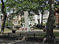
A statue of Queen Victoria stands on the Village Green. It was revealed in 1902. The green also has memorials for Tynemouth residents. These are for those lost in the Second Boer War (1899–1902). A larger central memorial is made of white granite. It honors those lost in both World Wars. It was unveiled in 1923. Names from World War II were added in 1999.
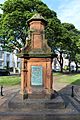
The Tynemouth Clock Tower on Front Street was built in 1861. It was designed by Oliver and Lamb. The tower has a clock by Joyce of Whitchurch. At ground level, there were drinking fountains for people and dogs. There was also a weather barometer. The tower is made of colorful bricks and stone. It's in the Venetian Gothic style. It has been a protected building since 1986.
Kings Priory School

Kings Priory School is on Huntingdon Place. It's a school for boys and girls aged 4 to 18. The school started in Jarrow in 1860. It moved to Tynemouth in 1865. It used to be a private school. In 2013, it joined with a local primary school. It became a state academy.
The school was named after the three kings buried at Tynemouth Priory. Its most famous former student is Stan Laurel. He was one half of the comedy duo Laurel and Hardy. Famous film director Sir Ridley Scott also went to this school.
Tynemouth Pier and Lighthouse

| Year first constructed | 1864 (first) |
|---|---|
| Year first lit | 1903 (current) |
| Tower shape | tapered cylindrical tower with balcony and lantern |
| Original lens | rotating catadioptric lens (6 panels in 2 groups of 3) |
| Fog signal | 1 blast every 10s. |
This huge stone wall goes out into the sea for about 810 meters (900 yards). It protects the north side of the Tyne's mouth. There's a wide walkway on top, which is great for walks. At the end of the pier is a lighthouse.
Building the pier took over 40 years (1854–1895). In 1898, a big storm damaged the pier. It was then rebuilt in a straighter line and finished in 1909. There's another pier at South Shields that protects the south side of the river mouth.

A new lighthouse was built by Trinity House starting in 1903. It was first lit on January 15, 1908. The light flashes three times every ten seconds. It was very powerful, with a range of 15 nautical miles. It also had a loud fog signal. The lighthouse became automatic in 1967.
Before the pier, a lighthouse stood near Tynemouth Priory and Castle. It was taken down in 1898. On October 20, 2023, the top of the lighthouse was damaged by Storm Babet.
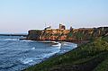
The Spanish Battery

This high point of land is also known as Freestone Point. Old settlements from the Iron Age have been found here. The name "Spanish Battery" comes from Spanish soldiers. They supposedly used guns here in the 1500s to protect King Henry VIII's ships. Most of the guns were gone by 1905. Today, it's a great spot to watch ships on the Tyne.
The Collingwood Monument
.jpg)
Beyond the Spanish Battery is a huge memorial to Lord Collingwood. He was Nelson's second-in-command at the Battle of Trafalgar. Collingwood finished the victory after Nelson was killed. The monument was built in 1845. It was designed by John Dobson. The statue of Collingwood is 23 feet tall. It stands on a large base with steps. Four cannons from HMS Royal Sovereign, Collingwood's ship, are also there.
The Black Middens
These rocks are in the Tyne near the Monument. They are covered when the tide is high. One rock, called Priors Stone, can sometimes be seen. Over many years, these rocks caused many ships to crash. In 1864, five ships crashed in three days, and many people died. This led to the creation of the Tynemouth Volunteer Life Brigade. This group helps the Coastguard during sea disasters.
Tynemouth Aquarium

The Tynemouth Aquarium is an undersea park. It has seahorses, sharks, giant octopuses, frogs, otters, and many other creatures. Its Seal Cove is a special outdoor area. It's home to a group of harbor seals born in captivity. The 500,000-liter pool has rocky areas and underwater caves. These are made to keep the seals in conditions close to nature. It used to be called the Blue Reef Aquarium Tynemouth.
Getting Around Tynemouth
Tynemouth Metro station connects Tynemouth to Newcastle. It opened in 1882 as a main train station. It served thousands of holiday-makers going to Tynemouth's beaches. Its fancy Victorian ironwork roofs are protected as a Grade II listed building. They were fixed up in 2012. Now, the station hosts a weekend "flea market." It also has book fairs, craft shows, coffee shops, and other events.
Tynemouth is also the end point for the 140-mile long Coast to Coast Cycle Route. This route starts in Whitehaven or Workington in Cumbria.
Tynemouth's People
In 2011, Tynemouth had a population of 67,519. This number is higher than in 2001. This is mainly because the area's boundaries changed. For example, North Shields was counted separately in 2001. The 2011 definition of Tynemouth includes North Shields and other areas like Shiremoor. If we use the 2011 boundaries, Tynemouth had a population of 60,881 in 2001. So, Tynemouth has grown in both size and population.
| Tynemouth | North Tyneside | |
|---|---|---|
| White British | 94.7% | 95.1% |
| Asian | 2.0% | 1.9% |
| Black | 0.3% | 0.4% |
Places of Worship
Tynemouth's main church is the Church of the Holy Saviour. It was built in 1841. In Front Street, there were two other churches. One was the Catholic Parish of Our Lady & St Oswin's, opened in 1899. The other was Tynemouth Congregational Church, which closed in 1973. It is now a shopping area.
Famous People from Tynemouth
- Susan Mary Auld – a naval architect.
- Norah Balls (1886–1980) – a suffragette and women’s rights campaigner. She helped start the Girl Guides in Northumberland.
- Thomas Bewick – an engraver who wrote much of his life story here.
- Toby Flood – an England rugby player who went to The King's School.
- Andy Taylor – lead guitarist for the band Duran Duran, born in Tynemouth in 1961.
- John of Tynemouth (canon lawyer) – a lawyer and teacher from the 1200s.
- John of Tynemouth (chronicler) – a writer of history from the 1300s.
- John of Tynemouth (geometer) – a writer on geometry from the early 1200s.
Famous Visitors to Tynemouth
Charles Dickens visited Tynemouth in 1867. He wrote about a stormy sea walk. He said a huge wave knocked him over and soaked him!
Giuseppe Garibaldi sailed into the River Tyne in 1854. He briefly stayed in Huntingdon Place. A special plaque marks the house.
Lewis Carroll visited Tynemouth in 1855. He wrote about meeting "three nice little children" there.
Algernon Charles Swinburne visited in 1862. He recited his poems while walking by the sea.
Peter the Great of Russia is said to have stayed briefly in Tynemouth. He was visiting secretly to learn about shipbuilding.
Festivals and Events
Mouth of the Tyne Festival
The Mouth of the Tyne Festival is a yearly free event. It's held in Tynemouth and South Shields. It includes a big outdoor concert at Tynemouth Priory.
Tynemouth Pageant
The Tynemouth Pageant is a community group. Every three years, they put on an outdoor play. It happens in the grounds of Tynemouth Castle and Priory. This is allowed by English Heritage, who manage the historic site.
Images for kids
-
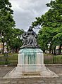
The Statue of Queen Victoria
-
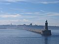
Tynemouth Pier
-
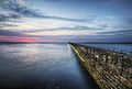
Tynemouth Pier looking out to the North Sea
-
Tynemouth War Memorial
-
Tynemouth Boer War Memorial
-
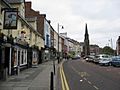
The view of Front Street from the Salutation Inn
-
King Edward's Bay with Tynemouth Priory above the cliff
-
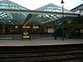
Tynemouth Metro Station
-
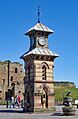
Tynemouth Clock Tower


.jpg)


.jpg)


