
Tyne and Wear facts for kids
Quick facts for kids
Tyne and Wear
|
|||||||||||||||||||||||||||||||||||
|---|---|---|---|---|---|---|---|---|---|---|---|---|---|---|---|---|---|---|---|---|---|---|---|---|---|---|---|---|---|---|---|---|---|---|---|
|
The Angel of the North, Souter Lighthouse in Whitburn, and the River Tyne between Gateshead and Newcastle.
|
|||||||||||||||||||||||||||||||||||

Tyne and Wear within England
|
|||||||||||||||||||||||||||||||||||
| Sovereign state | United Kingdom | ||||||||||||||||||||||||||||||||||
| Constituent country | England | ||||||||||||||||||||||||||||||||||
| Region | North East | ||||||||||||||||||||||||||||||||||
| Established | 1974 | ||||||||||||||||||||||||||||||||||
| Established by | Local Government Act 1972 | ||||||||||||||||||||||||||||||||||
| Preceded by |
|
||||||||||||||||||||||||||||||||||
| Time zone | UTC±00:00 (Greenwich Mean Time) | ||||||||||||||||||||||||||||||||||
| • Summer (DST) | UTC+01:00 (British Summer Time) | ||||||||||||||||||||||||||||||||||
| Members of Parliament | 11 MPs | ||||||||||||||||||||||||||||||||||
| Police | Northumbria Police | ||||||||||||||||||||||||||||||||||
| Largest city | Newcastle upon Tyne | ||||||||||||||||||||||||||||||||||
|
|||||||||||||||||||||||||||||||||||


Tyne and Wear is a special county in North East England. It shares borders with Northumberland to the north and County Durham to the south. The biggest city in the county is Newcastle upon Tyne.
Tyne and Wear is mostly a city area. In 2021, about 1.14 million people lived there. After Newcastle, the largest cities and towns are Sunderland, Gateshead, and South Shields. Most places in Tyne and Wear are part of big city areas called Tyneside or Wearside.
The county has five main areas called metropolitan boroughs. These are Gateshead, Newcastle upon Tyne, Sunderland, North Tyneside, and South Tyneside. All these boroughs work together as part of the North East Combined Authority.
Tyne and Wear was created in 1974. Before that, its land was part of Northumberland and County Durham. The River Tyne used to be the border between these two older counties. The county council for Tyne and Wear was closed in 1986, but the county itself still exists.
The most important natural features are the River Tyne and River Wear. The county is named after these rivers, and its main towns grew up along them. The county also has a coastline along the North Sea in the east. This coast has tall limestone cliffs and wide beaches.
Contents
A Look at History
Around the late 600s and 700s, a monk named Saint Bede lived in a monastery here. He wrote important histories about the Early Middle Ages, including the Ecclesiastical History of the English People.
About 150 years ago, Souter Lighthouse was built in the village of Marsden. This was the first lighthouse in the world to be powered by electricity!
In 1888, some towns like Newcastle upon Tyne, Gateshead, and Sunderland became "county boroughs." This meant they could manage their own affairs. Later, Tynemouth also became one. Other towns in the area were part of the larger counties of Durham and Northumberland.
People realized that local government in the Tyneside area needed to be updated. In 1935, a special group was formed to study the area. They looked at how local government worked around the River Tyne. Their goal was to find ways to make things more efficient and save money.

In 1937, this group suggested creating a new "Northumberland Regional Council." This council would handle services for a larger area. They also thought about combining smaller towns and boroughs. One idea was to create a single big city called "Newcastle-on-Tyneside." However, these ideas never happened because the local councils couldn't agree.
Later, in 1972, a new law was made to change local government. It suggested a new county that would include Newcastle and Sunderland. At first, they wanted to call it "Tyneside." But people in Sunderland didn't like that name because it didn't include their area. So, they asked for the name to be changed to "Tyne and Wear," which was then approved.
Geography and Climate
What's the Weather Like?
Tyne and Wear has two official weather stations nearby. One is in Tynemouth, right by the sea, and the other is inland in Durham. Both places have an oceanic climate, which means they have cool summers and mild winters. You can see the average temperatures and rainfall below.
| Climate data for Tynemouth 33 m asl, 1981–2010 | |||||||||||||
|---|---|---|---|---|---|---|---|---|---|---|---|---|---|
| Month | Jan | Feb | Mar | Apr | May | Jun | Jul | Aug | Sep | Oct | Nov | Dec | Year |
| Mean daily maximum °C (°F) | 7.2 (45.0) |
7.3 (45.1) |
9.0 (48.2) |
10.3 (50.5) |
12.7 (54.9) |
15.6 (60.1) |
18.1 (64.6) |
18.1 (64.6) |
16.1 (61.0) |
13.2 (55.8) |
9.7 (49.5) |
6.4 (43.5) |
12.1 (53.8) |
| Mean daily minimum °C (°F) | 2.2 (36.0) |
2.2 (36.0) |
3.3 (37.9) |
4.8 (40.6) |
7.2 (45.0) |
10.0 (50.0) |
12.3 (54.1) |
12.3 (54.1) |
10.4 (50.7) |
7.7 (45.9) |
4.9 (40.8) |
2.5 (36.5) |
6.7 (44.1) |
| Average precipitation mm (inches) | 45.5 (1.79) |
37.8 (1.49) |
43.9 (1.73) |
45.4 (1.79) |
43.2 (1.70) |
51.9 (2.04) |
47.6 (1.87) |
59.6 (2.35) |
53.0 (2.09) |
53.6 (2.11) |
62.8 (2.47) |
53.9 (2.12) |
597.2 (23.51) |
| Mean monthly sunshine hours | 61.1 | 81.6 | 117.7 | 149.9 | 191.7 | 183.0 | 185.7 | 174.9 | 174.1 | 106.2 | 70.4 | 51.9 | 1,515 |
| Source: Met Office | |||||||||||||
| Climate data for Durham 102m asl, 1981–2010, extremes 1850– | |||||||||||||
|---|---|---|---|---|---|---|---|---|---|---|---|---|---|
| Month | Jan | Feb | Mar | Apr | May | Jun | Jul | Aug | Sep | Oct | Nov | Dec | Year |
| Record high °C (°F) | 16.7 (62.1) |
17.4 (63.3) |
21.7 (71.1) |
24.1 (75.4) |
27.8 (82.0) |
30.6 (87.1) |
31.0 (87.8) |
32.5 (90.5) |
30.0 (86.0) |
25.0 (77.0) |
19.4 (66.9) |
15.9 (60.6) |
32.5 (90.5) |
| Mean daily maximum °C (°F) | 6.6 (43.9) |
7.2 (45.0) |
9.5 (49.1) |
11.9 (53.4) |
15.0 (59.0) |
17.6 (63.7) |
20.1 (68.2) |
19.8 (67.6) |
17.2 (63.0) |
13.3 (55.9) |
9.4 (48.9) |
6.7 (44.1) |
12.9 (55.2) |
| Mean daily minimum °C (°F) | 0.9 (33.6) |
0.9 (33.6) |
2.3 (36.1) |
3.7 (38.7) |
6.1 (43.0) |
9.0 (48.2) |
11.1 (52.0) |
11.0 (51.8) |
9.0 (48.2) |
6.3 (43.3) |
3.4 (38.1) |
1.1 (34.0) |
5.4 (41.7) |
| Record low °C (°F) | −17.2 (1.0) |
−18.3 (−0.9) |
−15 (5) |
−11.1 (12.0) |
−4.4 (24.1) |
−1.1 (30.0) |
1.1 (34.0) |
0.6 (33.1) |
−1.1 (30.0) |
−5.5 (22.1) |
−8.8 (16.2) |
−16.6 (2.1) |
−18.3 (−0.9) |
| Average rainfall mm (inches) | 52.3 (2.06) |
41.8 (1.65) |
44.6 (1.76) |
52.7 (2.07) |
44.2 (1.74) |
55.4 (2.18) |
54.0 (2.13) |
60.8 (2.39) |
55.4 (2.18) |
60.9 (2.40) |
72.0 (2.83) |
57.0 (2.24) |
651.1 (25.63) |
| Mean monthly sunshine hours | 58.6 | 80.3 | 115.5 | 150.3 | 181.7 | 164.8 | 172.3 | 167.3 | 134.5 | 102.8 | 66.4 | 51.2 | 1,445.4 |
| Source 1: Met Office | |||||||||||||
| Source 2: NEForum | |||||||||||||
Green Spaces and Nature
Tyne and Wear has special "green belt" areas. These are natural spaces that stop cities from growing too much and keep them separate. You can find green belt areas around the edges of the big city areas like Tyneside and Wearside. They help keep the districts of South Tyneside, Gateshead, and Sunderland from joining up.
How Tyne and Wear is Governed
Even though the main Tyne and Wear County Council was closed in 1986, different groups still work together to run important services across the county.
One important group is the Tyne and Wear Passenger Transport Authority. This group helps plan all the public transport. It owns and runs the Tyne and Wear Metro, which is a light rail system. It also runs the Shields ferry and the Tyne Tunnel, which connect communities across the River Tyne. They also help people like the elderly or those with disabilities get cheaper travel.
Other groups include the Tyne and Wear Fire and Rescue Service (for firefighters) and Tyne & Wear Archives & Museums (for old records and museums). These groups are managed by people from all five of the county's main councils. The Northumbria Police force also covers both Northumberland and Tyne and Wear.
Sometimes, people suggest getting rid of Tyne and Wear as a county and going back to the old borders of Northumberland and County Durham.
Tyne and Wear is split into 12 areas, each with its own Member of Parliament (MP). Historically, this area has mostly voted for the Labour Party. For example, South Shields has never had a Conservative MP since 1832!
Newcastle and Sunderland are known for announcing their election results very early on election night. This often gives the first hint of how the whole country has voted. For example, in the 2016 vote about leaving the European Union, Newcastle and Sunderland's results were among the first. They showed that more people were voting to leave than expected, which was an early sign of the final result.
Towns and Cities in Tyne and Wear

Here are the main towns and cities in each area of Tyne and Wear. The main town for each area is in italic text.
| Borough/City | Locality | Authority |
|---|---|---|
| Metropolitan Borough of Gateshead | Gateshead Birtley |
Gateshead Metropolitan Borough Council |
| City of Newcastle upon Tyne | Newcastle upon Tyne Newcastle upon Tyne – city centre Byker |
Newcastle upon Tyne City Council |
| Metropolitan Borough of North Tyneside | Wallsend Annitsford |
North Tyneside Metropolitan Borough Council |
| Metropolitan Borough of South Tyneside | South Shields |
South Tyneside Metropolitan Borough Council |
| City of Sunderland | Sunderland Castletown |
Sunderland City Council |
Education
Colleges and Universities
Tyne and Wear has several places for higher education. In Sunderland, you'll find two campuses of Sunderland University. Newcastle has two campuses for Northumbria University and the main campus for Newcastle University.
There are also many colleges for further education, where students can study after high school. These include:
- Burnside College
- ESPA College
- Gateshead College
- Harton Academy and Sixth Form
- Newcastle College
- Newcastle Sixth Form College
- Tyne Metropolitan College
- South Tyneside College
- Sunderland College
Fun Places to Visit


.jpg)
| Key | |
| Owned by the National Trust | |
| Owned by English Heritage | |
| Owned by the Forestry Commission | |
| A Country Park | |
| An Accessible open space | |
| Museum (free) | |
| Museum (charges entry fee) | |
| Heritage railway | |
| Historic House | |
|
|
Image Gallery
-
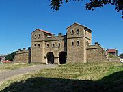
Arbeia Museum
.jpg)

.jpg)
Businesses and Industries
Tyne and Wear is home to many different businesses.
In Gateshead, you'll find Clarke Chapman, an engineering company. The MetroCentre, one of the biggest shopping centers in Europe, is also in Dunston. De La Rue has a large factory at Team Valley that prints banknotes.
Newcastle is home to several well-known companies. Sage Group, which makes accounting software, is based in Hazlerigg. The bakery chain Greggs started here and now has over 1,500 shops. BAE Systems Land & Armaments in Scotswood makes tanks for the British Army, like the Challenger 2. Siemens Energy makes steam turbines in South Heaton. The cleaning product Domestos was first created in Newcastle in 1929.
In North Tyneside, Bellway plc, a housebuilding company, is in Seaton Burn. Cobalt Business Park in Wallsend is one of the UK's largest office parks. Swan Hunter used to build ships in Wallsend and still designs them. Soil Machine Dynamics in Wallsend makes underwater robots, including the world's largest submersible robot, the Ultra Trencher 1.

Sunderland has a very important car factory owned by Nissan Motor Manufacturing UK. It's the largest car factory in the UK. Grundfos, a leading pump maker, also builds pumps in Sunderland. Global Combat Systems makes large ammunition for tanks and artillery here. Many call centers are in Sunderland, including for EDF Energy and Nike UK. The large transport company Arriva also has its main office here.
Other notable businesses include J. Barbour & Sons, which makes outdoor clothing in Simonside, Jarrow. SAFT Batteries makes special batteries in South Shields.
Population Information
This table shows how the population of Tyne and Wear has changed over the years.
| District | Land area | Population | Density (/km2) |
||
|---|---|---|---|---|---|
| (km2) | (%) | People | (%) | ||
| Gateshead | 0% | 202,055 | 18% | ||
| Newcastle upon Tyne | 113.5 | 29% | 302,820 | 27% | |
| North Tyneside | 82.38 | 21% | 207,913 | 18% | |
| South Tyneside | 64.41 | 16% | 150,976 | 13% | |
| Sunderland | 137.4 | 35% | 277,705 | 24% | |
| Tyne and Wear | 398 | 100% | 1,141,469 | 100% | [convert: invalid number] |
Different Backgrounds of People
Tyne and Wear is a diverse place with people from many different backgrounds. This table shows the different ethnic groups living in the area in 1981 and 1991.
| Ethnic Group | Year | |||
|---|---|---|---|---|
| 1981 estimations | 1991 census | |||
| Number | % | Number | % | |
| White: Total | 1,140,786 | 98.8% | 1,109,420 | 98.1% |
| White: British | – | – | – | – |
| White: Irish | – | – | – | – |
| White: Gypsy or Irish Traveller | – | – | – | – |
| White: Roma | – | – | – | – |
| White: Other | – | – | – | – |
| Asian or Asian British: Total | 10,591 | 0.9% | 16,048 | 1.4% |
| Asian or Asian British: Indian | 3,311 | 4,477 | ||
| Asian or Asian British: Pakistani | 2,914 | 4,029 | ||
| Asian or Asian British: Bangladeshi | 1,313 | 2,959 | ||
| Asian or Asian British: Chinese | 1,995 | 2,867 | ||
| Asian or Asian British: Other Asian | 1,058 | 1,716 | ||
| Black or Black British: Total | 1,769 | 2,253 | ||
| Black or Black British: African | 711 | 899 | ||
| Black or Black British: Caribbean | 379 | 478 | ||
| Black or Black British: Other Black | 679 | 876 | ||
| Mixed or British Mixed: Total | – | – | – | – |
| Mixed: White and Black Caribbean | – | – | – | – |
| Mixed: White and Black African | – | – | – | – |
| Mixed: White and Asian | – | – | – | – |
| Mixed: Other Mixed | – | – | – | – |
| Other: Total | 1,956 | 2,679 | ||
| Other: Arab | – | – | – | – |
| Other: Any other ethnic group | – | – | ||
| Non-White: Total | 14,314 | 1.2% | 20,980 | 1.9% |
| Total | 1,155,100 | 100% | 1,130,400 | 100% |
See also
 In Spanish: Tyne y Wear para niños
