Ryhope facts for kids
Quick facts for kids Ryhope |
|
|---|---|
| Population | 10,484 (2011.Ward) |
| Metropolitan borough | |
| Metropolitan county | |
| Region | |
| Country | England |
| Sovereign state | United Kingdom |
| Post town | SUNDERLAND |
| Postcode district | SR2 |
| Dialling code | 0191 |
| Police | Northumbria |
| Fire | Tyne and Wear |
| Ambulance | North East |
| EU Parliament | North East England |
| UK Parliament |
|
Ryhope (pronounced RY-up) is a village located on the coast in North East England. It sits on the southern edge of the City of Sunderland in Tyne and Wear. About 10,484 people lived here in 2011.
Ryhope is close to other towns. It is about 2.9 miles from the center of Sunderland. It is also 2.8 miles from Seaham and 1.2 miles from the main A19.
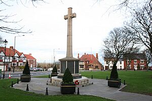
The older part of Ryhope village has a special triangular green. This green features a monument dedicated to war. A newer area, called the 'Colliery' part, is along Ryhope Street. This road leads towards the Tunstall and Silksworth areas of Sunderland.
Contents
Where is Ryhope Located?
Ryhope is a coastal village in Tyne and Wear. A road called the A1018 'Southern Radial Route' goes around Ryhope. This road opened in 2008 and helps traffic reach the Port of Sunderland. It also connects to other parts of Sunderland.
Another road, the B1287 Sea View Road, links Ryhope to the town of Seaham. This town is located to the south of Ryhope.
Farmland surrounds Ryhope, making it feel a bit separate from Sunderland. Many cycle routes pass through the village. Route number 1 is one of these paths. Local volunteers help take care of these routes.
Ryhope is home to the Ryhope Engines Museum. This museum is a popular place to visit.
Ryhope's Past: A Look Back
Ryhope's name comes from old English words. Reof hoppas means "rough valley." The village was first mentioned in history around 930 AD. King Athelstan gave the land of Bishopwearmouth, which included Ryhope, to the Bishop of Chester-le-Street. This land had been taken back from the Vikings.
Farming in Early Ryhope
Ryhope has a long history of farming. In 1183, records show there were 22 villeins. These were farmers who worked the land for a landowner. They provided cattle and crops. By 1380, the village population had grown to about 150 people.
The village's location near the sea made it a popular seaside spot. People have enjoyed bathing at its beach for centuries. It was even a favorite spot for the Bishop of Durham.
The Rise of Coal Mining
Ryhope is located in the Durham coalfield. Like many villages nearby, it changed from farming to coal mining. In 1859, a colliery (coal mine) opened in Ryhope. This brought big changes to the village.
The village grew west towards Tunstall. This created two main parts of Ryhope: the 'Village' and the 'Colliery'. After World War II, a new housing area called 'Hollycarrside' was built.
Railway lines were built to connect Ryhope. They linked the village to Sunderland, Seaham, and other mining villages. Today, only one railway line runs through Ryhope. There is no longer a train station in the village. The coal mine closed in 1966.
The Pit Pony Statue
In 2009, a bronze statue of a pit pony was placed in Ryhope. It was put on a stand at the Stockton Road entrance. This statue was a tribute to the ponies that worked in the mines.
Sadly, the statue was stolen in October 2021. Later, people replaced it with toys and teddy bears. This act became very popular online in 2023.
Ryhope During World War II
In March 1944, Ryhope was part of an important event during World War II. A Handley Page Halifax bomber plane, LK797, crash-landed in Ryhope. This happened after a bombing raid on Nuremberg. The pilot, Cyril Barton, was given the Victoria Cross for his bravery. This award is given for extreme courage.
Sports Teams in Ryhope
Ryhope has two football clubs. They are Ryhope Colliery Welfare and Sunderland Ryhope Community Association. Both teams play in the Northern League.
Famous People from Ryhope
- Mick Buxton was a manager for Sunderland AFC.
- Ronald Radd was an actor.
- Nicola Sturgeon was the First Minister of Scotland. Her grandmother was born in Ryhope.
- Simon Fenton is an actor and writer.
Places to Visit in Ryhope
Ryhope Engines Museum
The Ryhope Engines Museum is a popular attraction. It is based at the Ryhope Pumping Station. This station was built in 1868. Its job was to supply water to the Sunderland area.
Tunstall Hills
Ryhope is next to Tunstall Hills. From these hills, you can see great views of Sunderland. On a clear day, you might even see as far as Whitby. The Tunstall Hills are on the southern edge of Sunderland.
The hills have old quarries and cuttings. These show parts of the Magnesian Limestone. This rock formed during the Permian period. Special plants grow on the slopes of the "Maiden Paps" section. These include blue moor-grass and common rock-rose. You can also find rare plants like Frog Orchid and Autumn Gentian. These areas are protected as a "site of special scientific interest" (SSSI).
Ryhope is also home to a unique structure. It has the world's first (and only) listed Pigeon Cree.
 | Sharif Bey |
 | Hale Woodruff |
 | Richmond Barthé |
 | Purvis Young |


