
Killingworth facts for kids
Quick facts for kids Killingworth |
|
|---|---|

Killingworth
|
|
| Population | 20,079 (Killingworth and Camperdown wards 2011) |
| OS grid reference | NZ2777 |
| Metropolitan borough |
|
| Metropolitan county | |
| Region | |
| Country | England |
| Sovereign state | United Kingdom |
| Post town | NEWCASTLE UPON TYNE |
| Postcode district | NE12 |
| Dialling code | 0191 |
| Police | Northumbria |
| Fire | Tyne and Wear |
| Ambulance | North East |
| EU Parliament | North East England |
| UK Parliament |
|
Killingworth is a town in North Tyneside, Tyne and Wear, England. It is part of the historic county of Northumberland.
This town was built in the 1960s as a "new town." It sits right next to Killingworth Village, which has been around for many centuries. Other nearby villages include Forest Hall and West Moor.
Killingworth has good bus connections to other places in Tyne and Wear. However, it is not on the Tyne and Wear Metro train system. The closest Metro stations are Palmersville and Benton.
Did you know there's another town called Killingworth in Australia? It was named after this British town. This is because both places had many coal mines.
Contents
Culture and Entertainment

Killingworth has been a setting for TV shows and admired for its buildings.
Filming Locations
The town was used for filming the 1973 BBC comedy show Whatever Happened to the Likely Lads?. One of the houses on the Highfields estate was the home of characters Bob and Thelma Ferris.
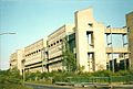
Amazing Architecture
The former British Gas Research Centre in Killingworth was a special building. In a TV show called Grundy's Wonders, presenter John Grundy said it was the best industrial building in the North East of England. It was known for its unique and strong "brutalist" style.
Doctor Who in Killingworth
An episode of Doctor Who called "The Mark of the Rani" showed Killingworth in the 1800s. In the story, the Sixth Doctor was looking for George Stephenson. This was because his enemy, The Master, was trying to mess up the Industrial Revolution. Even though the story was set in Killingworth, the episode was filmed at a museum in Ironbridge.
History of Killingworth
Killingworth has a long history, from medieval times to its modern development.
Early Days
Records show that Killingworth existed as early as 1242. At that time, it was part of the land owned by Roger de Merlay III. In 1296, there were nine people who paid taxes in the area. This number dropped to eight by 1312. By 1373, a survey listed sixteen land holdings in the township.
Common Land and Races
Long ago, a large area of land called Killingworth Moor was kept as common land. It was about 1,800 acres in size. People who owned land in Killingworth and Longbenton could use this common land. From the early 1600s, horse races were held on the moor. Eventually, the races moved to Newcastle Town Moor.
The 1800s Village
In 1841, the village had 112 people living in 14 homes. The village had two rows of cottages along the road. By the mid-1800s, more houses appeared. These were likely built because of the growing coal mines nearby. Today, you can still see some of these old stone buildings.
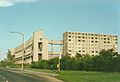
Building a New Town

Construction of the modern Killingworth, a "new town," started in 1963. It was planned to be home for 20,000 people. The town was built on 760 acres of old coal mine land. Northumberland County Council built Killingworth. It was not a "New Town" officially sponsored by the government.
The planners of Killingworth tried new ideas for the town centre. They built tall buildings in a bold and strong "brutalist" style. These buildings won awards for their design and the town's lively feel. The new town centre had concrete houses. Many of these houses had small seashell pieces in their outer walls. There were also tall apartment buildings, offices, and shops. Ramps and walkways connected everything. This made it easy to get around the shops and other places.
Around 1964, a 15-acre lake was created south of the town centre. This happened when old coal mine sites were cleaned up. Today, swans, ducks, and other wildlife live around the two lakes. These lakes are also popular for angling (fishing) and model boating.
Killingworth Colliery and George Stephenson


Killingworth was home to important coal mines, including the famous Killingworth Colliery. This mine was owned by Lord Ravensworth. Many important people worked or trained there. These included George Stephenson, who became a famous locomotive engineer.
George Stephenson's Innovations
In 1814, George Stephenson built his first locomotive, Blücher. He built it in the colliery workshop behind his home, 'Dial Cottage'. This locomotive could pull 30 tons of coal up a hill at 4 miles per hour. It was used to move coal wagons from Killingworth to the Wallsend coal docks. Blücher didn't last long, but it helped Stephenson learn. This knowledge helped him build better locomotives, like the famous Rocket.
Stephenson also worked on a safety lamp for miners. He showed his lamp in the Killingworth pit in 1815. This was just a month before Sir Humphry Davy showed his own design in London. Stephenson's lamp, called the Geordie lamp, was widely used in the North-east.
The railway tracks at Killingworth Colliery were 4 feet 8 inches wide. This was known as the Killingworth tramway or wagonway.
Homes in Killingworth
Killingworth has different types of housing estates.
The Garth Estates
Many of the first houses in Killingworth were built by the local council. The very first ones were at Angus Close. They were for important workers at the British Gas Research Centre. Other estates were called "Garths," like Garth Four or Garth Thirty-Three. In the 1990s, some Garths changed their names to street names. These new names often followed themes like trees or birds.
Many of these houses were made of concrete and had flat roofs. Around 1995, the housing association updated them. They added sloped roofs and made other improvements. Many people who first rented these homes later bought them. Some still live in the houses built in the 1960s.
Private Estates
In the early 1970s, new private housing estates began to be built. One was called Longmeadows. Its streets were named after the Farne Islands. Another estate was Highfields. Its streets were named after famous battles, like Agincourt and Culloden.
The Towers: A Unique Experiment
-
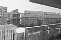
The Towers in the 1970s
-
The Towers just before they were taken down in 1987
-
The Towers again, just before demolition in 1987

.jpg)

One of the most striking parts of Killingworth was "The Towers." These were apartment blocks built in the early 1970s. They were named after castles, like Bamburgh Tower. They had homes built on top of each other, up to 10 storeys high.
Castle-like Design
The Towers were designed to look like a medieval castle. They had an outer wall and an inner keep. Ramps and walkways connected everything. These walkways led to a long, elevated path. This path went straight through the Killingworth Citadel Shopping Centre. This shared design was an experiment, common for that time.
Why They Were Demolished
The idea was to create a strong community. However, the design didn't work as planned. The estate started to feel more like a prison than a castle. There were problems with anti-social behaviour and vandalism. Walkways were used for racing bikes, and rubbish chutes got blocked.
The Towers were never very popular. They were taken down in 1987. The last part, a walkway to the shops, stood alone for 10 years before it was also removed. Now, new private homes stand where The Towers once were.
Town Centre and Shopping
The original town centre was built in the 1960s. The famous boxer Henry Cooper opened the shopping centre. It had a large department store called Woolco.
Shopping Over Time

The very first shops in Killingworth were Moore's and a small sweet shop. These were later taken down. The shopping centre used to have a butcher, a bakery, and a newsagent. The Puffing Billy Pub was built on a bridge over the road. This shopping centre was also demolished in the 1990s.

In the 1980s and 1990s, the Morrisons supermarket complex became the main shopping area. The old Woolco site was empty for over ten years. In the early 2000s, a new, modern shopping mall called Killingworth Centre was built there. Morrisons moved into a new store in this mall. The old Morrisons building is now home to Matalan and Home Bargains.
In 2010, a new KFC restaurant and a pub called 'The Shire Horse' were built next to McDonald's in Killingworth Centre.
White Swan Centre

The White Swan was a large white building in the town centre. It was built in the 1960s and had a lot of office space. It was a very tall building in Killingworth.
Over time, the offices became empty. The building was made shorter and updated. It was then reopened and renamed the White Swan Centre. The name "White Swan" was chosen by local school children. It refers to the swans that live on the local lake. The White Swan Centre now has local services like a doctors' surgery, a library, and a small gym. A new swimming pool and sports centre, called Lakeside, was built next to the lake.
Transport Links
Killingworth has good transport connections. The North East Joint Transport Committee helps manage transport in the area.
Killingworth Bus Station is next to the Killingworth Centre. Buses from companies like Arriva North East and Go North East serve the station. They offer routes to Newcastle upon Tyne, North Tyneside, and Northumberland.
Schools in Killingworth
Killingworth is home to several schools. These include Bailey Green, Grasmere Academy, and Amberley primary schools. The main secondary school is George Stephenson High School. In recent years, Killingworth changed its education system. It moved from having First, Middle, and High schools to a two-tier system.
See also
 In Spanish: Killingworth para niños
