
South Shields facts for kids
Quick facts for kids South Shields |
|
|---|---|
| Town | |
|
|

South Shields
|
|
| Population | 75,337 (2021 census) |
| Demonym | Sandancer |
| OS grid reference | NZ365665 |
| Metropolitan borough |
|
| Metropolitan county | |
| Region | |
| Country | England |
| Sovereign state | United Kingdom |
| Post town | SOUTH SHIELDS |
| Postcode district | NE33, NE34 |
| Dialling code | 0191 |
| Police | Northumbria |
| Fire | Tyne and Wear |
| Ambulance | North East |
| EU Parliament | North East England |
| UK Parliament | |


.jpg)
South Shields (/ʃiːlz/) is a town located on the coast in South Tyneside, Tyne and Wear, England. It sits on the south side of the River Tyne where it meets the sea. Long ago, during Roman times, it was known as Arbeia. Later, in the Early Middle Ages, people called it Caer Urfa. In 2021, about 75,337 people lived there. It is the fourth largest town in Tyne and Wear, after Newcastle upon Tyne, Sunderland and Gateshead.
South Shields is historically part of County Durham. It is located south of North Shields and Tynemouth, which are across the River Tyne. It is also east of Newcastle upon Tyne and Jarrow.
Contents
History of South Shields

People have lived in the area of South Shields since the Late Mesolithic period, which was a very long time ago. The first signs of a settlement in what is now South Shields date back to prehistoric times. Archaeologists have found Stone Age arrowheads and an Iron Age round house at the site of the Arbeia Roman Fort.
The Roman army built a fort here around AD 160. They made it bigger around AD 208. This fort helped supply soldiers along Hadrian's Wall as they fought further north. Soldiers from many places lived at the fort, including bargemen from Persia (modern-day Iraq), infantry from Spain and France, and archers from Syria. The Romans left the fort in the fourth century AD as their empire became weaker. Today, you can still see many ruins, and some parts have been rebuilt as a museum and a popular place to visit.
After the Romans left, the site was used by British settlers. It is believed to have been a royal home for King Osric of Deira. Records show his son Oswin was born in 'Caer Urfa', which is what the fort was called after the Romans. Also, Bede wrote that Oswin gave land to St Hilda to build a monastery here around 647 AD. The current St Hilda's Church, near the Market Place, is thought to be on the same spot as that old monastery.

In the ninth century, Scandinavian people, known as Vikings, raided monasteries and settlements along the coast. They later took over the Anglian Kingdoms of Northumbria, Mercia, and East Anglia. Local stories say a Viking ship crashed at Herd Sands in South Shields while trying to land nearby. Other Viking ships have been found in South Shields and nearby Jarrow.
The modern town of South Shields was started in 1245 and grew as a fishing port. The name "Shields" comes from "Schele" or "Shield," which was a small hut used by fishermen. Another industry that began was making salt by boiling seawater. This grew in the 15th century but caused pollution.
In 1864, a dredger (a boat that clears the riverbed) found a cannon in the River Tyne. More cannonballs have been found in the sands nearby. These items were from the English Civil War. During the war, in 1644, Scottish allies of Parliament captured the town and its Royalist fort. This fort was near the old Roman fort. They also took the town of Newburn. These actions helped them in their siege of Newcastle upon Tyne and helped them control the River Tyne.
In the 19th century, South Shields grew rapidly because of coal mining, chemical production, and glass making. The town's population jumped from 12,000 in 1801 to 75,000 by the 1860s. Many people moved here from Ireland, Scotland, and other parts of England for work. These industries created a lot of wealth for the region and the country.
In 1832, South Shields became a borough and got its own Member of Parliament. This meant taxes were paid to the government instead of the Bishops of Durham. However, the fast growth caused sanitation problems, leading to cholera outbreaks. The Cleadon Water Tower was built in 1860 to help with this problem. In the 1850s, the Tyne Improvement Commission started to improve the river. They made it deeper and built the large North and South Piers to stop silt from building up. Shipbuilding also became a big industry, with John Readhead & Sons Shipyard being the largest.
During World War I, German airships called Zeppelins bombed South Shields in 1916. Later, during World War II, German planes repeatedly attacked the town. This caused huge damage to industries that supported the war and sadly killed many people. A bomb shelter in the market place was hit, and those who died there were remembered with a cobblestone memorial.
Throughout the late 20th century, the coal and shipbuilding industries closed down. This was due to cheaper energy sources and more efficient shipbuilding in other countries. In the 21st century, the town's economy mainly focuses on port activities, ship repair, manufacturing, shops, public services, and a growing tourism industry. New developments like the Haven Centre, Dunes Centre, and the library called The Word show this growth.
Geography


South Shields is on a piece of land that sticks out into the sea, where the River Tyne meets the North Sea. It has six miles of coastline and three miles of riverfront. The huge North and South Piers stand at the mouth of the Tyne. You can get the best view of these from the Lawe Top. Here, you'll also find two replica cannons. The original cannons were captured from the Russians during the Crimean War.
The town gently slopes from the Cleadon Hills down to the river. The Cleadon Hills are easy to spot because of the Victorian Cleadon Water Tower and pumping station. These were opened in 1860 to improve sanitation. There is also a windmill there, which is now old and unused. Both are protected historical buildings and can be seen from far away, even from the sea.
South Shields has wide beaches, sand dunes, and coves. It also has impressive Magnesian Limestone cliffs with grassy areas above them called The Leas. These cover three miles of the coastline and are a protected area managed by the National Trust. Marsden Bay, with its famous Marsden Rock and the historic Grotto pub and restaurant built into the cliffs, is home to one of Britain's largest seabird colonies.
One of the oldest parts of the town is the charming Westoe village. It has a quiet street with beautiful Georgian and Victorian houses. Many of these were built by important business leaders from the coal and shipping industries. This lovely setting, with its parks and trees, was often featured in books by the novelist Catherine Cookson. Westoe village used to be a separate village about a mile from South Shields. However, the town has grown and now surrounds it, along with the village of Harton to the south.
Climate
The climate in South Shields has mild differences between its highest and lowest temperatures. It also gets enough rain throughout the year. This type of climate is known as a "Marine West Coast Climate" or "Oceanic climate".
| Climate data for South Shields | |||||||||||||
|---|---|---|---|---|---|---|---|---|---|---|---|---|---|
| Month | Jan | Feb | Mar | Apr | May | Jun | Jul | Aug | Sep | Oct | Nov | Dec | Year |
| Mean daily maximum °C (°F) | 7 (45) |
8 (46) |
9 (48) |
10 (50) |
13 (55) |
15 (59) |
18 (64) |
18 (64) |
16 (61) |
13 (55) |
9 (48) |
7 (45) |
12 (54) |
| Mean daily minimum °C (°F) | 3 (37) |
3 (37) |
4 (39) |
5 (41) |
8 (46) |
10 (50) |
13 (55) |
13 (55) |
10 (50) |
8 (46) |
5 (41) |
3 (37) |
7 (45) |
| Average precipitation mm (inches) | 33 (1.3) |
33 (1.3) |
30 (1.2) |
43 (1.7) |
48 (1.9) |
43 (1.7) |
38 (1.5) |
48 (1.9) |
48 (1.9) |
53 (2.1) |
53 (2.1) |
51 (2) |
520 (20.6) |
| Source: Weatherbase | |||||||||||||
People of South Shields

Before 1820, South Shields was mostly a quiet countryside area with small villages and farms. There was some shipbuilding, glass making, and salt processing along the river. After 1820, during the Industrial Revolution, South Shields grew into a busy town focused on shipbuilding and coal mining. Many people moved here from other parts of the River Tyne, rural County Durham, Northumberland, Scotland, and Ireland. Most people living in South Shields today are descendants of those who moved there for work during this time.
Towards the end of the 19th century, the British Navy needed sailors. This led to Yemeni British sailors settling in the town, starting the first Yemeni community there.
| South Shields | South Tyneside | |
|---|---|---|
| White British | 93.3% | 95.0% |
| Asian | 3.2% | 2.2% |
| Black | 0.4% | 0.3% |
In South Shields, about 6.7% of the people are from an ethnic minority group (not White British). This is higher than the 5.0% in the wider South Tyneside area. Most of the Asian people in South Shields are Bangladeshi. In the Beacon and Bents area, which covers the town centre, 9.9% of the population is Bangladeshi. The Bangladeshi community here is the third largest in Tyne and Wear, after Newcastle upon Tyne and Sunderland. Nearly all of the ethnic minority population in South Tyneside lives in South Shields town centre and nearby areas like Rekendyke and Westoe.
Yemeni community
South Shields has had a Yemeni British community since the 1890s. Many Yemenis came to work as seamen on British merchant ships, especially as firemen in the engine rooms. Similar communities also grew in Hull, Liverpool, and Cardiff. In 1909, the first Arab Seamen's Boarding House opened in the Holborn riverside area of the town.
During World War I, there was a shortage of ship crews. Many Yemenis were hired to work on British ships at the port of Aden, which was then a British protectorate. By the end of the war, the Yemeni population in South Shields had grown to over 3,000. South Shields lost a large number of Merchant Navy sailors, and about one in four of them were of Yemeni background. The port in South Shields employed people from Yemen, Aden, Somalia, Africa, India, and Malaysia.
Sometimes, there were disagreements over jobs, which led to difficult times in 1919 and 1930. However, over time, people's attitudes towards Yemenis in the town improved, and such problems did not happen again in a big way.
After World War II, the Yemeni population decreased. Some moved to other industrial cities like Birmingham, Liverpool, and Sheffield. But the main reason was the decline of the shipping industry and the reduced need for sailors as coal-burning ships became less common. Today, about 1,000 Yemenis live in South Shields. Many Yemeni sailors married local women and became a part of the wider community. The Yemeni people were one of the first settled Muslim communities in Britain.
There is a mosque at Laygate, which also includes the Yemeni School. The famous American boxer Muhammad Ali visited this mosque in 1977. He had his marriage blessed at the Al-Azhar Mosque, which is one of the earliest mosques in the UK. This story is told in a film called The King of South Shields. In 2008, an exhibition about the Yemeni community in South Shields was held at the BALTIC Arts Centre in Gateshead. It showed how the Yemeni story is an example of early successful multicultural integration in Britain. It also highlighted Muhammad Ali's visit.
Bangladeshi community
The Bangladeshi community in South Shields is actually larger than the Yemeni community, though the Yemenis have been there for much longer. The Bangladeshi community is the third largest in the North East of England.
In 2008, the Bangladesh Welfare Association opened in South Shields to support the community.
Economy

The last shipbuilding company, John Readhead & Sons, closed in 1984. The last coal mine, Westoe Colliery, closed in 1993. Today, the town mainly relies on service industries, like shops and offices. Many people who live in South Shields travel to work in nearby Newcastle, Gateshead, North Tyneside, and Sunderland.
For many years, South Tyneside had one of the highest unemployment rates in mainland Britain. However, between 2002 and 2008, unemployment in South Shields fell by 17.8%. This was the best improvement in the North East region during that time.
The Port of Tyne is one of the UK's most important ports. It is growing its activities for carrying goods and passengers. In 2007, it imported two million tonnes of coal. Manufacturing and ship repair are also important industries.
South Shields has received a lot of money for improvements from both public and private sources. Recently, this has focused on the town centre, riverside, and foreshore areas. This is because the old heavy industries have declined, and the town is becoming more important as a business and tourist destination.
Tourism

The town is a popular seaside resort with many famous places and things to do. Tourism is a big part of the town's economy. To attract visitors, South Shields has many cycle paths and walking trails, a promenade, parks and gardens, fairground rides, arcades, crazy golf, laser tag, a miniature steam railway, a boating lake, a ten-pin bowling centre, and an amphitheatre.
Leisure and entertainment
South Shields offers a good choice of restaurants, cafes, pubs, and nightlife. There are also hotels, guest houses, and caravan parks in and around the town.
South Shields hosts a free summer festival every year. Each autumn, the town is the finish line for the Great North Run, a famous half marathon. It also has public gala shows at the Customs House. During the week of the Great North Run, there is a Magic Convention with lectures and shows by top magicians from around the world.
Landmarks
A famous landmark in South Shields is the rebuilt Roman fort and the old Arbeia Roman Castra (military camp). This fort is part of the Hadrian's Wall World Heritage Site. South Shields is also home to the oldest local newspaper in the UK, the Shields Gazette.
The town's museum and art gallery has a special exhibition about the life of Catherine Cookson. From 1985 to 2009, the area was even called "Catherine Cookson Country" to attract visitors.

There are several landmarks related to trade and industry. These include the headquarters, warehouse, and factory of the fashion company Barbour. The Customs House is a theatre and arts venue. The historic Mill Dam is a riverside area. The town has traditional, continental, and farmers' markets, as well as a main street with shops.
Natural landmarks include The Leas cliff tops and Haven Point, as well as the bays of Littlehaven, Sandhaven, and Marsden.

Important buildings in and around the town include:
- St Hilda's Church, believed to be built where Hilda had a chapel in the seventh century.
- The combined Jubilee Clocktower and Wouldhave Memorial. This stands on Pier Parade next to "Tyne," Britain's second-oldest preserved lifeboat.
- The National Trust-owned Souter Lighthouse.
Lighthouses and Piers
 |
|
| Location | South Shields |
|---|---|
| Coordinates | 55°00′40″N 1°24′04″W / 55.011208°N 1.400980°W |
| Year first lit | 1895 |
| Construction | stone tower |
| Tower shape | tapered cylindrical tower with balcony and lantern |
| Markings / pattern | unpainted tower, white half lantern, red half lantern |
| Height | 12 metres (39 ft) |
| Focal height | 15 metres (49 ft) |
| Range | white: 13 nmi (24 km; 15 mi) red: 9 nmi (17 km; 10 mi) green: 8 nmi (15 km; 9.2 mi) |
| Characteristic | Oc WRG 10s. |
| Fog signal | bell every 10s |
| Coordinates | 55°00′29″N 1°25′27″W / 55.008021°N 1.424082°W |
|---|---|
| Year first constructed | 1882 |
| Construction | metal skeletal tower |
| Tower shape | hexagonal frustum skeletal tower with observation room, balcony and lantern |
| Markings / pattern | red tower and lantern |
| Height | 15 metres (49 ft) |
| Focal height | 15 metres (49 ft) |
| Range | white: 19 nmi (35 km; 22 mi) red and green: 11 nmi (20 km; 13 mi) |
| Characteristic | Oc WRG 10s. |
| Fog signal | bell every 5s. |
Work on the North and South Tyne Piers began in 1854. They were built by the new Tyne Improvement Commission to protect ships entering and leaving the river. The main architect was James Walker. Building was delayed by storm damage in 1862. The South Pier was finished in 1895, and its lighthouse started working that same year. This lighthouse shows different colored lights to guide ships. White light means safe waters, green means safe waters near the coast to the north, and red means an area with many shipwrecks to the east and south. The pier is 5,150 feet long and is open to the public when the weather is good.
The North Pier (at Tynemouth) and its lighthouse were meant to be similar to South Shields'. However, problems and collapses meant the North Pier was finished much later and with a different design. In 1908, the South Pier Lighthouse got a bell that rang every thirty seconds in foggy weather.
There is a third lighthouse, just upriver from the pier, on the Herd Groyne at South Shields. This groyne was built between 1861 and 1867 to protect Littlehaven Beach. This unusual lighthouse was built in 1882. It has an upper hexagonal part (with the light) made of wood and metal, sitting on twelve steel legs. The whole structure is painted red and is 49 feet tall. The Groyne lighthouse also shows different colored lights. White light means a ship is on the correct path, green means it's off course to the north, and red means it's off course to the south.
In 1928, both the South Pier and the Groyne lights were changed from gas to automatic electric power. They were powered by mains electricity, with gas lights kept as a backup. In 1961, a new system allowed the fog bells to be turned on and off by keepers in the Tynemouth Pier lighthouse using an infrared beam across the river. This was later replaced by a radio link to an automatic fog detector. In 1999, the white light of the South Pier was made stronger, making the old High and Low Lights of North Shields no longer needed. The Herd Groyne lighthouse was updated and repainted in 2014 and still helps guide ships. In 2015, the fog bells on both lighthouses were no longer used.
Town Halls
A very important building in the town is South Shields Town Hall, built between 1905 and 1910. It's a grand building that shows the town's wealth during the Edwardian era. The architect was E. E. Fetch. The building has many decorations that refer to the town's sea history. For example, there are sculptures of Britannia and other figures, a figure of Mercury on top of the Council chamber's dome, and fountains in the front. The 145-foot clock tower has a clock that chimes and five bells. On top of the tower is a weather vane shaped like a galleon (an old sailing ship).
The Old Town Hall, a square building from 1768, is the main feature of the Market Place. It stands at the end of King Street. The ground floor is open with arches on each side. The top floor has a sloped roof and a wooden bell tower. It was originally built and used by the Dean and Chapter of Durham and was sold to the town in 1855.
Education
South Shields is home to South Tyneside College. This is one of the two main places in the UK for training people to work at sea. It has special facilities like a marine safety training centre and a fake ship's bridge to train officers. The college also used to have the only planetarium and an observatory in the region. These were popular places for local schools and visitors. The observatory was used for 20 years but was no longer needed after 2008. The room that held the planetarium is now a mosque. The college offers many other courses and training programs.
Local schools are generally considered very good. This is shown by improving school results and positive inspections.
In 2007, Brinkburn Comprehensive and King George V Comprehensive schools joined together to form South Shields Community School. The new school was built for £19 million on the King George V School site and opened in September 2011. However, this school closed in 2020.
St Mary's C of E Primary School was a Christian school for children aged 3–11. It was founded in 1867 to educate children from working-class families, following the principles of the church it was connected to. This school closed in July 2008. The building was taken down in late 2016.
Regional Identity

People born in South Shields are often called Geordies. This term is commonly used for all people who live in Tyneside.
A less common local nickname is Sandancer. This name probably comes from the town's beach and its history.
Notable People

Many famous people have connections to South Shields. They include:
- Angelic Upstarts - a punk band that started in South Shields in 1977.
- Michael Algar, also known as Olga – guitarist and singer for the band The Toy Dolls.
- Kane Avellano – a long-distance motorcycle rider who holds a Guinness World Record for being the youngest person to ride a motorcycle around the world alone (at age 23 in 2017).
- Catherine Cookson – a famous author.
- Josef Craig – a paralympic swimmer who won a gold medal at the 2012 Summer Paralympics.
- Perrie Edwards and Jade Thirlwall - singers and members of the successful girl group Little Mix. Jade Thirlwall is from the Yemeni community in Laygate.
- Eric Idle – a comedian, actor, and songwriter, famous for being part of Monty Python.
- John Simpson Kirkpatrick – a war hero from World War I.
- Joe McElderry – a singer who won The X Factor.
- Sarah Millican – a comedian.
- Ridley Scott − a famous film director.
- Demi Stokes - a footballer who won the 2022 Women's Euros with the Lionesses.
- William Wouldhave – the person who created the lifeboat.
Sport
Football
South Shields F.C. is the town's main football team. The club was formed in the early 1900s and played in the Football League in the 1920s. The team became famous recently for winning the FA Vase in 2017. They currently play in the National League North, which is the sixth level of English Football, after being promoted in 2023. They also have a women's team that plays in the fifth level of women's football.
Rugby
South Shields has two rugby union clubs: South Shields RFC and Westoe RFC.
South Shields RFC started in 1956 and plays at Grosvenor Road. They are currently in the Durham & Northumberland 3rd Division.
Westoe RFC (now called South Shields Westoe) was formed in 1875 and still plays at its original ground, Wood Terrace. In 2005, they reached the final of the Intermediate Cup at Twickenham but lost. They rose to the fourth level, National League Two, and now play in the Durham & Northumberland 1st Division.
Transport
South Shields is connected by the A19 road to the west and is close to the Tyne Tunnel at Jarrow. The town has good connections to other areas of Tyne & Wear and to major roads. The A194(M) motorway links the town directly to the A1/A1(M).

The Tyne and Wear Metro is a light rail system that started in the 1980s. It replaced older train services. The Metro connects South Tyneside, Gateshead, Newcastle, North Tyneside, Sunderland, and Newcastle Airport. The platform at the former South Shields Metro station is on a bridge right above King Street, the town's main shopping area.
The new combined bus and Metro station opened on August 4, 2019, on Keppel Street. This is across the road from the old Metro station at King Street.

There is a regular ferry service for people to North Shields on the other side of the Tyne. The Shields Ferry carries many thousands of people each year. There has been a ferry service across the river between the two towns since 1377.
The Port of Tyne headquarters and international freight terminal are located at Tyne Dock in South Shields. The Port also has a train connection for goods.
Local bus routes are run by Stagecoach North East and Go North East. These are planned to connect well with Metro services.
There is a National Express coach service that goes directly to London.
The town has many footpaths and cycle routes, including the Sea to Sea Cycle Route and National Cycle Route 1.
Images for kids
-
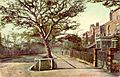
Westoe village in 1904
-
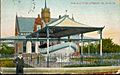
The retired 'Tyne' life boat in 1904; a tribute to all crewmen who served on her
-
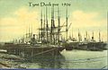
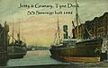
River Tyne Docks in 1906
-
Tyne Docks in 1902
-
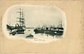
Tyne Docks in 1886
-
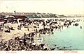
Sands at South Shields in 1903
-
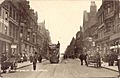
King Street in 1905
-
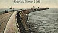
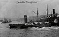
South Shields Pier in 1904
-
Early 1900s Tyne Ferry Boat
-
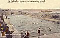
South Shields once had an open-air swimming pool
-
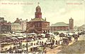
Market Place in 1904
-
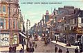
King Street in 1906
-
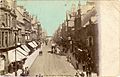
King Street in 1904
-
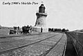
Early 20th century South Shields Pier


See also
 In Spanish: South Shields para niños
