
Cleadon facts for kids
Quick facts for kids Cleadon |
|
|---|---|
 Houses on Front Street near the centre of Cleadon, to the north of the village pond. |
|

Cleadon
|
|
| Population | 8,427 |
| OS grid reference | NZ384624 |
| Metropolitan borough |
|
| Metropolitan county | |
| Region | |
| Country | England |
| Sovereign state | United Kingdom |
| Post town | SUNDERLAND |
| Postcode district | SR6 |
| Dialling code | 0191 |
| Police | Northumbria |
| Fire | Tyne and Wear |
| Ambulance | North East |
| EU Parliament | North East England |
| UK Parliament |
|
Cleadon is a village in South Tyneside in the North East of England. Before 1974, it was part of County Durham. In 2011, about 8,427 people lived in the Cleadon and East Boldon area.
The village is close to East Boldon, Whitburn, and Jarrow. It's about 5 miles (8 km) from Sunderland and South Shields. Cleadon is located near Cleadon Hills, which is a special grassland area with rare plants.
For a long time, Cleadon was mostly about farming. Now, many people live here and travel to work in other towns. The village has two churches, a primary school, and shops and pubs.
Contents
History of Cleadon Village
The oldest signs of people living near Cleadon go back to the Mesolithic period (8,000-4,500 BC). Even though we haven't found direct proof in Cleadon itself, tools made of flint have been found nearby. This suggests that hunting groups passed through the area. Farmers from the Neolithic period (4,500-2,400 BC) also likely lived in Cleadon. We know this from more flint discoveries, but we don't know exactly where their homes were.
Cleadon in the Middle Ages
Cleadon was first written down as Clyuedon in a book called the Boldon Book in 1183. It was listed with Whiteberne, which is now Whitburn. The name Clyduedon means "hill of the cliffs" in Old English. This name probably describes the hills around the village.
Cleadon didn't have big rivers for water. Instead, it got water from springs and wells. A village pond, which is still there today, helped people live in the area for many centuries.

The Boldon Book also talked about land ownership and rules for Cleadon and Whitburn. This shows that a system for managing the area was already in place by 1183. The book also mentioned a "pound" or "pinfold." This was a place where stray animals were kept until their owners claimed them. Today, a plaque marks where the pinfold used to be. It says that the person who looked after the animals, called the Pinder, was important and had 12 acres of land.
In the 12th century, about 172 people lived in Cleadon. Later, in the 1300s, a new survey was done by Thomas Hatfield, who was the Bishop of Durham. This survey also looked at Cleadon and Whitburn together. Between the 12th and 14th centuries, the area faced big challenges. The Black Death (a terrible sickness) spread, and there were threats from Scotland during the Wars of Scottish Independence. For example, Robert the Bruce raided Hartlepool in 1312. The weather also changed a lot during the Little Ice Age, causing widespread hunger.
Early Modern Cleadon
The first time Cleadon appeared on a map was in 1576. It was called Cleydon and shown as just one building. In 1644, during the English Civil War, Cleadon was caught between two sides: the Royalists from Newcastle and the Parliamentarians from Sunderland. This led to a battle nearby called the Battle of Boldon Hill. It's thought that Briar Cottage in Cleadon might have been used as a hospital during the war.
By the end of the 1600s, a system called enclosure became common in County Durham. This meant that smaller pieces of land were combined into bigger, easier-to-manage fields. The Cleadon enclosure agreement happened in April 1676. Farms became very important in the village, helped by the pond and good pastures.
More detailed maps of Cleadon were made in the late 1700s. A map from 1754 showed Cleadon Mill and some of the main landowners.
Cleadon in the 18th and 19th Centuries
During the 1700s and 1800s, large fancy houses with beautiful gardens were built in and around Cleadon. These houses likely provided many jobs for local people. One example that still stands today is Cleadon House. It was built in 1738 by John Dagnia, a famous glass maker. Cleadon House was built using a newer style for the time.

A blue plaque outside Cleadon House tells us that John Dagnia lived there. He was known for making a special type of glass called lead crystal, which was very high quality. This glass was made in South Shields.
Cleadon House also had a huge 15-acre garden with lawns, a fruit wall, a lake, and a grotto (a small cave-like structure). Today, only a small part of the original garden remains. You can still see a section of the old wall, signs of water features, and the grotto in Coulthard Park. The grotto is a Grade II listed building, meaning it's an important historic structure.
Another big house built in Cleadon in the 1700s was Cleadon Old Hall. It also had gardens and a pond. This house was knocked down in the 1960s, but old photos show it was a grand building from the Georgian era.

In the 1800s, Cleadon was still part of the larger Whitburn area. The number of people living there grew a lot, from 675 in 1801 to 3,292 in 1901. A report from that time said Cleadon had "a small Methodist chapel, four farmholds, two public houses, and a ladies' boarding school." Cleadon Parochial School opened in 1830 and later became Cleadon Church School in 1872.
In 1891, Walter Scott wrote about Cleadon. He described Cleadon House as "a quaint, picturesque residence." He also said that "Cleadon does not materially differ from the ordinary country village." He mentioned Cleadon Towers (built in 1890), the village's three pubs, the village green, the pond, the church, and the school.
Even though farming was still important, making bricks and tiles, and quarrying limestone became big industries in Cleadon during the 1800s. In 1855, there was one brickworks. By the end of the century, there were four, showing how much demand there was for bricks. Today, the old clay pits from the brickworks are now flooded and form the Tilesheds Local Nature Reserve, which opened in 1997.
Cleadon in Modern Times
In the late 1800s and early 1900s, wealthy people started moving to Cleadon. This led to the building of the Cleadon Plantation residential area. Cleadon was a good distance from the crowded city centers. By the end of the 1800s, many different types of workers lived in the village, including a nurse, a lawyer, a violin-string maker, and many laborers.
The first train station in the area, Cleadon Lane Station, opened in the 1800s. It was renamed East Boldon Station in 1898 and is still used today as East Boldon Metro station.

A big change to the village happened when the first housing estate was built in the 1900s. This was the Cleadon Plantation Housing Estate. It had large houses for wealthy people like surgeons and managers.
In 1903, the village school moved to a new building, now called The Old Schoolroom. In 1908, the Cleadon National School opened for children aged 7 to 13. Another new building for younger children opened in 1909 but closed in 1962.
Cleadon played an important part during the First World War. It was a good place to train soldiers because it was between Sunderland and the River Tyne. It also helped with coastal defense. Cleadon Hill Farm was used as a landing spot for planes from April 1916 to December 1917. Cleadon was not bombed by enemies during the First World War. However, a shell from a friendly gun hit Briar Cottage by accident. A document from 1918 shows that soldiers stayed in Cleadon Meadow, a camp at Cottage Homes, and Wesley Hall. You can still see practice trenches (zigzag patterns in the ground) on Cleadon Hills today. The Cleadon War Memorial was put up in November 1920 to remember the 22 men from Cleadon who died in the war. After the war, more houses were built, and new bus services made it easier to travel to South Shields.

Cleadon was at risk during the Second World War because it was close to the River Tyne and River Wear. Defenses were built along the east coast of England starting in 1938. These included pillboxes (small concrete bunkers), gun positions, and minefields. A big anti-aircraft gun battery was in Cleadon from 1940 to 1946. A searchlight battery was also there. The Ship Inn pub was the local home guard's headquarters. On August 15, 1940, German bombers aimed for shipyards but dropped bombs in Cleadon. No one was killed or badly hurt. Cleadon was hit by more bombs from 1940 to 1943, and some people did die in those attacks.
The village grew quickly after the war. New houses were built on Laburnum Grove and south of Whitburn Road. Cleadon Park Estate also got bigger when the council bought the grounds of Cleadon Park House and opened them as Cleadon Park. Digging for sand and gravel in the grounds of Cleadon House destroyed many of the old gardens. The pleasure grounds were bought by the council and are now Coulthard Park.
Some old cottages and houses in the village were knocked down in the 1960s and 70s, which caused some disagreement. Three large houses – Cleadon Park, Cleadon Meadows, and Cleadon Old Hall – were demolished. To make way for changes to Sunderland Road and Shields Road, the Ship Inn pub was destroyed, and the village pond was made smaller. In 1963, a new Junior School opened on Boldon Lane. In 1975, the central part of Cleadon was named a Conservation Area because of its old layout. This area was made larger in 2004 to include the Cleadon Plantation residential area.
Cleadon Hills: Nature and History
<mapframe text="Outline of Cleadon Hills Local Nature Reserve" width="220" height="220" zoom="13" longitude="-1.39466" latitude="54.96158" align="right"> { "type": "FeatureCollection", "generator": "overpass-ide", "copyright": "The data included in this document is from www.openstreetmap.org. The data is made available under ODbL.", "timestamp": "2021-12-28T13:14:24Z", "features": [ { "type": "Feature", "properties": { "@id": "relation/10283697", "boundary": "protected_area", "designation": "local_nature_reserve", "leisure": "nature_reserve", "name": "Cleadon Hills Local Nature Reserve", "protect_class": "7", "tourism": "yes", "type": "multipolygon" }, "geometry": { "type": "Polygon", "coordinates": [ [ [ -1.3968092, 54.9611475 ], [ -1.3967687, 54.96104 ], [ -1.3964576, 54.9612064 ], [ -1.3962844, 54.9612206 ], [ -1.3961486, 54.961215 ], [ -1.3948537, 54.9600697 ], [ -1.3935998, 54.9589608 ], [ -1.3910625, 54.9600832 ], [ -1.3910141, 54.9601054 ], [ -1.3909956, 54.9601138 ], [ -1.3907807, 54.9602057 ], [ -1.3906435, 54.960227 ], [ -1.3906497, 54.9602655 ], [ -1.3906591, 54.9602827 ], [ -1.3911063, 54.961152 ], [ -1.3925841, 54.9609256 ], [ -1.3929704, 54.9613414 ], [ -1.39348, 54.9621052 ], [ -1.3930362, 54.9623835 ], [ -1.3938218, 54.9625494 ], [ -1.3954265, 54.9635563 ], [ -1.3954764, 54.9635558 ], [ -1.3961801, 54.9635481 ], [ -1.3966021, 54.9635435 ], [ -1.3965883, 54.9631605 ], [ -1.3968945, 54.9631588 ], [ -1.3971562, 54.9631574 ], [ -1.3971655, 54.9629718 ], [ -1.3972093, 54.9622507 ], [ -1.3972119, 54.9622148 ], [ -1.3972317, 54.961937 ], [ -1.397154, 54.9617056 ], [ -1.3969171, 54.9614195 ], [ -1.3968496, 54.9612507 ], [ -1.3968232, 54.9611847 ], [ -1.3968092, 54.9611475 ] ] ] }, "id": "relation/10283697" } ] } </mapframe> Cleadon Hills Local Nature Reserve is to the north-east of the village. It's a very important example of a special type of grassland called Magnesian limestone grassland. It's also a Site of Special Scientific Interest, which means it's protected for its nature. You can find wildflowers like cowslips, wild thyme, and autumn gentian growing there. These plants can grow because of the shallow limestone soil.
The limestone landscape was formed millions of years ago (290 to 248 million years ago!). It was made from sediments that built up at the bottom of an ancient sea called the Zechstein Sea. This limestone was used to build walls, including the ones around Cleadon Hills. You can still see some of the smaller quarries and cliffs today. The village of Cleadon is located on the south-west side of Cleadon Hills.
Cleadon Windmill

The old windmill on the Hills is a Grade II listed building, meaning it's historically important. There has been a mill here since at least the 1600s. The building you see today was first built in the 1820s and then rebuilt after a storm in 1842.
The mill was used to grind grain. Different people ran the mill over the years, like Joseph Watson in 1828 and the Gibbons family in the 1850s. The mill stopped working in the late 1800s. It was also damaged during the First World War when it was used for gun practice. Today, the mill no longer has its top or sails, but the stone tower is still standing.
A local legend says the mill is haunted by the ghost of the miller's daughter, Elizabeth Gibbons, who died of a broken heart.
Cleadon Water Tower
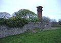
Also on Cleadon Hills is an old water pumping station. It used to provide water to the South Shields area. The most noticeable part of the site is the Cleadon Water Tower. This tall chimney (also called a campanile) was for the old steam-powered pumps. You can see it from miles around, and it's also a Grade II listed building.
Cleadon Pumping Station was built between 1859 and 1862. It was one of several pumping stations that used the clean fresh water found in the limestone. By 1860, the Cleadon station was pumping over a million gallons of water a day! By 1862, it was the biggest of its kind.
The chimney has a balcony 82 feet (25 meters) above the ground. A spiral staircase with 141 steps winds around the inside. The pumping station closed in the 1970s after the Derwent Reservoir opened. The other buildings have been turned into homes, but the tall chimney remains. During the Second World War, the Water Tower was used as a landmark for navigation, like Souter Lighthouse.
Wartime Defences on Cleadon Hills
You might find a rare pillbox (a small concrete bunker) from the First World War on Cleadon Hills. Two pillboxes were also built here during the Second World War. These were machine gun positions that looked out over the fields. Only one of these remains today, mostly hidden by plants.
Life in Cleadon Today
In 2011, the Cleadon and East Boldon area had 8,457 residents. Most people (96%) were white, and 96.3% were born in the UK. English was the main language for almost everyone (98.2%). The largest religious group was Christianity (75.8%). Most residents (57.1%) had jobs, often in shops, health, or social work. The most common type of job was 'Professional'.
How Cleadon is Governed
In the UK national parliament, Cleadon is part of the Jarrow area. The Member of Parliament (MP) for Jarrow is Kate Osborne from the Labour Party. She has been the MP since 2019. An MP is a person elected to represent their local area in the House of Commons, where laws are made for the whole country.
For local matters, Cleadon is part of the Cleadon and East Boldon ward in South Tyneside Council. A ward is a local area that elects councillors to represent it. These councillors help make decisions about local services like schools, parks, and roads. This ward is represented by Conservative Councillors Ian Forster and Stan Wildhirt, and Joan Atkinson from the Labour Party.
Things to Do in Cleadon
Shops and Pubs
Cleadon's main shopping area is along Front Street. You can find gift shops, antique shops, fashion stores, hairdressers, a One Stop shop, a pharmacy, and cafes.
There are three pubs in Cleadon:
- The Britannia Inn: This pub is on Front Street and was built in 1894. Inside, you can still see a stone fireplace from an old house that stood there, dated 1675.
- The Cottage Tavern: This pub is on North Street and was built in the late 1800s.
- The Stables: This microbrewery (a small place that makes its own beer) opened in April 2021 on Front Street.
Coulthard Park
Coulthard Park is in the center of Cleadon. It used to be the gardens of Cleadon House. Today, it has a bowling green, a play area for kids, tennis courts, and a pavilion. Some large trees, mostly chestnut trees, and the 18th-century grotto from the old gardens are still there. A blue plaque in the park explains that the grotto is an 18th-century garden decoration.
Cleadon Church of England Academy
Cleadon Church of England Academy is the village's primary school. The Infant and Junior Schools joined together in the early 2000s. A new school building was finished in 2007. The school became an academy in 2014, and a nursery was added in 2017.
In 2011, the school was rated 'outstanding' by Ofsted (the organization that inspects schools in England). In 2019, 74% of students met the expected standards in reading, writing, and math at the end of Key Stage 2 (around age 11). This was better than the average for the local area and England.
Churches in Cleadon
- All Saints Church: This is a C of E church on Sunderland Road. Before it was built, people from Cleadon had to go to church in Whitburn. Villagers wanted a closer church, so permission was given, and it was finished in 1869. The church has beautiful windows that show miracles of Jesus and a War Memorial window.
- Cleadon Methodist Church: This church is also on Sunderland Road. Before the church was built, Methodist services were held in a farm cottage owned by John Burdon. John Burdon was a friend of John Wesley, who founded Methodism and visited Cleadon in 1743. Villagers wanted their own Methodist church, and the foundation stone was laid in 1899.
Transport in Cleadon
Cleadon is located on the A1018 road, which connects South Shields and Sunderland. The village is also close to East Boldon Metro station, which is part of the local train system. Bus services from Go North East and Stagecoach North East also serve the village.
Famous People from Cleadon
- Don Revie: A famous footballer and manager who lived in Cleadon.
- Carlo Little: A rock and roll drummer who died in Cleadon.
- Paul Darling: A lawyer who grew up in Cleadon.
- Bill Travers: An actor and animal rights activist who was born in Cleadon.
- Simon Brown: A cricketer who was born in Cleadon.
Images for kids
-
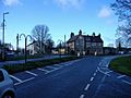
Crossroads in the centre of Cleadon looking towards the Toby Inn Carvery.
-
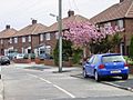
Residential area near Tilesheds Lane.
-
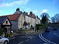
Houses on Front Street near the centre of Cleadon, to the north of the village pond.
-
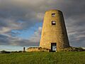
Cleadon Windmill.
-
Cleadon Water Tower - the surviving chimney (or campanile) of the old pumping station.
-
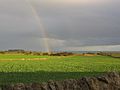
Looking East from Cleadon Hills.
-
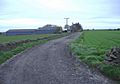
Cleadon Hills Farm.
-
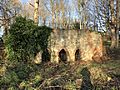
The 18th century grotto in Coutlhard Park.
-
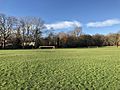
View of the football goalposts in Coulthard Park.
-
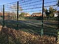
Tennis courts in Coulthard Park.


