
Whitburn, Tyne and Wear facts for kids
Quick facts for kids Whitburn |
|
|---|---|
| Village | |
 Houses on Front Street, Whitburn |
|

Whitburn
|
|
| Population | 7,448 |
| OS grid reference | NZ 40798 61943 |
| Metropolitan borough |
|
| Metropolitan county | |
| Region | |
| Country | England |
| Sovereign state | United Kingdom |
| Post town | SUNDERLAND |
| Postcode district | SR6 |
| Dialling code | 0191 |
| Police | Northumbria |
| Fire | Tyne and Wear |
| Ambulance | North East |
| EU Parliament | North East England |
| UK Parliament | |
Whitburn is a charming village located on the coast of North East England. It's part of South Tyneside in the area of Tyne and Wear. The village is about 3 miles (5 km) north of Sunderland and 4 miles (6 km) south of South Shields. Long ago, Whitburn was part of County Durham.
Whitburn sits on a gentle slope that looks out over Sunderland. For many years, it was a place where people fished and farmed. Today, it has schools, churches, a cricket club, parks, shops, and a pub. In 2011, about 7,448 people lived in the Whitburn and Marsden area.
Contents
What's in a Name?
The name Whitburn first appeared in a very old book from 1183 called the Boldon Book. It was written as Whitberne.
This name might come from a stream or "burn" that flows through the village. Another idea is that it means "Hwita's burial mound," where a Saxon nobleman named Hwita was buried. It could also mean "white barn" in Old English.
A Look Back in Time: Whitburn's History
People have lived in Whitburn for a very long time! The oldest signs of human life here go back to the Mesolithic period (around 8,000–4,500 BC). Scientists have found burnt clay from old wooden buildings near the coast. Tools from the Stone Age and Bronze Age have also been found. In 1929, a Bronze Age burial site was discovered at Wheatall Farm. It held the remains of a 35-year-old person buried with an arrowhead and other items.
When the church in Monkwearmouth was started in 674, the king gave all the royal lands in this area, including Whitburn, to the Church. Whitburn was in an important area for learning and culture during this time. It was located between the famous monasteries of Jarrow and Monkwearmouth.
Medieval Village Life
A part of the village is known as an important archaeological site because it was once a medieval village. During the Middle Ages, Whitburn was a small community with its own church and hall. By the 1100s, Whitburn was a "two-row green village." This means houses were built in two lines facing a long, open grassy area.
Whitburn had a large stone building called a tithe barn. This barn was part of the old feudal system where farmers gave a part of their crops to the church or lord. The original tithe barn was destroyed by a bomb in World War II.
The Whitburn Parish Church was built in the 1200s, and Whitburn Hall was built in the 1500s. These buildings became the main spots in the village.
The Boldon Book from 1183 also mentions Whitburn and a person named "John of Whitburn." This shows that the village was already well-known back then.
Growing and Changing
For a long time, until the mid-1800s, Whitburn was mostly a farming and fishing village. But as industries grew in the 1800s, more people moved to Whitburn. Its population grew from 675 people in 1801 to 2,738 in 1891.
In 1857, people described the village as having a church, a post office, a brewery, and three pubs. Wealthy business owners, coal miners, and fishermen all lived in Whitburn. New houses, two schools, and a new Methodist Church were built.
Whitburn Colliery (a coal mine) opened in the 1840s. This helped the local brick and iron businesses and met the growing need for coal. The mine closed in 1968.
Whitburn in Wartime

During World War I, Whitburn had defenses along its coast. Soldiers were stationed here to protect the area. In 1921, a war memorial was put up on the village green to remember those who died.
In World War II, the coast of Whitburn was often attacked by German planes. A German bomber even crashed into the sea here in 1940, but the airmen survived. Some cottages in Whitburn Bents were also badly damaged by bombs.
A special "bombing decoy" was built near Whitburn. It was designed to look like a city on fire to trick enemy bombers away from important places like the Tyne and Sunderland docks. The old Whitburn windmill was used as a lookout post to watch for enemies at sea.
After the wars, many new homes were built in Whitburn. The village became a place where people lived but traveled to other towns for work.
A Famous Visitor
Did you know that Lewis Carroll, the author of Alice's Adventures in Wonderland, visited Whitburn? He stayed with his cousin here. Many people believe he wrote the famous poem The Walrus and the Carpenter while he was on holiday in Whitburn!
Who Lives in Whitburn?
| Whitburn and Marsden Ward compared (2011) | |||
|---|---|---|---|
| Whitburn and Marsden Ward | South Tyneside | England | |
| Total population | 7,448 | 148,127 | 53,012,456 |
| White | 97.9% | 95.9% | 85.4% |
| Aged 0–19 | 21.5% | 22.6% | 24% |
| Aged 65+ | 21.9% | 18.1% | 16.4% |
In 2011, the Whitburn and Marsden area had 7,448 residents. The average age was 43.6 years old. Most residents (97.9%) were white, and 97.5% were born in the UK. The largest religious group was Christianity (75.2%).
Most people (58.2%) had jobs. The most common jobs were in shops, sales, and healthcare. Many people worked in "Professional" roles (16.2%).
How Whitburn is Governed
Whitburn is part of the South Shields area for the UK national parliament. The local MP is Emma Lewell-Buck from the Labour Party. She has been the MP since 2013.
Locally, Whitburn and Marsden are represented by three councillors: Peter Boyack, Tracey Dixon, and Joyce Welsh. They are all from the Labour Party.
What to See in Whitburn
Whitburn has kept its village feel. You can still see its main street, the old parish church, and a cricket ground. There's also a park with bowling greens and tennis courts. The way the main street, Front Street, is laid out still shows the plan of the medieval village.
<mapframe text="Map of key features in Whitburn" width="350" height="350" zoom="13" longitude="-1.36601" latitude="54.957" align="center"> { "type": "FeatureCollection", "features": [ { "type": "Feature", "properties": { "title": "Whitburn Windmill", "description": " ", "marker-symbol": "monument", "marker-size": "large", "marker-color": "0050d0"}, "geometry": { "type": "Point", "coordinates": [-1.36601, 54.9561] }}, {
"type": "Feature", "properties": { "title": "Whitburn Bents", "description": " ", "marker-symbol": "building", "marker-size": "large", "marker-color": "0050d0"}, "geometry": { "type": "Point", "coordinates": [-1.36575, 54.94367] }}, {
"type": "Feature", "properties": { "title": "Whitburn Coastal Park", "description": " ", "marker-symbol": "wetland", "marker-size": "large", "marker-color": "0050d0"}, "geometry": { "type": "Point", "coordinates": [-1.35743, 54.96325] }},
{
"type": "Feature", "properties": { "title": "Whitburn Parish Church", "description": " ", "marker-symbol": "religious-christian", "marker-size": "large", "marker-color": "0050d0"}, "geometry": { "type": "Point", "coordinates": [-1.36872, 54.94812] }},
{
"type": "Feature", "properties": { "title": "Whitburn Methodist Church", "description": " ", "marker-symbol": "religious-christian", "marker-size": "large", "marker-color": "0050d0"}, "geometry": { "type": "Point", "coordinates": [-1.3684038789581465, 54.95048579465452] }},
{
"type": "Feature", "properties": { "title": "Whitburn Cricket Club", "description": "Whitburn Cricket Club", "marker-symbol": "cricket", "marker-size": "large", "marker-color": "0050d0"}, "geometry": { "type": "Point", "coordinates": [-1.3646455128623032, 54.94851800568346] }},
{
"type": "Feature", "properties": { "title": "Whitburn Golf Club", "description": "Whitburn Golf Club", "marker-symbol": "golf", "marker-size": "large", "marker-color": "0050d0"}, "geometry": { "type": "Point", "coordinates": [-1.3755061916053921, 54.97064805243667] }}
] }</mapframe>
Whitburn Windmill
The Whitburn windmill is a very old building, dating back to the 1700s. It's a local landmark and a Grade 2 listed building. This means it's an important historical structure.
The first windmill here was made of wood, but it blew down in a storm. The current stone windmill was built around 1796. It used to grind corn from local farms to make bread. But by the late 1800s, steam-powered mills became more popular, and the Whitburn mill stopped working in 1896.
South Tyneside Council now owns the windmill. In the early 1990s, they restored it, making sure it looked its best.
Whitburn Bents: A Coastal Spot
Whitburn Bents is a coastal area south of the village. It has a small group of cottages built in the early 1900s. This spot used to be a fishing village. The name "Bents" comes from the coarse grass that grows along the coast.
Historically, Whitburn Bents and Whitburn Village were seen as separate communities. This was because people in Bents were mostly farmers and fishermen. People in the village had many different jobs, including factory workers and coal miners.
The cottages at Bents were rebuilt after being damaged in World War II. They still look much like their original design. South Bents Farm, which started in the 1700s, was used for farming until the 1960s.
Whitburn Coastal Park: Nature's Haven
To the north of the village, you'll find Whitburn Coastal Park. This park is on the site of the old Whitburn Colliery coal mine. It has grasslands, woodlands, and scrub habitats. The National Trust helps take care of it.
The park became a Local Nature Reserve in 2003. It's a great place for birdwatchers! The coastline here is an important area for wildlife, especially birds. Many birds visit each winter, including purple sandpiper and turnstone from Scandinavia. You might also spot sanderling, ringed plover, and redshank. Sometimes, seals and dolphins are seen along the coast too.
-
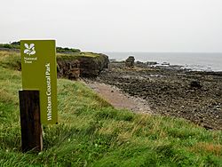
Whitburn Coastal Park.
-
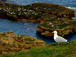
Gull resting on the cliffs between Whitburn and Marsden
-
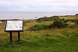
Information board in Whitburn Coastal Park.


Shops, Fun, and Games

Whitburn has many shops, including convenience stores, a butcher, an ice-cream shop, and antique stores. There are also pubs.
Cornthwaite Park is the main park in Whitburn. It was built in the 1960s and has beautiful flower beds, trees, a playground for kids, a bowling green, and tennis courts.
If you like sports, Whitburn has a cricket club that started in 1862. There's also Whitburn Golf Club nearby.
Schools in Whitburn
Whitburn has three schools:
- Whitburn Village Primary School
- Marsden Primary School
- Whitburn Church of England Academy (a secondary school)
All three schools have received "Good" ratings in their latest inspections.
| Primary School Performance (2019) | ||||
|---|---|---|---|---|
| Whitburn Village Primary School | Marsden Primary School | Local average | England average | |
| % of pupils meeting expected standard | 63 | 72 | 66 | 65 |
| % of pupils achieving at a higher standard | 6 | 16 | 12 | 11 |
| Whitburn C of E Academy Performance (2019) | |||
|---|---|---|---|
| Whitburn C of E Academy | Local average | England average | |
| % of pupils with Grade 5 or above in English & maths GCSE | 50 | 34 | 43 |
| % of pupils staying in education or entering employment | 97 | 92 | 94 |
| Attainment 8 score | 52.5 | 42.6 | 46.7 |
Churches in Whitburn
Whitburn has three churches:
- Whitburn Parish Church
- St Vincent's Catholic Church
- Whitburn Methodist Church
Whitburn Parish Church is the oldest building in the village. It was built in the 1200s. The top of its tower was added in the 1400s. After the Spanish Armada attacked England in 1588, two Spanish ships crashed on Whitburn Rocks. It's thought that two bells from one of these ships were put in Whitburn Church when it was repaired.
-
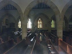
Interior of Whitburn Parish Church.
-
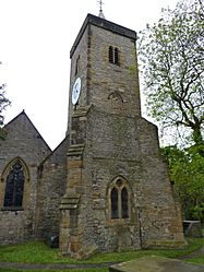
Spire of Whitburn Parish Church.
-
Exterior of Whitburn Methodist Church.


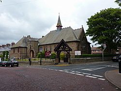
Saint Vincent's Catholic Church is a smaller church built in the 1950s. Whitburn Methodist Church was built in 1881, replacing an older chapel.
Getting Around Whitburn

Whitburn is on the A183 road, which connects Sunderland to South Shields. For a long time, Whitburn was quite isolated. A road connecting the Bents to Sunderland was built in 1865. The main north-south road (now the A183) wasn't finished until 1929. By the 1920s, buses regularly ran on this road.
There are no railway lines in Whitburn, so you can't get there directly by Tyne and Wear Metro. The closest Metro stations are East Boldon and Seaburn. Buses from Go North East and Stagecoach North East serve the area.
Famous People from Whitburn
Many interesting people have connections to Whitburn:
- Thomas Elliot Harrison – an engineer who lived and died in Whitburn.
- Jimmy Seed – a footballer who played for Tottenham Hotspur and won the FA Cup in 1921. He grew up in Whitburn.
- Jack Young and Billy Henderson – footballers who played for West Ham United in the 1923 FA Cup Final. They were born in Whitburn.
- Jack Smith – a footballer for Portsmouth Football Club. Born in Whitburn.
- Jack Weddle – a footballer for Portsmouth and Blackburn Rovers. He lived in Whitburn.
- Sep Smith – a footballer for Leicester City F.C.. Born in Whitburn.
- Bill Robinson – a footballer for Sunderland and Charlton Athletic. Born in Whitburn.
- Dave Clelland – a Scottish footballer who died in Whitburn.
- Julie Elliott – a Labour Party MP. Born in Whitburn.
- Nadine Shah – a musician who grew up in Whitburn.
