
County Durham facts for kids
Quick facts for kids
County Durham
Durham
|
|||||||||||||||||||||||||||||||
|---|---|---|---|---|---|---|---|---|---|---|---|---|---|---|---|---|---|---|---|---|---|---|---|---|---|---|---|---|---|---|---|
|
|
|||||||||||||||||||||||||||||||
 Ceremonial Durham Durham in England Comparison of differing boundaries (historic in grey, ceremonial in blue) Comparison of differing boundaries |
|||||||||||||||||||||||||||||||
| Sovereign state | United Kingdom | ||||||||||||||||||||||||||||||
| Constituent country | England | ||||||||||||||||||||||||||||||
| Region | North East England | ||||||||||||||||||||||||||||||
| Established | Ancient | ||||||||||||||||||||||||||||||
| Time zone | UTC±00:00 (Greenwich Mean Time) | ||||||||||||||||||||||||||||||
| • Summer (DST) | UTC+01:00 (British Summer Time) | ||||||||||||||||||||||||||||||
| Members of Parliament | List | ||||||||||||||||||||||||||||||
| Police | Durham Constabulary Cleveland Police |
||||||||||||||||||||||||||||||
|
|||||||||||||||||||||||||||||||
).jpg)
).jpg)
.jpg)

County Durham, also known simply as Durham, is a ceremonial county in North East England. It shares borders with Northumberland and Tyne and Wear to the north. To the east, you'll find the North Sea, while North Yorkshire is to the south and Cumbria to the west. The biggest town in the county is Darlington.
The county covers an area of about 2,721 square kilometers and has a population of around 857,800 people. Most of the people live in the eastern part of the county. The south-east is part of the Teesside area, which also stretches into North Yorkshire. After Darlington, the largest towns are Hartlepool, Stockton-on-Tees, and Durham City. For local government, County Durham is split into four main areas: County Durham, Darlington, Hartlepool, and part of Stockton-on-Tees.
The western part of the county is home to some of the North Pennines uplands, which is a beautiful national landscape. Rivers like the Tees and Wear start in these hills and flow east, creating the valleys of Teesdale and Weardale. The eastern part of the county is flatter, and the rivers wind through it. The coastline is a special area known for its tall limestone and dolomite cliffs.
The area that is now County Durham was once on the edge of Roman Britain. You can still find Roman remains at places like Binchester Roman Fort. Later, during the Anglo-Saxon period, it was part of the Kingdom of Northumbria. In 995, the city of Durham was founded by monks. They were looking for a safe place from Viking raids to keep the relics of St Cuthbert. Durham Cathedral was rebuilt after the Norman Conquest. Today, it is a World Heritage Site along with Durham Castle.
By the late Middle Ages, the county was almost like its own mini-country, ruled by the bishops of Durham. It also acted as a buffer zone between England and Scotland. In the 1800s, County Durham became very industrial, with many collieries (coal mines) opening. The Stockton and Darlington Railway, the world's first public railway to use steam trains, opened in 1825. Most coal mines closed in the late 1900s, but the county's coal mining history is still celebrated at the yearly Durham Miners' Gala.
Contents
- What's in a Name? Understanding County Durham's Name
- Exploring County Durham's Rich History
- Geography of County Durham
- How County Durham is Governed Today
- Emergency Services in County Durham
- People and Places in County Durham
- Economy of County Durham
- Culture and Heritage
- Education in County Durham
- Fun Places to Visit in County Durham
- Images for kids
- See also
What's in a Name? Understanding County Durham's Name
The ceremonial county is officially called Durham. However, it's often known as County Durham. This is quite unusual for an English county, as it's the only one commonly called "County" something. This special name comes from its unique history. For centuries, the bishops of Durham ruled this area almost like their own kingdom, known as the County Palatine of Durham. This meant it was outside the usual way counties were run in England.
Even today, the name can be a bit confusing:
- The law that created the current local council in 2009 called the area "the county of County Durham."
- The council itself is called Durham County Council. So, the word "County" is sometimes used and sometimes not!
- The old postal area was called "County Durham" to tell it apart from the city of Durham.
Exploring County Durham's Rich History
How Did County Durham Begin?
The area that is now County Durham has a long and interesting past.
Early Kingdoms and Viking Raids
Around AD 547, an Angle leader named Ida started the kingdom of Bernicia. He chose a strong defensive spot at Bamburgh. Later, in AD 604, Ida's grandson, Æthelfrith, joined Bernicia with another kingdom called Deira. This created the powerful Kingdom of Northumbria. At its biggest, Northumbria stretched from the River Humber to the River Forth.
However, arguments within the kingdom and stronger neighbours led to its decline. The arrival of the Vikings made things worse. In AD 867, the Vikings took over the Deiran part of the kingdom, which became known as Jórvík. The land that would become County Durham then sat on the border with the Viking-controlled areas.
The Founding of Durham City
In AD 995, a group of monks who were carrying the remains of St Cuthbert settled in a place called Dunholm, which is now Durham. They chose this spot because the River Wear formed a horseshoe shape around it, making it easy to defend. They built a church for St Cuthbert's remains, which started as wood and later became stone.
Over time, the bishops of Durham slowly gained control of the land that would become County Durham. This area was given special status and was known by names like "Liberty of Durham" or "Liberty of St Cuthbert's Land." The bishops had special powers because it was believed that King Ecgfrith of Northumbria had given a large area to St Cuthbert way back in 684.

After the Norman invasion, it took a while for the new government to fully control northern England. The bishops of Durham argued that their land was outside the usual English county system. By the 1300s, it was accepted that Durham was a special area where the bishop appointed his own sheriff. This area became known as the "County Palatine of Durham."
How Was County Durham Governed in the Past?
Historic Boundaries and Changes

The historic County Durham included the area between the Pennines in the west, the River Tees in the south, the North Sea in the east, and the Rivers Tyne and Derwent in the north. It also had some smaller parts, called exclaves, located within other counties like Northumberland and Yorkshire. These exclaves were eventually merged with the counties around them in 1844. The main boundaries stayed the same until the local government changes in 1972.
Norman Influence and Castles
After the Battle of Hastings, William the Conqueror tried to control Northumbria. However, the people of the region were rebellious. In 1069, a large Norman army was sent to Durham City but was defeated by Northumbrian forces. William then carried out the "Harrying of the North" to stop rebellions, but County Durham was mostly spared.
Some of the best examples of the Norman period are Durham Cathedral and Durham Castle. You can also see several old churches from that time.
_(33802921566).jpg)
The Power of the Prince-Bishops
Until the 1400s, the most important official in the Palatinate was the steward. The bishops of Durham had huge powers, almost like a king in their own lands. They could raise an army, make their own coins, and collect taxes. As long as they stayed loyal to the King of England, they could rule almost independently. This was important because Durham was a "buffer state" between England and Scotland.
The bishops also had the power to appoint judges and offer pardons. However, the English Crown slowly tried to reduce the bishops' power. In 1536, a law was passed that took away some of their rights, like pardoning crimes. The palatinate was officially ended in 1646 but brought back after the Restoration. Finally, in 1836, the bishop's special powers were fully transferred to the Crown.

Wars and Parliament
During the 15th-century Wars of the Roses, Henry VI visited Durham. In the Great Rebellion of 1642, Durham supported Parliament. After the Battle of Marston Moor in 1644, the area came under Parliament's control.
In 1654, County Durham was first allowed to send members to Parliament. After 1660, the county and the city of Durham each sent two members. Over time, more towns in the county gained the right to have their own representatives in Parliament.
Geography of County Durham
Towns and Green Spaces
The historic county boundaries are different from the current ones. For example, the ceremonial county includes Darlington, Hartlepool, and part of Stockton-on-Tees. The historic county also included areas now in Tyne and Wear, like Sunderland and Gateshead.
County Durham has a "Green Belt" area in the north. This is a protected zone around cities like Durham and Chester-le-Street. It helps stop towns from spreading too much and keeps green spaces open.
Landscape and Nature

The western part of County Durham has many Carboniferous rocks. The county includes a large part of the North Pennines, which is a beautiful Area of Outstanding Natural Beauty. The highest point in historic County Durham is Burnhope Seat, which is 746 meters (2,448 feet) high. It's located between Weardale and Teesdale.
The two main valleys, Teesdale and Weardale, along with the surrounding hills, are great for hillwalking. The scenery is wild and remote, with lots of grass, peat bogs, and heather moorland on the lower slopes.
Weather in County Durham
| Weather chart for County Durham | |||||||||||||||||||||||||||||||||||||||||||||||
|---|---|---|---|---|---|---|---|---|---|---|---|---|---|---|---|---|---|---|---|---|---|---|---|---|---|---|---|---|---|---|---|---|---|---|---|---|---|---|---|---|---|---|---|---|---|---|---|
| J | F | M | A | M | J | J | A | S | O | N | D | ||||||||||||||||||||||||||||||||||||
|
56
6
1
|
39
7
1
|
51
9
2
|
52
11
3
|
50
15
6
|
55
17
9
|
45
20
11
|
61
20
11
|
58
17
9
|
57
13
6
|
62
9
3
|
59
7
2
|
||||||||||||||||||||||||||||||||||||
| temperatures in °C precipitation totals in mm |
|||||||||||||||||||||||||||||||||||||||||||||||
|
Imperial conversion
|
|||||||||||||||||||||||||||||||||||||||||||||||
The weather in County Durham, based on figures from 1981 to 2010, shows typical British weather. Summers are mild, and winters are cool. It gets a moderate amount of rain throughout the year.
| Climate data for Durham 102m asl, 1981–2010, extremes 1850– | |||||||||||||
|---|---|---|---|---|---|---|---|---|---|---|---|---|---|
| Month | Jan | Feb | Mar | Apr | May | Jun | Jul | Aug | Sep | Oct | Nov | Dec | Year |
| Record high °C (°F) | 16.7 (62.1) |
17.4 (63.3) |
21.7 (71.1) |
24.1 (75.4) |
27.8 (82.0) |
30.6 (87.1) |
31.0 (87.8) |
32.5 (90.5) |
30.0 (86.0) |
25.0 (77.0) |
19.4 (66.9) |
15.9 (60.6) |
32.5 (90.5) |
| Mean daily maximum °C (°F) | 6.6 (43.9) |
7.2 (45.0) |
9.5 (49.1) |
11.9 (53.4) |
15.0 (59.0) |
17.6 (63.7) |
20.1 (68.2) |
19.8 (67.6) |
17.2 (63.0) |
13.3 (55.9) |
9.4 (48.9) |
6.7 (44.1) |
12.9 (55.2) |
| Mean daily minimum °C (°F) | 0.9 (33.6) |
0.9 (33.6) |
2.3 (36.1) |
3.7 (38.7) |
6.1 (43.0) |
9.0 (48.2) |
11.1 (52.0) |
11.0 (51.8) |
9.0 (48.2) |
6.3 (43.3) |
3.4 (38.1) |
1.1 (34.0) |
5.4 (41.7) |
| Record low °C (°F) | −17.2 (1.0) |
−18.3 (−0.9) |
−15 (5) |
−11.1 (12.0) |
−4.4 (24.1) |
−1.1 (30.0) |
1.1 (34.0) |
0.6 (33.1) |
−1.1 (30.0) |
−5.5 (22.1) |
−8.8 (16.2) |
−16.6 (2.1) |
−18.3 (−0.9) |
| Average rainfall mm (inches) | 52.3 (2.06) |
41.8 (1.65) |
44.6 (1.76) |
52.7 (2.07) |
44.2 (1.74) |
55.4 (2.18) |
54.0 (2.13) |
60.8 (2.39) |
55.4 (2.18) |
60.9 (2.40) |
72.0 (2.83) |
57.0 (2.24) |
651.1 (25.63) |
| Mean monthly sunshine hours | 58.6 | 80.3 | 115.5 | 150.3 | 181.7 | 164.8 | 172.3 | 167.3 | 134.5 | 102.8 | 66.4 | 51.2 | 1,445.4 |
| Source 1: Met Office | |||||||||||||
| Source 2: NEForum | |||||||||||||
How County Durham is Governed Today
County Durham is part of England and has a lord lieutenant and a high sheriff. These are ceremonial roles.
The ceremonial county is divided into four main administrative areas:
| Area name | Council | Council headquarters | Established |
|---|---|---|---|
| Durham | Durham County Council | County Hall, Durham | 1 April 2009 |
| Borough of Darlington | Darlington Borough Council | Darlington Town Hall, Darlington | c. 1995 |
| Stockton-on-Tees | Stockton-on-Tees Borough Council | c. 1995 | |
| Hartlepool | Hartlepool Borough Council | c. 1995 |
For administrative purposes, the "County of Durham" usually refers only to the area managed by Durham County Council. The other three areas are separate councils.
Many towns in the county have their own town councils, like Barnard Castle, Bishop Auckland, and Seaham.
Changes in Governance Over Time
From 1836 to 1974
From 1836, County Durham's administration started to become more like other English counties. Laws were passed to remove the special powers of the bishop and change the county's structure.
In 1889, the ceremonial and administrative counties were created. Some large towns like Darlington and Sunderland became "county boroughs." This meant they managed their own affairs but were still part of the ceremonial county.
In 1968, the County Borough of Teesside was formed, which included parts of Durham and North Yorkshire.
From 1974 to Today

.svg)
From 1974 to 1996, the ceremonial county was divided into eight districts. In 1996, the county of Cleveland was abolished. Its boroughs of Hartlepool and Stockton-on-Tees (north of the River Tees) then became part of the ceremonial County Durham.
On April 1, 2009, the seven smaller districts within the main County Durham area merged. They formed a single, larger council called Durham County Council, which now acts as a unitary authority. This means it handles all local government services for that area.
Parliamentary Representation
The county boundaries used for electing Members of Parliament (MPs) are those from 1974 to 1996. This area elects seven MPs. In the 2019 General Election, four of these MPs were from the Conservative Party and three were from the Labour Party.
Emergency Services in County Durham
The police and fire services cover the ceremonial county boundaries from 1974-96.
- Durham Constabulary is the police force.
- County Durham and Darlington Fire and Rescue Service handles fire and rescue for most of the county.
- Cleveland Police and Cleveland Fire Brigade cover the Hartlepool and Stockton-on-Tees areas.
The North East Ambulance Service NHS Trust provides ambulance services for the whole North East of England. Air ambulance services are provided by the Great North Air Ambulance, which has a base in Eaglescliffe.
The Teesdale and Weardale Search and Mountain Rescue Team helps with search and rescue missions in the county.
People and Places in County Durham
Population and Jobs
| # | Local authority | 2011 census |
|---|---|---|
| – | Ceremonial county | 853,213 |
| 1 | District of County Durham | 513,242 |
| 2 | Borough of Stockton-on-Tees (north Tees) | 136,079 |
| 3 | Borough of Darlington | 105,564 |
| 4 | Borough of Hartlepool | 92,028 |
In 2016, the total population of the ceremonial county was estimated to be around 857,800 people.
Historically, many people in County Durham worked in coal mining. In 1921, over 157,000 people were employed in coal mines. Today, less than 1% of the population works in agriculture, and deep-coal mining has ended.
Where People Live
County Durham is mostly rural, especially in the west. Many smaller towns like Crook, Bishop Auckland, and Peterlee grew during the Industrial Revolution because of the coal mines. The south-east of the county, between Hartlepool and Darlington, is part of the larger Teesside area. The north-east, near the border with Tyne and Wear, is part of the Tyneside and Wearside urban areas.

Most residents of County Durham are White British (96.6%). About 77% of the county's population are Christian, while 22% have no religion.
Economy of County Durham
Local Businesses
County Durham is home to various businesses. For example, Phileas Fogg snacks are made in Consett. CAV Aerospace makes ice protection systems for aircraft. Thomas Swan, an international chemicals company, is in Crookhall.

Many well-known companies have had factories here. Black & Decker and Electrolux once had large factories in Spennymoor. Husqvarna-Flymo, which makes hover mowers, is in Newton Aycliffe. GlaxoSmithKline has a site in Barnard Castle that makes medicines.
Culture and Heritage
Mining and Industry's Impact

In the 1800s, many colliery villages were built to house the growing number of coal miners. People came from all over the UK, including Cornwall, Northumberland, and Scotland, as well as from Ireland, to work in the mines and related industries like railways and shipbuilding. This created a unique culture, language, and sense of identity that still exists today.
The Durham Miners' Gala, first held in 1871, became a huge celebration of coal mining culture and trade unionism. Although most deep-coal mines have now closed, the Gala continues to be a very important event, with more and more banners returning each year as communities remember their mining heritage.

Art and Creativity
In 1930, the Spennymoor Settlement (also known as the Pitman's Academy) opened. It helped unemployed miners find creative outlets like painting, woodwork, and theatre. It also provided education and social support during tough economic times. Famous artists like Norman Cornish and Tom McGuinness were part of this settlement. Their artworks often show scenes of mining life and the communities they lived in.
In 2017, The Mining Art Gallery opened in Bishop Auckland. It displays art by County Durham artists and others, showing the mining culture of the region.
Music and Local Talent
County Durham has a rich history of Northumbrian music, with roots going back to the 7th and 8th centuries. Folk music is a strong tradition, with instruments like the guitar, fiddle, and the unique Northumbrian smallpipe.
The "Stories of Sanctuary" project in Durham City uses photography, stories, poetry, and music to help people share their experiences of seeking sanctuary. This project connects to Durham's history as a place of refuge.
Many famous musicians and songwriters were born or grew up in the county, including Paddy McAloon, Jez Lowe, and Karen Harding.
County Durham's Flag

County Durham has its own flag, which was officially registered in 2013. It was designed by Katie, Holly, and James Moffatt.
The flag features St Cuthbert's cross, combined with the county's traditional blue and gold colours. March 20th is celebrated as County Durham Day.
Education in County Durham
Universities and Colleges
Durham University is located in Durham city and is one of the oldest universities in England. Teesside University also has a campus in Darlington.
There are several colleges throughout the county, offering further education:
- Bede Sixth Form College, Billingham
- Bishop Auckland College
- Carmel College Sixth Form, Darlington
- Darlington College
- Derwentside College, Consett
- Durham Sixth Form Centre, Durham
- East Durham College, Durham and Peterlee
- Hartlepool College of Further Education
- Hartlepool Sixth Form College
- New College Durham, Durham
- Queen Elizabeth Sixth Form College, Darlington
- Stockton Sixth Form College
- St Bede’s Catholic Academy and Sixth Form College Lanchester
Fun Places to Visit in County Durham
| Key | |
| Owned by the National Trust | |
| Owned by English Heritage | |
| Owned by the Forestry Commission | |
| A Country Park | |
| An Accessible open space | |
| Museum (free) | |
| Museum (charges entry fee) | |
| Heritage railway | |
| Historic House | |
|
|
Gallery
-
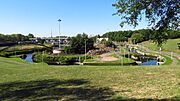
Tees Barrage International White Water Course
-
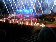
Kynren
-
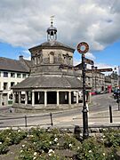
Butter Market, Barnard Castle
.jpg)


Images for kids
-
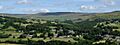
Middleton-in-Teesdale
-
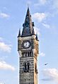
Darlington clock tower
-
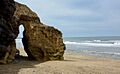
The coast near Seaham
See also
 In Spanish: Condado de Durham para niños
