Burnhope Seat facts for kids
Quick facts for kids Burnhope Seat |
|
|---|---|

Burnhope Seat Summit
|
|
| Highest point | |
| Elevation | 747 m (2,451 ft) |
| Prominence | 190 m (620 ft) |
| Parent peak | Cross Fell |
| Listing | Hewitt, Marilyn, Nuttall |
| Geography | |
| Location | Cumbria and County Durham, England |
| Parent range | North Pennines |
| OS grid | NY785375 |
| Topo map | OS Landranger 91 |
Burnhope Seat is a tall, open moorland hill, also known as a fell, located in the beautiful North Pennines area of northern England. This region is so special it's called an Area of Outstanding Natural Beauty (AONB). The fell sits between the starting points of three important rivers: the Tees, the South Tyne, and the Wear.
The very top of Burnhope Seat is split by the border between two counties, County Durham and Cumbria. Long ago, this area was part of historic Cumberland. A special marker called a trig point is found on the summit. This trig point marks the highest spot in historic County Durham. However, the actual highest point of the mountain is about 400 meters to the west, just over the border into historic Cumberland, and it's 1 meter taller!
Some people might think Mickle Fell, south of Teesdale, is the highest point in County Durham. But this isn't quite right. While Mickle Fell is now managed by Durham County Council, it was historically part of North Riding of Yorkshire. So, Burnhope Seat holds the record for historic County Durham.
Contents
What Burnhope Seat Looks Like
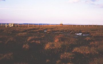
Burnhope Seat looks a lot like other high hills in the Pennines. The top of the fell is mostly flat and can be quite wet. It's covered in tough, clumpy grass called tussock grass and squishy peat bog. This kind of land is often found in places with lots of rain and cool temperatures.
How to Visit Burnhope Seat
Getting to Burnhope Seat is fairly easy. A road called the B6277 road passes within 2 kilometers of the summit. This road connects the towns of Alston and Middleton-in-Teesdale. It offers the simplest way to start your climb to the top.
You can also hike up the hill from Weardale. This route is part of a longer walk around Burnhope Reservoir. It's a great way to explore the high-level areas of the Pennines.
Skiing at Yad Moss
On the northwest side of Burnhope Seat, you'll find some ski-tows. This area is known as the Yad Moss ski facility. Ski-tows are like small lifts that pull skiers up the slope. Recently, this ski area has been improved by Sport England, making it even better for winter sports enthusiasts.
Access for Everyone
The entire area around Burnhope Seat is known as "access land." This means that, thanks to the Countryside and Rights of Way Act 2000, people are allowed to walk freely across this land. It's a great way for everyone to enjoy the beautiful countryside.
 | Bayard Rustin |
 | Jeannette Carter |
 | Jeremiah A. Brown |

