
Ordnance Survey facts for kids
| Welsh: Arolwg Ordnans | |
| Agency overview | |
|---|---|
| Formed | 1791 |
| Jurisdiction | Great Britain |
| Headquarters | Southampton, England, UK 50°56′16″N 1°28′17″W / 50.9378°N 1.4713°W OS grid SU 373 155 |
| Employees | 1,244 |
| Minister responsible |
|
| Agency executive |
|
| Parent agency | Department for Science, Innovation and Technology |
| Website | |
The Ordnance Survey (OS) is the official map-making group for Great Britain. Its name comes from its original military purpose. "Ordnance" means military supplies, and "surveying" means measuring land. The OS first started mapping Scotland after a rebellion in 1745. They also needed maps during the Napoleonic Wars to prepare for possible invasions.
Since 2015, Ordnance Survey has been a company owned by the government. It is still fully public, but it runs like a business. The Ordnance Survey Board reports to the Secretary of State for Science, Innovation and Technology.
Today, paper maps are only a small part of what OS does. They create digital map data, online tools for planning routes, and mobile apps. They also make many other location-based products for businesses, the government, and everyday people.
OS maps are usually called "large-scale" or "small-scale." Large-scale maps are very detailed. They include 1:2,500 maps for cities and 1:10,000 maps for other areas. These detailed maps are often used by professionals, like those planning land use. They were put into digital form in the 1980s. Small-scale maps are for fun activities like hiking. These include the 1:25,000 "Explorer" maps and the 1:50,000 "Landranger" maps. These are still sold as paper maps.
Ordnance Survey maps are protected by copyright for 50 years after they are made. Some special libraries keep almost all the old OS maps.
Contents
How the Ordnance Survey Started
Why did the Ordnance Survey begin?


.jpg)

Detail from 1901 Ordnance Survey map of the Imperial fortress colony of Bermuda (showing St. George's Town and St. George's Garrison), compiled from surveys carried out between 1897 and 1899 by Lieutenant Arthur Johnson Savage, Royal Engineers.
|
The Ordnance Survey started after a rebellion in Scotland in 1745. The British Army realized they didn't have good maps of the Scottish Highlands. This made it hard to find rebels. In 1747, Lieutenant-Colonel David Watson suggested making a map of the Highlands to help calm the area. King George II asked Watson to create a military map.
One of Watson's helpers was William Roy. Roy later became a General in the Royal Engineers. He was very important in setting up the Ordnance Survey. He helped measure the distance between French and British observatories. This work led to the "Principal Triangulation of Great Britain," which was a huge project to accurately measure the whole country. Roy's skills helped the Ordnance Survey become known for its high standards.
Mapping officially began in 1790 under Roy. The Board of Ordnance, a military group, started a national survey from the south coast of England. In 1791, they got a new, improved measuring tool called a theodolite. They began mapping southern Great Britain using a 5-mile baseline near what is now Heathrow Airport.
Early Maps and Challenges
In 1801, the first one-inch-to-the-mile map (1:63,360 scale) was published. It showed the county of Kent. Soon after, a map of Essex followed. The Kent map was private, but the Essex maps were published by the Ordnance Survey. These maps ignored county borders, which became the standard for future OS maps.
Over the next 20 years, about a third of England and Wales was mapped. This was done under William Mudge. Other military needs sometimes slowed down the mapping. By 1810, most of southern England was mapped. However, these maps were taken off sale for a few years due to security worries. By 1840, almost all of England and Wales was covered by the one-inch survey.
Surveying was very tough work. For example, Major Thomas Frederick Colby, a long-serving Director General, walked 586 miles in 22 days in 1819 just to check an area. In 1824, Colby and his team moved to Ireland to work on a six-inches-to-the-mile (1:10,560) survey. This survey of Ireland was finished in 1846.
Colby also created a system for collecting place names. This system was first used in Ireland. Surveyors had to find the correct spelling of names by asking local people and checking old documents. This helped make maps clear and accurate. Sometimes mistakes were made, like the spelling of Scafell and Scafell Pike, but these names stuck.

The British Geological Survey started in 1835 as part of the Ordnance Survey. It mapped the geology of the country. The quality of English and Scottish maps was also improved by skilled engravers. When Colby retired in 1846, the six-inch maps of Ireland were complete. People in England wanted similar detailed maps.
Moving Headquarters and New Leaders
| Survey Act 1870 | |
|---|---|
| Act of Parliament | |
|
|
| Long title | An Act to amend the Law relating to the Surveys of Great Britain, Ireland, and the Isle of Man. |
| Citation | 33 & 34 Vict. c. 13 |
| Dates | |
| Royal assent | 12 May 1870 |
| Other legislation | |
| Amends | Statute Law Revision Act 1883 |
After a fire at the Tower of London, the Ordnance Survey headquarters moved to Southampton in 1841. Major Henry James became Director General in 1854. He was keen on mapping northern England at a scale of 1:2,500. In 1855, the Ordnance Survey became part of the War Office. Later, in 1870, it moved to the Office of Works.
The main survey of the United Kingdom was finished by 1841. It was greatly improved by Alexander Ross Clarke in 1858. He also completed the first measurement of land heights across the country.
Mapping Great Britain: The County Series
| Ordnance Survey Act 1841 | |
|---|---|
| Act of Parliament | |
|
|
|
| Long title | An Act to authorize and facilitate the Completion of a Survey of Great Britain, Berwick upon Tweed, and the Isle of Man. |
| Citation | 4 & 5 Vict. c. 30 |
| Dates | |
| Royal assent | 21 June 1841 |
| Other legislation | |
| Amended by |
|
|
Status: Partially repealed
|
|
| Text of statute as originally enacted | |
| Text of the Ordnance Survey Act 1841 as in force today (including any amendments) within the United Kingdom, from legislation.gov.uk | |

After mapping Ireland, people wanted similar detailed maps for England and Wales. This led to the Ordnance Survey Act 1841. This law allowed surveyors to enter private land to do their work.
From the 1840s, the Ordnance Survey focused on the "County Series" for Great Britain. They started mapping the whole country, county by county, at six inches to the mile (1:10,560). In 1854, even more detailed "twenty-five inch" maps (1:2500) were introduced. The six-inch maps were then made from these more detailed ones. The first versions of these maps were finished by the 1890s.
The OS also made "restricted" maps for the War Office. These maps showed military details like dockyards and army camps. These areas were often left blank on regular maps.
Mapping Cities and Towns
From 1840, the OS started mapping towns at very large scales, like 1:1056 or 1:500. The 1:500 scale was called the "sanitary scale" because it helped with planning water and sewer systems. However, these very detailed maps didn't sell well, so the OS stopped updating them often.
London had its own very detailed OS survey between 1862 and 1872. This survey needed 326 map sheets to cover the city. A second edition was made between 1891 and 1895, needing even more sheets due to the city's growth.
Later, around 1911-1913, many 1:2500 maps of built-up areas were enlarged to 1:1250. This was for land valuation and tax purposes. These detailed maps were replaced by the Ordnance Survey National Grid maps after World War II.
The 20th Century and Modernization


During World War I and World War II, the Ordnance Survey made many maps for military use in France, Belgium, Italy, and other countries.
After World War I, Colonel Charles Close helped increase map sales to the public. In 1920, O. G. S. Crawford started using aerial photography to help with archaeology.
In 1922, Northern Ireland got its own mapping agency, the Ordnance Survey of Northern Ireland. The Irish Free State also created the Ordnance Survey of Ireland. So, the original Ordnance Survey focused only on Great Britain.
In 1935, a committee reviewed the OS's future. Major-General Malcolm MacLeod started a huge project to re-measure Great Britain. This involved building concrete "trig points" on hilltops. These points were used for very accurate measurements.
The committee's report shaped the OS for the 20th century. The metric national grid reference system was launched. A new 1:25,000-scale map series was introduced. The one-inch maps were replaced by 1:50,000-scale maps in the 1970s.
The OS headquarters in Southampton was badly damaged during World War II bombings in 1940. Staff moved to other buildings and temporary places. They made maps of Europe for the D-Day invasion. In 1969, a new, purpose-built headquarters opened in Maybush, Southampton.
By 1995, the Ordnance Survey had put all its 230,000 maps into digital form. This made the UK the first country to have all its large-scale maps available electronically. By the late 1990s, new technology meant they didn't need huge areas for storing maps or making printing plates by hand.
In 1990, the Ordnance Survey became an "Executive Agency." This gave it more independence. In 1999, it became a "trading fund," meaning it had to cover its costs by selling its products.
The 21st Century: Digital Focus


In 2010, OS announced they would stop printing maps themselves. This ended over 200 years of in-house printing. The OS Explorer and OS Landranger maps were then printed by another company.
In 2009, construction began on a new headquarters in Adanac Park, outside Southampton. By 2011, almost all staff had moved to the new "Explorer House" building. Prince Philip officially opened the new building in October 2011.
In 2015, the OS changed from a trading fund to a government-owned company. It is still fully owned by the UK government. In September 2015, a TV documentary called A Very British Map: The Ordnance Survey Story explored the history of the OS.
In June 2019, Steve Blair became the Chief Executive of the Ordnance Survey. The OS also supported the "Slow Ways" project, which encourages people to walk on less-used paths. In February 2023, ownership of Ordnance Survey Ltd moved to the new Department for Science, Innovation and Technology.
What Kinds of Maps Does OS Make?

The Ordnance Survey makes many different paper maps and digital map products.
OS MasterMap: The Super Detailed Map
OS MasterMap is the OS's main digital product, launched in 2001. It's a huge database that records almost every fixed feature in Great Britain. Each feature has a unique ID number called a TOID. This ID is linked to a shape that shows where the feature is on the ground.
OS MasterMap comes in different "layers":
- Topography: This is the main layer. It shows features like buildings and areas of plants.
- Integrated Transport Network: This layer shows roads and railways. It's used in many satnav systems. This layer was replaced in 2019 by OS MasterMap Highways Network.
- Imagery: This layer has aerial photos of the land.
- Address: This layer adds every address in the UK to the map.
- Address 2: This adds more address details, like buildings with many people living in them, or places without a postal address.
As of 2020, MasterMap mainly includes Topography and Imagery. The cost to use OS MasterMap data depends on the area, the layers you need, and how long you want to use it. You can print maps from OS MasterMap data that are as detailed as a traditional 1:1250 paper map.
The Ordnance Survey says that OS MasterMap data is updated very often, so it's always current. This mapping project is very detailed and unique. By 2011, there were 450 million TOIDs in the database.
Maps for Businesses
The Ordnance Survey makes many products for businesses, like utility companies and local councils. This data is given on discs or downloaded from the internet. Businesses need to buy a license to use OS data. Some main products are:
- OS MasterMap: The most detailed map, showing individual buildings.
- OS VectorMap Local: A customizable map at 1:10,000 scale.
- Meridian 2, Strategi: Mid-scale maps.
- Boundary-Line: Maps showing official borders like counties.
- Raster versions of leisure maps: Digital versions of the 1:10,000, 1:25,000, 1:50,000, and 1:250,000 maps.
Maps for Fun and Travel

OS makes many maps for people to use for fun:
| Number | Scale | Title |
|---|---|---|
| 1 | 1:100 000 | Cornwall |
| 3 | 1:110 000 | Lake District & Cumbria |
| 4 | 1:100 000 | Peak District & Derbyshire |
| 5 | 1:130 000 | Devon & Somerset West |
| 8 | 1:100 000 | The Cotswolds & Gloucestershire |
| 10 | 1:175 000 | North & Mid Wales |
| 11 | 1:175 000 | South & Mid Wales |
| 12 | 1:500 000 | Scotland |
- Tour: These are single-sheet maps covering areas like a county. They show main roads, tourist info, and some footpaths. There are eight maps in this series.
- OS Landranger (1:50,000): These are general-purpose maps with pink covers. 204 sheets cover all of Great Britain and the Isle of Man. They show all footpaths but with less detail than Explorer maps.
- OS Landranger Active (1:50,000): These are waterproof, plastic-laminated versions of some Landranger maps.
- OS Explorer (1:25,000): These maps are made for walkers and cyclists. They have orange covers. 403 sheets cover all of Great Britain (but not the Isle of Man). They are the most detailed leisure maps and show all types of footpaths. Some "OL" (Outdoor Leisure) sheets cover popular areas like the Lake District. These maps now come with a mobile download version.
- OS Explorer Active (1:25,000): These are waterproof versions of Explorer maps.
- Activity Maps: These are special maps for specific activities, like off-road cycling.
- Road (1:250,000): A series of eight maps for drivers, covering Great Britain. This series was brought back in 2016.
OS Apps for Your Phone
In 2013, the Ordnance Survey released its first official app, OS MapFinder. Since then, they have added more apps.
- OS Maps: This free app for iOS and Android lets you see maps on your device. You can plan and record routes and share them. You can subscribe to download high-resolution OS Landranger and OS Explorer maps. These maps can be used offline without Wi-Fi or mobile signal.
- OS Maps Web: This is a website version of OS Maps. You can plan custom routes and print maps from your computer.
- OS Locate: Launched in 2014, this free app for iOS and Android quickly shows your exact location. It displays grid references, latitude, longitude, and altitude. OS Locate uses your device's GPS and works without a mobile signal.
Custom Maps
The Ordnance Survey also offers OS Custom Made. This service lets you choose the exact area you want on a map. You can get maps at 1:50,000 or 1:25,000 scale. You can also add your own titles and cover pictures for folded maps.
The OS can also make more detailed custom maps at 1:1,250 or 1:500 from its digital data.
Maps for Schools
The Ordnance Survey provides copies of its maps for schools. These are used in geography lessons in Britain and other countries.
In the 2000s, the OS gave a free OS Explorer Map to every 11-year-old in UK primary schools. Over 6 million maps were given away by 2010. This program was replaced by free access to the Digimap for Schools service.
The OS also has "MapZone," a website for kids with learning tools and map games. They publish a journal for geography teachers called Mapping News.
Old Maps You Can See for Free
The National Library of Scotland lets you see OS maps from 1840 to 1970 for free on their website. The Society for All British and Irish Road Enthusiasts (SABRE) also has a large collection of old OS maps available online.
How Maps Are Made: Cartography and Geodesy
The first OS maps were made using triangulation. This method involves measuring angles from known points to find the exact location of other points. For the second survey in 1934, many concrete "trig points" were built on hilltops. Their exact positions were found by triangulation.
Today, OS maps are mostly made from aerial photographs taken from planes. However, many trig points are still there. The OS also has surveyors who visit areas that can't be mapped from the air, like places hidden by trees. They aim to map new features like motorways within six months of them being built. Modern surveying uses Global Navigation Satellite System (GNSS) technology, like GPS, for very precise measurements. The OS has a network of GNSS stations called "OS Net" that other organizations can use.
OS maps of Great Britain use the Ordnance Survey National Grid to show locations, instead of latitude and longitude. This Grid is called OSGB36. It was created after the 1936–1953 survey.
For measuring heights, the OS uses a system based on "Ordnance Datum Newlyn." This is a height reference point based on the average sea level measured in Newlyn, Cornwall, between 1915 and 1921.
The OS's CartoDesign team is in charge of how maps look. They design all new products and services.
Research and Data Access
The Ordnance Survey has a research department that studies different areas of geographical information science. This includes how people understand maps, how to simplify maps, and how to use data from satellites.
The OS works with universities and supports students doing research. Most OS products are available to UK universities through the Digimap agreement.
Open Data and Free Access
The Ordnance Survey has a very important role in providing geographic data in the UK. For a long time, it had to charge for its data to cover its costs. However, many people wanted some of this data to be free.
In 2010, the government announced that some Ordnance Survey data sets would be released for free use. This was called OS OpenData. It uses a license that allows people to use the data as long as they say where it came from. Some people were disappointed that the popular leisure maps (1:50,000 and 1:25,000) were not included. The OS argued that if they didn't charge for these, the government would have to pay a lot of money to collect the data.
In June 2018, following recommendations from the Geospatial Commission, more parts of OS MasterMap were made available for free under the Open Government Licence. This included property boundaries and other detailed information. Other data became free for small businesses. These are available through online tools called APIs on the OS Data Hub.
Old Maps for Everyone
Old Ordnance Survey maps are generally available to the public because they are covered by "Crown Copyright." This means works older than fifty years are free to use. However, the Ordnance Survey doesn't provide historical maps for free directly. Instead, they work with other companies to sell "enhanced" copies.
Wikimedia Commons has complete digital copies of many old OS map series.
Images for kids
-
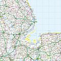
Grid square TF from the Ordnance Survey National Grid, shown at a scale of 1:250,000. The map shows the Wash and the North Sea, as well as places within the counties of Lincolnshire, Cambridgeshire and Norfolk.
-
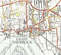
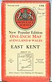
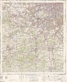
Part of an Ordnance Survey map, at the scale of one inch to the mile, from a New Popular Edition map published in 1946
-
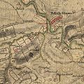
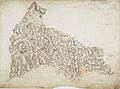
Pollokshaws on Roy's Military Survey of Scotland (1747–1755)
-
The original draftsman's drawings for the area around St Columb Major in Cornwall, made in 1810.
-
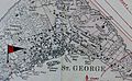
Detail from 1901 Ordnance Survey map of the Imperial fortress colony of Bermuda (showing St. George's Town and St. George's Garrison), compiled from surveys carried out between 1897 and 1899 by Lieutenant Arthur Johnson Savage, Royal Engineers.
-
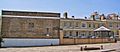
The former headquarters of the Ordnance Survey in London Road, Southampton (2005)
-
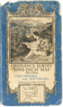
The cover of the 5th series OS map Chelmsford and Southend sheet 108. Art by Ellis Martin
-
Front cover of a one-inch to the mile New Popular Edition, from 1945
-
Detailed scan of a complete 7th series sheet
-

Former Ordnance Survey headquarters in Maybush, Southampton, used from 1969 until 2011
-

Headquarters in Adanac Park opened in 2011
-

Ordnance Survey maps on sale
-
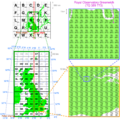
Illustration of the Ordnance Survey National Grid coordinate system, with Royal Observatory Greenwich as an example
See also
 In Spanish: Ordnance Survey para niños
