
Satellite navigation facts for kids

A satellite navigation system, often called satnav, is a clever way to find out exactly where you are. It uses signals from special machines orbiting Earth called satellites. These signals help small electronic devices, like the ones in your phone or car, figure out their exact spot on Earth.
Contents
Satnav systems work by using a network of satellites in space. Each satellite sends out radio signals that carry very precise time information. Your satnav receiver on the ground listens to these signals from several satellites at once.
Finding Your Position
By measuring how long it takes for the signals to reach it from different satellites, your receiver can calculate its distance from each one. Imagine drawing circles around each satellite, with the radius being the distance. Where these circles meet is your exact location. This helps the receiver find its longitude, latitude, and even its altitude (how high it is).
Keeping Time Accurate
The signals from satellites also help your device know the exact current time. This is super important because even tiny errors in time can lead to big mistakes in figuring out your position. This precise timekeeping is called synchronisation.
A satnav system that covers the whole world is known as a Global Navigation Satellite System (GNSS). The most famous GNSS is the Global Positioning System (GPS), which was created by the United States. Other countries and regions also have their own GNSS, like Russia's GLONASS, Europe's Galileo, and China's BeiDou. These systems make it possible for people all over the world to use satnav for many different things.
Satnav systems are used for many things every day. They help people find their way when driving, walking, or flying. Pilots use them to navigate planes, and ships use them to cross oceans safely. Farmers use satnav to guide their tractors, which helps them plant crops more efficiently. Even emergency services use satnav to find people in need quickly.
Images for kids
-
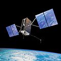
The U.S. Space Force's Global Positioning System was the first global satellite navigation system and was the first to be provided as a free global service.
-
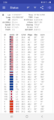
GNSS satellites used for navigation on a smartphone in 2021
-
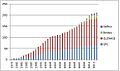
Launched GNSS satellites 1978 to 2014


See also

