
Scafell facts for kids
Quick facts for kids Scafell |
|
|---|---|

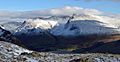
The Scafell massif from Middle Fell. Scafell is on the right. From this angle Scafell appears higher than Scafell Pike.
|
|
| Highest point | |
| Elevation | 964 m (3,163 ft) |
| Prominence | 133 m (436 ft) |
| Parent peak | Scafell Pike |
| Listing | Hewitt, Wainwright, Nuttall |
| Geography | |

Scafell
Location in Lake District

Scafell
Location in the Borough of Copeland
|
|
| Location | Cumbria, England |
| Parent range | Lake District, Southern Fells |
| OS grid | NY206064 |
| Topo map | OS Landrangers 89, 90, Explorer OL6 |
| Listed summits of Scafell | ||||
| Name | Grid ref | Height | Status | |
|---|---|---|---|---|
| Symond's Knott | NY207067 | 959 m (3,146 ft) | Nuttall | |
Scafell (sometimes spelled Sca Fell) is a large mountain in the English Lake District. It is part of the Southern Fells. Standing at 964 metres (3,162 ft) tall, it is the second-highest mountain in England. Its taller neighbour, Scafell Pike, is separated from Scafell by a dip called Mickledore col.
Contents
Exploring Scafell's Landscape
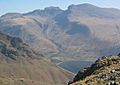
Scafell sits between Wasdale to the west and upper Eskdale to the east. The highest part of the mountain is a ridge that runs south from Mickledore. This ridge goes as far as Slight Side, which many guidebooks consider a separate mountain.
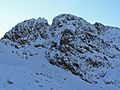
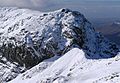
The sides of Scafell look very different from each other. The western slopes are smooth. They don't have much plant life at higher parts. But on the east, there are impressive cliffs that hang over upper Eskdale. On the north side, Scafell Crag offers some of the most amazing rock views in the Lake District.
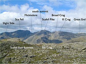
From the narrow ridge of Mickledore, the northern side of Scafell rises steeply. This makes it a difficult barrier for hikers trying to walk along the ridge. Many find it's a cliff only for rock climbers. At the top of the climb from Mickledore is Symonds Knott, which is the northern peak.
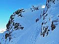
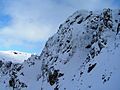
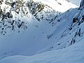
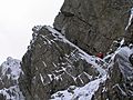
The wall of cliffs, including Scafell Crag and the East Buttress, has two main ways through. One is Lord's Rake, a path filled with loose rocks. It used to be a scrambling route. However, rockfalls in 2002 and later have made it unsafe for regular hikers. The other way through the cliffs is Broad Stand. These are sloping steps that go down from Symonds Knott towards Mickledore. But they become very steep near Mickledore and are only safe for experienced rock climbers.
The main summit of Scafell is a bit south of the saddle. It is surrounded by many stones. An easy ridge then goes south over Long Green to Slight Side. To the east, you can find Cam Spout Crag and a beautiful high waterfall.
Beyond Slight Side, there is a rough, hilly area with many rocky tops and several tarns (small mountain lakes). The descent southward eventually ends in Lower Eskdale. Southwest of Scafell, below the Great How cliffs, is Burnmoor Tarn. This is one of the largest tarns in the Lake District. It is about 40 feet (12 meters) deep and has fish like trout, perch, and pike. Near its southern shore is Burnmoor Lodge, which used to be a keeper's cottage.
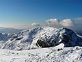
Scafell's Summit Views
The main summit of Scafell has a large cairn (a pile of stones) on a short rocky ridge. To the north, there is a dip marked by a large stone cross. Then, there is a rocky climb to Symonds Knott, the north peak. From here, you can see straight down to Mickledore.
The view from Scafell is very different from its taller neighbour, Scafell Pike. From Scafell, you get a great view of Wastwater and the flat land near the coast. You can also see the Western Fells, along with Bowfell and the Coniston Fells.
Routes to the Top
Climbing from Wasdale
A popular way to climb Scafell is from Wastwater. You follow the main Scafell Pike footpath to Hollow Stones. Then, you go up to Lord's Rake. You can follow Lord's Rake all the way. Or, near the top of the first dip, you can take a path called the West Wall Traverse. This path leads closer to the summit. However, parts of Lord's Rake are now dangerous due to unstable rocks from a rockfall in 2001. Another option is to climb from the Burnmoor track via Green How. But this route misses the impressive rock scenery of Scafell Crag.
Climbing from Eskdale
A nice, but long, alternative route starts from Boot in Eskdale. You follow the River Esk upstream. Then, you scramble up to the summit by way of Foxes Tarn. You can return by a gentler path across the moorland, going past Burnmoor Tarn. Another route from Eskdale is the Terrace route, which starts at Wha House and first climbs Slight Side.
Crossing from Scafell Pike

The path from Scafell Pike to Scafell (or the other way around) can be tricky. What looks like a direct route is actually very risky. You have to cross Broad Stand crag, which is a dangerous and exposed scramble. It has caused many accidents. It is usually treated as a rock climb, meaning you need ropes and safety gear. Hikers are warned about its dangers. The dangers are more obvious when coming from Scafell Pike. But when coming from Scafell, you lose a lot of height before you see the danger.
Instead, there are two safer walking routes, but they involve losing some height. The first is via Foxes Tarn to the east of Scafell summit. The second is via Lord's Rake and the West Wall traverse. All routes go via Mickledore.
Rock Climbing on Scafell Crag
Scafell Crag, which is the huge north side of Scafell, and the East Buttress (which hangs over Mickledore Col) are famous for rock climbing. Many historic and modern rock climbs have taken place here. The history of climbing on these cliffs is written about in a book called "Nowt but a fleein' thing" by The Fell and Rock Climbing Club.
How Scafell Got Its Name
Before about 1920, the name "Scawfell" was used most often. Famous people like William Wordsworth, who wrote a popular guide to the Lake District, used this spelling. Many local hotel owners and tour guides also used "Scawfell." However, maps printed by national publishers often used "Scafell."
The change to the shorter spelling, "Scafell," seems to have started with the Donald Map in 1774. This map had some errors in place names. The Ordnance Survey then continued using "Scafell" from 1867. The Donald map was the first to name many mountains in the Lake District. Before 1867, maps used both spellings about equally. But most people in the area said "Scawfell."
It was once thought that Scafell was the highest mountain in this part of the Lake District. It looks taller from many directions than its actual higher neighbour, Scafell Pike. The three peaks to the north (Scafell Pike, Ill Crag, and Broad Crag) were once called the "Pikes of Scawfell."
The heights of many fells were first measured by John Dalton and Jonathan Otley. Dorothy Wordsworth found out in 1818 that "The Pikes" (Scafell Pike) was higher than Scafell. This was likely from Otley's map and guidebook. Once Scafell Pike was known as England's highest mountain, the Scafell Range was divided into several individually named parts. This process was finished before Jonathan Otley died in 1856.
Images for kids
-
Scafell massif from Middle Fell.
-
Scafell massif from Middle Fell
-
Lords Rake, Scafell, Cumbria - 2010
-
Scafell Crag, Cumbria, from the north, 2010
-
Scafell from Scafell Pike, - 2010.
-
Detail in snow of Broadstand, Scafell, Cumbria - 2010
-
Scafell Crag with Lord's Rake on the left.
-
The ascent from Wasdale to Mickledore (on the right)
-
Botterill's slab on Scafell Crag, first climbed in 1903.


See also
 In Spanish: Sca Fell para niños
