
Bowfell facts for kids
Quick facts for kids Bowfell |
|
|---|---|

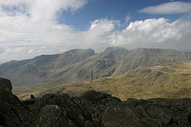
Bowfell from Shelter Crags, about a
mile south along the ridge |
|
| Highest point | |
| Elevation | 902 m (2,959 ft) |
| Prominence | 146 m (479 ft) |
| Parent peak | Scafell Pike |
| Listing | Hewitt, Nuttall, Wainwright, Sub-Marilyn |
| Geography | |

Bowfell
Location in Lake District

Bowfell
Location in the Borough of Copeland

Bowfell
Location in South Lakeland
|
|
| Location | Cumbria, England |
| Parent range | Lake District, Southern Fells |
| OS grid | NY245064 |
| Topo map | OS Landrangers 89, 90 Explorer OL6 |
| Listed summits of Bowfell | ||||
| Name | Grid ref | Height | Status | |
|---|---|---|---|---|
| Bowfell North Top | NY244070 | 866 m (2,840 ft) | Nuttall | |
Bowfell is a cool, pyramid-shaped mountain right in the middle of England's Lake District. It's part of the Southern Fells area. This mountain is the sixth-highest in the Lake District. It's also one of the most popular mountains for hikers to explore. A famous fell walker, Alfred Wainwright, even called it one of his 'best half dozen' Lake District fells.
Contents
Exploring Bowfell's Landscape
The Southern Fells have some of the highest land in England. Imagine a big horseshoe shape of mountains. It starts with Scafell and Scafell Pike in the west. Then it curves around the north of Upper Eskdale. This curve includes mountains like Great End, Esk Pike, Bowfell, and Crinkle Crags.
Valleys Around Bowfell
Bowfell touches three well-known valleys. It stands at the top of Great Langdale. Its eastern ridge splits into two parts: Mickleden and Oxendale. To the north, you'll find the Langstrath part of Borrowdale. From all these valleys, Bowfell looks amazing. It has a cone-shaped top sitting on a wider, flatter summit area.
Ore Gap and Angle Tarn
To the northwest of Bowfell, the main ridge dips down. This dip is called Ore Gap. It gets its name from its reddish soil, which is rich in haematite. Below this dip, on the northern side, is Angle Tarn. This round lake sits in a corrie, which is like a bowl-shaped hollow. Small trout swim in its deep waters, about 50 feet down. Water flows out of Angle Tarn into Langstrath Beck, which goes towards Stonethwaite.
South of Ore Gap, a stream called Yeastyrigg Gill flows. This stream is the main source of Lingcove Beck. It flows into the wild upper Eskdale. Past Ore Gap, the ridge climbs up three stony levels. This leads to the white-rocked top of Esk Pike.
Three Tarns and Crinkle Crags
South of Bowfell, the ridge drops steeply to a place called Three Tarns. This dip separates Bowfell from Crinkle Crags. It's named for the small pools there. Sometimes there are two, but after rain, there can be more! A stream called Busco Sike flows east from here. It's the longest stream feeding Oxendale Beck in Great Langdale.
Bowfell's Eastern Ridges
Bowfell has two other ridges that stretch out to the east.
- The Band: This ridge starts from the southern part of the summit. It goes down towards the valley floor. The Band separates Oxendale from Mickleden. It heads straight for Stool End Farm. About halfway down, The Band has a small peak called White Stones. Most guidebooks don't consider it very important.
- Rossett Pike Ridge: The second ridge starts from the northern part of the summit. It crosses Rossett Hause. This is a sharp dip at the top of Rossett Gill. From there, it goes towards Rossett Pike. This ridge then connects to the Central Fells. It forms the northern wall of Great Langdale as it crosses Martcrag Moor, heading towards the Langdale Pikes.
What Bowfell is Made Of
The main rocks on Bowfell are volcaniclastic sandstones. These are from the Seathwaite Fell Formation. You can also find layers of andesite rock near the top. This rock formed from volcanic ash and fragments. There are also pebbly sandstone and breccias (rocks made of sharp, broken pieces) from the Pavey Ark Member that cross the fell.
Reaching the Summit
The top of Bowfell is a ridge that runs north to south. The final pyramid-shaped peak is near the southwest corner. There are steep rock faces, called crags, on three sides.
Impressive Crags and Features
- Bowfell Links: The southern face is a huge wall of crag. It has nine vertical gullies, which are like deep channels. At the bottom of these, there are matching piles of loose rock called scree. Climbing these is not fun or safe because the rocks move a lot.
- Eastern Face: This side has many cool features. These include Flat Crag, Cambridge Crag, and the Bowfell Buttress. The last two are great for rock climbing.
- Great Slab: Flat Crag includes the Great Slab. This is a huge, tilted sheet of rock that looks exactly like its name! At the bottom of the Great Slab, a spring gushes out of the bare rock. Some say no water tastes better!
- Climber's Traverse: Below these crags, there's a narrow path called the Climber's Traverse. It's a great high-level walking route to the summit. This path mostly stays flat as it goes around many of Bowfell's dramatic crags. It finally reaches the summit by a rocky path called the River of Boulders. This path runs next to the Great Slab.
- Hanging Knotts: On the northeast corner of the summit ridge, you'll find Hanging Knotts. This is a complicated set of rock faces and outcrops. They look down onto Angle Tarn.
The View from the Top
The very top of Bowfell has a small pile of loose rocks, not a big cairn. The view from here is amazing! It's even better because the final slope is steep, so nothing blocks your view close up. You can see every major group of fells in the Lake District from this fantastic spot. You can see the Helvellyn range from one end to the other. You can also see the Langdale Pikes across Langdale. But the best part of the view is Scafell Pike, which looks huge above Eskdale.
Ways to Climb Bowfell
Many people choose to climb Bowfell using The Band route. Other ways from Langdale go up via Rossett Gill and Three Tarns. You can also reach Bowfell from Stonethwaite by going past Angle Tarn. This way is quite long.
Another long but beautiful way is to walk up Eskdale from Brotherikeld. This route reaches the ridge at either Ore Gap or Three Tarns. You can also climb Bowfell indirectly. This means going over other peaks like Crinkle Crags, Esk Pike, or Rossett Pike first. The summit can also be reached from the top of Wrynose Pass. You follow a public path that starts near the Three Shire Stone. This path heads northwest and takes you over the tops of Cold Pike and Long Top.
Gallery
-
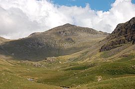
The pyramid shape of Bowfell viewed from Lingcove
-
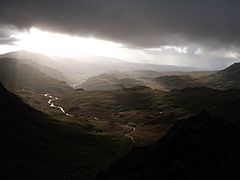
Looking south-west from just under Bow Fell summit towards Eskdale under darkening skies
-
The view south-east from the Great Slab, looking towards Pike of Blisco
-
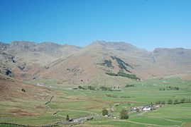
Bowfell from Great Langdale
-
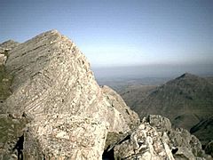
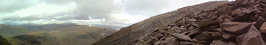
Scafells from Bowfell
-
Great Slab on Bowfell, from the 'river of boulders'


