
List of hill passes of the Lake District facts for kids
The hill passes of the Lake District are special routes that let people travel between valleys without having to go all the way around tall mountains. For a long time, getting around the Lake District in northwest England was tough because of its steep valleys. So, people created paths over the mountain ridges, usually finding the easiest way across a col (the lowest point on a ridge between two peaks).
Even as far back as Roman times, people used these ridge routes for longer journeys. Later, in the 1800s, when hiking became popular, these old paths were used again. This article lists 40 important hill passes within the Lake District National Park.

Contents
About the Lake District Passes
The Lake District National Park was created in 1951. It covers a huge area of over 2,000 square kilometres (770 sq mi). Even though only about 42,000 people live there, more than 10 million visitors come every year. Most people are drawn to the stunning lakes and fells (hills).
How the Mountains Were Made (Geology)
About 500 million years ago, the land that is now the Lake District was under an ocean. The ocean floor was slowly being pushed under another land plate. This process changed the rocks into the Skiddaw slates we see in the north and west.
Then, for about 5 million years, volcanoes erupted, creating the Borrowdale volcanic rocks. These included lava and ash that piled up at least 6,000 metres (20,000 ft) deep! This was a huge amount of rock, even by world standards.
Later, around 420 million years ago, giant landmasses collided. This caused the slate rocks to bend and the harder volcanic rocks to crack. The whole area was then pushed up by a large mass of granite rock from below, mostly during the Carboniferous period. Over time, the high ground slowly wore away.
Today, the slaty rocks in the north form smooth hills with sharp ridges, like Skiddaw, which is 931 metres (3,054 ft) high. In the middle, the volcanic rocks create a bumpy landscape, home to Scafell Pike, England's highest mountain at 978 metres (3,209 ft). The southern part of the Lake District is generally less hilly.
Shaped by Ice (Glaciation)
.jpg)
Starting about 2 million years ago, huge glaciers moved across the land. They carved out the landscape we see today.
The glaciers followed existing streams that had formed along cracks in the rocks. As they moved, they ground away the land, creating the steep-sided valleys that are so famous here. Many of these valleys later filled with water, becoming long, narrow ribbon lakes. For example, on the Rossett Pass, a glacier carved out the Mickleden and Great Langdale valleys below. The Lake District is known for its mountain ridges spreading out from a central area, with glaciers flowing outwards along the old stream beds.
People and the Passes (Human History)
For a long time, the Lake District was perfect for raising sheep. From medieval times (and possibly even Roman times), there was also a big mining industry for rocks and minerals.
The Romans built important military roads. One went north-south through the eastern part of the region at High Street. Another went through the Hardknott and Wrynose passes, connecting forts at Ravenglass and Ambleside.
Traveling between valleys was hard because of the steep mountain ridges. Before roads for wheeled carts were built in the late 1700s, people used long lines of horses to carry goods. They often preferred ridge routes for long distances, like Esk Hause and Stake Pass. However, for shorter trips within the region, people tried to stay as low as possible to avoid big detours, so they usually avoided mountain tops and high ridges.
In the late 1700s, the Lake District started to become popular with travelers. Poets, known as the "Lake Poets", began to see the lakes and mountains as beautiful, not scary. In Victorian times, more tourists arrived, especially after the Kendal and Windermere Railway was built.
In the mid-1900s, Alfred Wainwright helped make hiking even more popular with his books, A Pictorial Guide to the Lakeland Fells. These books described detailed routes to the main mountain tops. He knew the area very well and used many of the old paths, even though his books weren't just about the passes themselves.
Hill Passes List
The maps below show the passes, along with major lakes, valleys, and some important mountains. The first map uses numbers for the passes, and the second map shows their names. The different colors just help to tell nearby routes apart.
- Maps of Lake District National Park showing hill passes
-
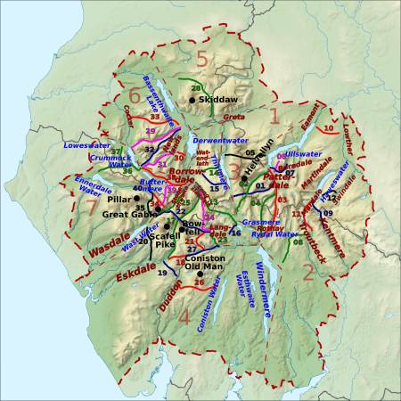
Showing pass numbers, lakes, valleys and mountains
-
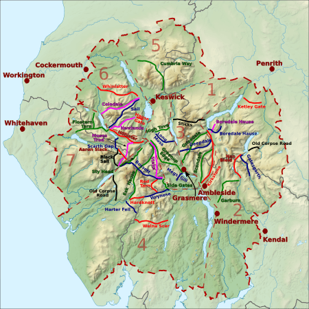
Showing names of passes and towns


| Reference Name (path type) |
Height/ OS grid |
Start: Valley/ place/ OS grid |
End: Valley/ place/ OS grid |
Notes | Image |
|---|---|---|---|---|---|
| 1/01/blue Deepdale Hause (footpath/path) |
655 m (2,149 ft)/ NY360125 |
Patterdale/ Bridgend/ NY398143 |
Thirlmere/ Dunmail Raise/ NY327117 |
Part way the footpath becomes an undefined type of path. |  |
| 1/02/green Grisedale Hause (bridleway) |
590 m (1,940 ft)/ NY350117 |
Patterdale/ Grisedale Bridge/ NY382156 |
Grasmere/ Mill Bridge/ NY336091 |
 |
|
| 1/03/red Kirkstone Pass (road) |
454 m (1,489 ft)/ NY401082 |
Patterdale/ Bridge End/ NY399143 |
Rothay / Ambleside/ NY376047 |
North: A592 (continuing to the town of Windermere). South: unclassified road. |  |
| 1/04/green Scandale Pass (footpath) |
516 m (1,693 ft)/ NY387095 |
Patterdale/ Caudale Bridge/ NY401110 |
Rothay Ambleside/ NY384082 |
 |
|
| 1/05/black Sticks Pass (bridleway) |
738 m (2,421 ft)/ NY341182 |
Patterdale/ Glencoyne/ NY387186 |
Thirlmere/ Legburthwaite/ NY318189 |
.jpg) |
|
| 2/06/magenta Boredale Hause (bridleway) |
399 m (1,309 ft)/ NY408157 |
Patterdale/ Hartsop/ NY405132 |
Boredale/ Boredale Head/ NY418169 |
Or Boardale Hause |  |
| 2/07/blue Boredale Hause (bridleway) |
500 m (1,600 ft)/ NY417157 |
Patterdale/ Patterdale/ NY400161 |
Martindale/ Dale Head/ NY433164 |
Boredale Hause is not the high point of this route. |  |
| 2/08/green Garburn Pass (bridleway) |
447 m (1,467 ft)/ NY433043 |
Kentmere/ Kentmere/ NY455044 |
Troutbeck/ (village)/ NY423006 |
The southern part is a restricted byway that is now closed to vehicles. | .jpg) |
| 2/09/blue Gatescarth Pass (restricted byway) |
572 m (1,877 ft)/ NY473092 |
Mardale/ Mardale Head/ NY469107 |
Longsleddale/ Sadgill/ NY483056 |
Restricted byway – open to all except motor vehicles (but permits are available). |  |
| 2/10/red Pass over Ketley Gate (bridleway) |
323 m (1,060 ft)/ NY489223 |
Eamont/ Pooley Bridge/ NY479235 |
Lowther/ Helton/ NY506210 |
Wainwright does not mention a name. | .jpg) |
| 2/11/red Nan Bield Pass (bridleway) |
640 m (2,100 ft)/ NY452095 |
Mardale/ Mardale Head/ NY468107 |
Kentmere/ Hallow Bank/ NY464053 |
.jpg) |
|
| 2/12/black Old Corpse Road, Mardale (bridleway) |
512 m (1,680 ft)/ NY493122 |
Mardale/ (Mardale Green) NY479118 |
Swindale/ Swindale Head/ NY504125 |
 |
|
| 3/13/green Pass over Greenup Edge (bridleway) |
608 m (1,995 ft)/ NY285105 |
Rothay/ Easedale/ NY327084 |
Stonethwaite/ Stonethwaite/ NY263138 |
 |
|
| 3/14/green Pass over High Tove (footpath) |
508 m (1,667 ft)/ NY288165 |
Watendlath Valley/ Watendlath/ NY275163 |
Thirlmere/ Armboth/ NY304171 |
The traditional footpath crosses the summit of High Tove. | .jpg) |
| 3/15/blue Pass over Long Moss (bridleway) |
525 m (1,722 ft)/ NY296139 |
Watendlath Valley/ Watendlath/ NY275163 |
Thirlmere/ Wythburn/ NY319131 |
 |
|
| 3/16/blue Pass near Megs Gill (footpath) |
230 m (750 ft)/ NY328063 |
Rothay/ Grasmere/ NY333071 |
Great Langdale/ Chapel Stile/ NY322055 |
Highest of three passes. | .jpg) |
| 4/17/green Esk Hause (footpath) |
759 m (2,490 ft)/ NY233081 |
Borrowdale/ Seathwaite/ NY235121 |
Eskdale/ Jubilee Bridge/ NY211011 |
Just north there is col by a shelter that is often wrongly called "Esk Hause". | .jpg) |
| 4/18/red Hardknott Pass (road) |
393 m (1,289 ft)/ NY231014 |
Duddon/ Cockley Beck/ NY246016 |
Eskdale/ Dalegarth station/ NY174007 |
Unclassified public road, the gradient reaches 1 in 3 33%. | .jpg) |
| 4/19/blue Pass near Harter Fell (bridleway) |
355 m (1,165 ft)/ SD210993 |
Duddon/ Seathwaite/ SD230974 |
Eskdale/ Hardknott Castle/ NY213011 |
.jpg) |
|
| 4/20/black Old Corpse Road, Wasdale (bridleway) |
298 m (978 ft)/ NY184055 |
Eskdale/ Boot/ NY176012 |
Wasdale/ Wasdale Head/ NY186083 |
_-_geograph.org.uk_-_1341047.jpg) |
|
| 4/21/red Red Tarn Pass (footpath) |
530 m (1,740 ft)/ NY267039 |
Great Langdale/ Oxendale/ NY276056 |
Little Langdale/ Three Shire Stone/ NY275026 |
See Pike of Blisco and Cold Pike. |  |
| 4/22/blue Rossett Pass (bridleway) |
610 m (2,000 ft)/ NY246075 |
Great Langdale/ Mickleden/ NY284061 |
Wasdale/ Wasdale Head NY187086 |
There is a higher col on this pass at 722 metres (2,369 ft) near Esk Hause. | .jpg) |
| 4/23/green Side Gates road (road) |
224 m (735 ft)/ NY289051 |
Great Langdale/ Rossett/ NY285059 |
Little Langdale/ Ting Mound/ NY302033 |
Also called Blea Tarn road. | .jpg) |
| 4/24/magenta Stake Pass (bridleway) |
480 m (1,570 ft)/ NY265087 |
Borrowdale/ Rosthwaite/ NY259147 |
Great Langdale/ Mickleden/ NY284061 |
On the Cumbria Way. | .jpg) |
| 4/25/green Sty Head Pass (bridleway) |
488 m (1,601 ft)/ NY218094 |
Borrowdale/ Seathwaite/ NY234120 |
Wasdale/ Wasdale Head/ NY187086 |
Between Borrowdale and Wasdale (but also Langdale and Eskdale). | .jpg) |
| 4/26/red Walna Scar Road (restricted byway) |
608 m (1,995 ft)/ SD258964 |
Coniston Water/ Coniston/ SD301975 |
Duddon/ Seathwaite/ SD232967 |
Restricted byway – open to all except motor vehicles. | .jpg) |
| 4/27/blue Wrynose Pass (road) |
393 m (1,289 ft)/ NY277027 |
Duddon/ Cockley Beck/ NY246016 |
Little Langdale/ Fell Foot/ NY300031 |
Unclassified public road. |  |
| 5/28/green Cumbria Way, Skiddaw Forest (bridleway) |
488 m (1,601 ft)/ NY279305 |
Bassenthwaite/ Peter House Farm/ NY249323 |
Greta/ Gale Road/ NY280253 |
Cumbria Way via Skiddaw House. | .jpg) |
| 6/29/magenta Coledale Hause (footpath) |
603 m (1,978 ft)/ NY189211 |
Newlands/ Braithwaite/ NY227238 |
Crummock/ Lanthwaite/ NY159208 |
See Coledale (Cumbria). |  |
| 6/30/red Hause Gate (bridleway) |
360 m (1,180 ft)/ NY244191 |
Borrowdale/ Manesty/ NY250185 |
Newlands/ Little Town/ NY234195 |
Lucie's path to Catbells in The Tale of Mrs. Tiggy-Winkle. |  |
| 6/31/magenta Newlands Hause (road) |
333 m (1,093 ft)/ NY193176 |
Newlands/ Little Town/ NY230201 |
Buttermere/ (village)/ NY176170 |
Unclassified road. Often called Buttermere Hause. |  |
| 6/32/blue Sail Pass (footpath) |
625 m (2,051 ft)/ NY204204 |
Derwent/ Braithwaite/ NY229231 |
Buttermere/ (village)/ NY173171 |
This pass is far higher and not much shorter than Newlands Hause. | .jpg) |
| 6/33/red Whinlatter Pass (road) |
318 m (1,043 ft)/ NY205245 |
Newlands/ Braithwaite/ NY230236 |
Cocker/ High Lorton/ NY162258 |
B5292, B road. |  |
| 7/34/magenta Aaron Slack (footpath) |
750 m (2,460 ft)/ NY214105 |
Ennerdale/ Black Sail Hut/ NY194123 |
Borrowdale/ Styhead Tarn/ NY234120 |
High point at Windy Gap. Nearby is Sty Head with four onward routes. | .jpg) |
| 7/35/black Black Sail Pass (bridleway) |
545 m (1,788 ft)/ NY191114 |
Wasdale/ Wasdale Head/ NY186087 |
Ennerdale/ Black Sail Hut/ NY194123 |
Black Sail Hut is a Youth Hostel. | .jpg) |
| 7/36/green Floutern Tarn Pass (bridleway) |
416 m (1,365 ft)/ NY121172 |
Buttermere/ (village)/ NY175169 |
Ennerdale/ Whins/ NY098167 |
Goes near Scale Force. | .jpg) |
| 7/37/green Floutern Tarn Pass (bridleway) |
416 m (1,365 ft)/ NY121172 |
Loweswater/ (village)/ NY141209 |
Ennerdale/ Whins/ NY098167 |
A branch off the pass going to Buttermere. |  |
| 7/38/red Honister Pass (road) |
356 m (1,168 ft)/ NY224136 |
Borrowdale/ Seatoller/ NY245136 |
Buttermere/ Gatesgarth/ NY195149 |
B5289, B road. |  |
| 7/39/magenta Moses Trod (footpath) |
660 m (2,170 ft)/ NY209119 |
Borrowdale/ Honister Hause/ NY225135 |
Wasdale/ Wasdale Head/ NY186088 |
An abandoned track for transporting slate. |  |
| 7/40/blue Scarth Gap Pass (bridleway) |
445 m (1,460 ft)/ NY189133 |
Buttermere/ Gatesgarth/ NY194150 |
Ennerdale/ Black Sail Hut/ NY194123 |
 |
How Passes Were Chosen
The hill passes listed here are routes inside the Lake District National Park. They connect two different valleys, and their paths are clearly marked on official maps (like the Ordnance Survey 1:50000 or 1:25000 maps).
We included passes that are called "pass" or "hause" on these maps, as long as a route crossing the ridge is shown. We also added routes that are described as passes in well-known guides, as long as they connect different valleys. A pass doesn't always need a name, but most do. Also, it doesn't always have to cross a col (the lowest point on a ridge), but almost all of them do. We left out a few routes where the climb was very small (less than about 100 metres (330 ft)), especially for paved roads.
