
Colorado Springs, Colorado facts for kids
Quick facts for kids
Colorado Springs
|
|||
|---|---|---|---|
|
Colorado Springs skyline with the
Front Range in the background |
|||
|
|||
| Nicknames:
Olympic City USA,
The Springs |
|||

Location of the City of Colorado Springs in El Paso County, Colorado
|
|||

Colorado Springs
Location in Colorado

Colorado Springs
Location in the United States
|
|||
| Country | |||
| State | |||
| County | El Paso County | ||
| Incorporated | June 19, 1886 | ||
| Government | |||
| • Type | City | ||
| Area | |||
| • Total | 195.761 sq mi (507.019 km2) | ||
| • Land | 195.399 sq mi (506.082 km2) | ||
| • Water | 0.362 sq mi (0.937 km2) | ||
| Elevation | 6,035 ft (1,839 m) | ||
| Population
(2020)
|
|||
| • Total | 478,961 | ||
| • Estimate
(2023)
|
488,664 |
||
| • Rank | 2nd in Colorado 39th in the United States |
||
| • Density | 2,446.660/sq mi (944.6609/km2) | ||
| • Urban | 632,494 (US: 66th) | ||
| • Urban density | 3,156.7/sq mi (1,218.8/km2) | ||
| • Metro | 755,105 (US: 79th) | ||
| • Front Range | 5,055,344 | ||
| GDP | |||
| • Metro | $47.905 billion (2022) | ||
| Time zone | UTC– 07:00 (MST) | ||
| • Summer (DST) | UTC– 06:00 (MDT) | ||
| ZIP codes |
80901–80951, 80960, 80962, 80970, 80977, 80995, 80997
|
||
| Area code | 719 | ||
| FIPS code | 08-16000 | ||
| GNIS feature ID | 2410198 | ||


Colorado Springs is a big city in Colorado, United States. It's the main city in El Paso County. With almost 480,000 people, it's the second largest city in Colorado and the 39th largest in the entire United States.
Colorado Springs is about 70 miles (110 km) south of Denver. It sits at the base of Pikes Peak, a famous mountain that rises over 14,000 feet (4,300 meters) high. The city itself is quite high up, over a mile (6,000 feet or 1,800 meters) above sea level! This makes it the largest city north of Mexico that is more than 6,000 feet high.
Contents
- A Look at Colorado Springs' Past
- Where is Colorado Springs?
- Who Lives in Colorado Springs?
- What Drives the Economy?
- Fun Things to Do in Colorado Springs
- Sports in Olympic City USA
- Parks, Trails, and Open Spaces
- Learning in Colorado Springs
- Getting Around Colorado Springs
- Neighborhoods and Historic Places
- Famous People from Colorado Springs
- Sister Cities Around the World
- Images for kids
- See also
A Look at Colorado Springs' Past

The land where Colorado Springs is now was first home to Native American tribes like the Ute, Arapaho, and Cheyenne. In 1803, this area became part of the United States through the Louisiana Purchase.
How Colorado Springs Started
In 1859, during the Pikes Peak Gold Rush, a settlement called Colorado City was formed. It even served as the capital of the Colorado Territory for a short time in the early 1860s.
In 1871, a group called the Colorado Springs Company planned a new town called Fountain Colony. This town was soon renamed Colorado Springs and officially became a city. Many people from England moved here, earning it the nickname "Little London."
Growing and Changing
Over the years, Colorado Springs grew by adding nearby areas. By the late 1800s, it was an important center for mining.
A famous inventor, Nikola Tesla, even had an experimental station here from 1899 to 1901. He used it to study electricity!
Military City USA
Colorado Springs became very important for the military during World War II.
- In 1941, Fort Carson was set up as a large army base.
- In 1942, Peterson Field (now Peterson Space Force Base) opened as an air base.
During the Cold War, Colorado Springs became a key location for air defense. The North American Aerospace Defense Command (NORAD) built its headquarters inside Cheyenne Mountain Complex, a super-secure underground facility.
Many colleges were also built here, like the University of Colorado Colorado Springs and Pikes Peak State College. In 1977, part of a former air force base became the United States Olympic Training Center.
Recent History
In 2012, a large wildfire called the Waldo Canyon fire caused a lot of damage near the city. It destroyed many homes and forced thousands of people to leave their houses for safety.
Where is Colorado Springs?


Colorado Springs is in a dry, semi-arid area. To the west are the Southern Rocky Mountains, and to the east are wide open plains. It's about an hour's drive south of Denver.
Colorado Springs is the largest city in Colorado by land area. It covers about 196 square miles (507 square kilometers).
What's the Weather Like?
Colorado Springs has a cool, dry winter climate. It gets lots of sunshine, about 243 sunny days each year! It also gets about 16.5 inches (420 mm) of rain every year.
The city is known for having many lightning strikes. This is one reason why Nikola Tesla chose Colorado Springs for his electricity experiments.
Seasons in Colorado Springs

- Winter: December is usually the coldest month. It can get very cold, sometimes below 0°F (–18°C). Snowfall is moderate, about 38 inches (97 cm) per season, but it usually melts quickly because of the sun.
- Spring: March is often the snowiest month.
- Summer: Summers are warm, with July being the warmest month. Temperatures often reach 90°F (32°C) or higher. Evenings are usually cool. Brief thunderstorms are common in July and August.
- Fall: The first frost usually happens around October 2.
The highest temperature ever recorded was 101°F (38°C), and the lowest was –27°F (–33°C).
Who Lives in Colorado Springs?
| Historical population | |||
|---|---|---|---|
| Census | Pop. | %± | |
| 1880 | 4,226 | — | |
| 1890 | 11,140 | 163.6% | |
| 1900 | 21,085 | 89.3% | |
| 1910 | 29,078 | 37.9% | |
| 1920 | 30,105 | 3.5% | |
| 1930 | 33,237 | 10.4% | |
| 1940 | 36,789 | 10.7% | |
| 1950 | 45,472 | 23.6% | |
| 1960 | 70,194 | 54.4% | |
| 1970 | 135,517 | 93.1% | |
| 1980 | 215,105 | 58.7% | |
| 1990 | 281,140 | 30.7% | |
| 2000 | 360,890 | 28.4% | |
| 2010 | 416,427 | 15.4% | |
| 2020 | 478,961 | 15.0% | |
| 2023 (est.) | 488,664 | 17.3% | |
| U.S. Decennial Census | |||
.png)
In 2020, Colorado Springs had a population of 478,961 people. It's a diverse city. The population of the wider Colorado Springs area, including nearby towns, was over 755,000 people in 2020.
What Drives the Economy?
Colorado Springs' economy mainly relies on three things: the military, high-tech companies, and tourism.
Military Presence

Colorado Springs is home to many important military bases and commands. It's sometimes called "Olympic City USA" and also a major "Space City."
- Nearly 45,000 active-duty troops are stationed here.
- The military and defense companies make up over 40% of the local economy.
Key military locations include:
- Peterson Space Force Base: Home to North American Aerospace Defense Command (NORAD) and United States Northern Command (USNORTHCOM) headquarters.
- Schriever Space Force Base: Another important space operations base.
- Cheyenne Mountain Space Force Station: A super-secure command center inside a mountain.
- Fort Carson: A large U.S. Army base.
- United States Air Force Academy: A famous college for future Air Force officers.
Defense and Technology Industries
Many large defense companies have offices in Colorado Springs. These companies build things for the military, like advanced technology and equipment. Some of these companies include Northrop Grumman, Boeing, and Lockheed Martin.
The city also has a history with high-tech companies, especially those making electronics. While some have changed, companies like Keysight Technologies still have important divisions here.
Fun Things to Do in Colorado Springs

Tourism is a big part of Colorado Springs' economy. People love to visit because of the beautiful mountains and many attractions. Over 23 million visitors came to the area in 2018!
Top Attractions

Colorado Springs has over 55 attractions. Some of the most popular include:
- Garden of the Gods: A stunning park with huge red rock formations. It's free to visit and great for hiking and exploring.
- United States Air Force Academy: You can visit parts of this impressive campus.
- Cheyenne Mountain Zoo: A mountain zoo with amazing views.
- United States Olympic & Paralympic Museum: A new museum that opened in 2020, celebrating Olympic and Paralympic athletes.
- Pikes Peak Summit: You can drive, hike, or take a train to the top of this famous mountain. The Manitou and Pikes Peak Railway reopened in 2021.
Yearly Events

The city hosts many fun events throughout the year:
- Colorado Springs Labor Day Lift Off: A big hot air balloon festival every Labor Day weekend.
- GalaxyFest: A comic book convention and science fiction convention in February.
- PrideFest: A pride parade in July.
- Festival of Lights Parade: A festive parade held downtown in December.
Breweries and Religion
Colorado Springs has many craft breweries and microbreweries, with over 30 to choose from.
The city is also known for having many Christian organizations and churches. It's sometimes called "the Evangelical Vatican" because so many religious groups have their headquarters here.
Sports in Olympic City USA

Colorado Springs is called "Olympic City USA" for a good reason! It's home to the United States Olympic & Paralympic Training Center and the main office for the United States Olympic & Paralympic Committee. More than 50 other national sports organizations are also based here.
Ice Skating and Baseball
The city has a strong connection to figure skating. It has hosted major championships many times and is home to the World Figure Skating Museum and Hall of Fame.
For baseball fans, the city has a professional team called the Rocky Mountain Vibes. They play in the Pioneer League.
Pikes Peak International Hill Climb
The Pikes Peak International Hill Climb is a famous car and motorcycle race. It happens every June, where drivers race to the summit of Pikes Peak. It's also known as The Race to the Clouds.
Local Sports Teams
| Name | Sport | Founded | League | Venue |
|---|---|---|---|---|
| Colorado Springs Switchbacks FC | Soccer | 2015 | USL Championship | Weidner Field |
| Rocky Mountain Vibes | Baseball | 2019 | Pioneer League | UCHealth Park |
Many local colleges also have sports teams, including the United States Air Force Academy Falcons and Colorado College Tigers.
Parks, Trails, and Open Spaces
Colorado Springs has a huge system of parks, trails, and open spaces. The city manages over 9,000 acres of parks and 160 miles (260 km) of park trails.
Amazing Parks

.jpg)
- Garden of the Gods: This is a National Natural Landmark with amazing red rock formations. You can hike, bike, and even rock climb here.
- Palmer Park: A large city park with great views.
- Memorial Park: Has sports fields, a swimming pool, and a skateboard park.
- Monument Valley Park: Offers walking and biking paths, and an outdoor swimming pool.
Trails for Adventure
Three main trails connect the area: the New Santa Fe Regional Trail, Pikes Peak Greenway, and Fountain Creek Regional Trail. These trails let you travel from Palmer Lake, through Colorado Springs, all the way to Fountain. Many trails are connected, so you can explore a lot of the city by bike or on foot.
Learning in Colorado Springs
Schools for Kids
Colorado Springs has several public school districts, covering different parts of the city. There are also many private schools, including Catholic schools and other Christian schools.
The state of Colorado also runs the Colorado School for the Deaf and Blind in the city, which helps students up to age 21.
Colleges and Universities

For higher education, Colorado Springs offers several options:
- University of Colorado Colorado Springs (UCCS): A large public university with over 12,000 students.
- Pikes Peak State College: Offers two-year associate degrees.
- United States Air Force Academy: A federal college that trains future Air Force officers.
- Colorado College: A private college established in 1874.
Getting Around Colorado Springs
Main Roads and Highways
The main highway through Colorado Springs is I-25, which runs north and south. Other important roads include State Highway 21 (Powers Boulevard) on the east side and US 24, which goes through downtown and out to the west.
In 2015, voters approved a temporary sales tax increase to help improve roads and infrastructure in the city.
Colorado Springs Airport
Colorado Springs Airport (COS) is the second-largest commercial airport in Colorado. It's also used by Peterson Space Force Base. Several airlines fly in and out of COS, connecting the city to other parts of the country.
Trains and Buses
While there are no passenger trains right now, there are plans for a new train service called Front Range Passenger Rail to connect cities along the Front Range Urban Corridor.

Mountain Metropolitan Transit (MMT) provides public bus service throughout Colorado Springs and nearby towns. There are also intercity bus services like Bustang and Greyhound that connect Colorado Springs to Denver and other cities.
Biking and Walking
Colorado Springs has a growing network of bike lanes and paved trails, totaling over 200 miles (320 km). There's even a local electric bike-share program called PikeRide. The city has a Bike Master Plan to make bicycling even safer and more convenient.
The city is also becoming more walkable, meaning it's easier to get around on foot in many areas.
Neighborhoods and Historic Places
- Banning Lewis Ranch Neighborhood
- Black Forest Neighborhood
- Broadmoor Neighborhood
- Cheyenne Hills Neighborhood
- Downtown
- Ivywild Neighborhood
- Manitou Springs
- Old Colorado City
- Old North End Historic District
- Patty Jewett Neighborhood
- Pikeview/Pinecliff Neighborhood
- Rockrimmon Neighborhood
- Security
- Stetson Hills Neighborhood
- Widefield
- Wolf Ranch Neighborhood
See also National Register of Historic Places in Colorado Springs, Colorado
Famous People from Colorado Springs
Many interesting people have come from Colorado Springs. You can find a list of them in the main article about people from Colorado Springs.
Sister Cities Around the World

Colorado Springs has "sister city" relationships with several cities around the world. These partnerships help people from different countries learn about each other's cultures.
Here are Colorado Springs' sister cities:
 Fujiyoshida, Yamanashi, Japan (since 1962)
 Kaohsiung, Taiwan (since 1983)
 Bishkek, Kyrgyzstan (since 1994)
 Nuevo Casas Grandes, Chihuahua, Mexico (since 1996)
 Canterbury-Bankstown, Sydney, Australia (since 1999)
 Olympia, Peloponnese, Greece (since 2014)
 Kranj, Slovenia (since 2022)
The relationship with Fujiyoshida, Japan, is marked by a special torii gate downtown. This gate was a gift to celebrate the friendship between the two cities. Many of Colorado Springs' sister cities are also located near mountains, just like Colorado Springs!
Images for kids
-
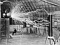
Nikola Tesla sitting in the Colorado Springs Experimental Station with his "magnifying transmitter" generating millions of volts

See also
 In Spanish: Colorado Springs para niños
