
Great Plains facts for kids
Quick facts for kids Great Plains |
|
|---|---|

View of the Great Plains near Lincoln, Nebraska
|
|

Approximate extent of the Great Plains
|
|
| Location | Canada and the United States |
| Coordinates | 37°N 97°W / 37°N 97°W |
| Length | 3,200 km (2,000 mi) |
| Width | 800 km (500 mi) |
| Area | 2,800,000 km2 (1,100,000 sq mi) |
The Great Plains is a huge area of mostly flat land in the middle of North America. It's covered with lots of prairie, steppe, and grassland. This region is west of the Mississippi River in the United States and east of the Rocky Mountains in both the U.S. and Canada.
The Great Plains includes:
- All of Nebraska, North Dakota, and South Dakota.
- Parts of Colorado, Kansas, Minnesota, Montana, New Mexico, Oklahoma, Texas, and Wyoming.
- The southern parts of Alberta, Saskatchewan, and Manitoba in Canada.
This area is famous for its large cattle ranches and dryland farms. In Canada, this part of the Plains is often called the Canadian Prairies.
Contents
What are the Great Plains?
.jpg)
The term "Great Plains" describes a big section of the larger Interior Plains in North America. People also use the term to talk about the Plains Indians or the Plains states.
In Canada, people usually say "prairie" instead of "Great Plains." The official maps in Canada call this area the Interior Plains. So, in Canada, you'll hear about the Prairie Provinces or just "the Prairies."
The Great Plains is also seen as an ecoregion, which means it's an area defined by its plants and animals, especially its prairies and grasslands.
How Big are the Great Plains?

The Great Plains stretches about 800 km (500 mi) (500 miles) from east to west and 3,200 km (2,000 mi) (2000 miles) from north to south. It covers about 1,300,000 km2 (500,000 sq mi) (500,000 square miles).
Long ago, huge herds of American bison lived here. But they were hunted almost to extinction in the mid-to-late 1800s.
The term "Great Plains" became common in the early 1900s. Before that, people often called it the "High Plains" to show it was higher than the "Prairie Plains" to the east. Today, "High Plains" refers to a smaller part of the Great Plains.
What is the Geography of the Great Plains Like?

The Great Plains is the western part of the huge North American Interior Plains. These plains stretch all the way east to the Appalachian Plateau.
The land in the Great Plains generally rises slowly from east to west. It goes from about 180 m (590 ft) (600 feet) in the east to 1,200 m (3,900 ft) to 1,800 m (5,900 ft) (4,000–6,000 feet) near the mountains. The climate is semi-arid, which means it's quite dry. This dryness prevents many trees from growing, so you can see very far across the land.
Even though it's called "Plains," the area isn't perfectly flat. It has different landforms and is sometimes broken up by buttes, escarpments (steep slopes), and valleys. But overall, it's a wide, mostly flat area, so the name "Great Plains" fits well.
The eastern edge of the Great Plains is not a sharp line. It's more about the climate. The line where the annual rainfall is about 500 mm (20 in) (20 inches) is often used as the boundary. This line separates the drier plains from the wetter prairies to the east.
Northern Great Plains
The northern part of the Great Plains includes eastern Montana, northeastern Wyoming, most of North and South Dakota, and the Prairies.

Here, the land is mostly a gently sloping plain. You can see hills that are remnants of harder rock layers. There are also some lava-capped mesas (flat-topped hills) and ridges formed by dikes (rock formations). These show how much the land has been worn away by erosion.
The Missouri River and its branches flow in deep valleys, hundreds of feet below the main plain. This is because the land was lifted up, and the rivers cut down into it. A special feature is the waterfalls on the Missouri River, which were formed when Pleistocene ice sheets changed the river's path.
The Black Hills in western South Dakota are a notable exception. They are like a large island of mountains rising from the plains. Black Elk Peak is the highest point at 2,199 m (7,215 ft) (7,216 feet). These mountains were formed by a dome-like uplift that has been eroded over time.
Intermediate Great Plains

In the middle part of the plains, in southern South Dakota and northern Nebraska, you'll find unique areas called the Badlands. These are very rugged and broken up, with many small valleys and ridges. This happens because of the dry climate, which prevents grass from growing, and the fine soil. When it rains, even small streams carve out their own tiny valleys.
Central Great Plains

The central part of the Great Plains, in eastern Colorado and western Kansas, was once covered by a smooth, gently sloping plain of gravel and sand. This material was carried by rivers flowing from the mountains. Over time, rivers have cut valleys into this plain.
So, the northern plains got their smooth shape from rivers wearing away the land. The central plains got their smooth shape from rivers depositing new gravel and sand.
Southern Great Plains

The southern part of the Great Plains is in western Texas, eastern New Mexico, and western Oklahoma. This area is a high, flat table-land called the Llano Estacado. It's about 240 km (150 mi) (150 miles) east to west and 640 km (400 mi) (400 miles) north to south.
The Llano Estacado is very dry, with only temporary puddles after rain. It's separated from other plains by the valleys of the Canadian River and the Pecos River. On its eastern side, it has a steep edge, about 150 m (490 ft) to 240 m (790 ft) (500 to 800 feet) high. The southern part of this table-land is called the Edwards Plateau.
Ancient History of the Great Plains
During the Cretaceous Period (145 to 66 million years ago), a shallow inland sea called the Western Interior Seaway covered the Great Plains. When this sea dried up, it left behind thick layers of marine deposits and a mostly flat land.
About 25 million years ago, during the Miocene and Pliocene epochs, the climate became good for grasslands to grow. Forests shrank, and grasslands spread widely. This created new places for mammals to live, especially for animals like ungulates (hoofed animals) and glires (rodents) that started eating grass instead of leaves.
Scientists have found many fossils in the Great Plains. These include bones of mammoths, saber-toothed cats, giant sloths, horses, mastodons, and American lions. Most of these large animals became extinct in North America around 13,000 years ago.
Climate of the Great Plains


The Great Plains has a wide range of weather. Winters can be very cold and harsh, while summers are often hot and humid. Winds are usually strong, especially in winter.
Much of the prairies have been turned into farms or pastures by humans.
The 100th meridian west is an imaginary line that roughly divides the Great Plains. West of this line, the area gets less than 500 mm (20 in) (20 inches) of rain per year. This drier part is mostly semi-arid steppe land, used for ranching or some farmland. This region often has long periods of drought, which can cause huge dust storms.
The eastern part of the Great Plains gets more rain. The southern areas have a humid subtropical climate, while the northern and central areas have a humid continental climate.
Many thunderstorms happen in the plains from spring to summer. The southeastern Great Plains is known as Tornado Alley because it has the most tornadoes in the world.
Plants of the Great Plains
The Great Plains is part of a larger plant region called the North American Prairies Province. This area stretches from the Rocky Mountains all the way to the Appalachians.
History of the Great Plains
Early People and European Contact

The first Americans, called Paleo-Indians, arrived on the Great Plains thousands of years ago. Historically, many Native American tribes lived here, including the Blackfoot, Crow, Sioux, Cheyenne, Arapaho, and Comanche. Some tribes in the eastern plains, like the Arikara, Mandan, Pawnee, and Wichita, lived in villages made of earth lodges.

The first known contact between Europeans and Native Americans in the Great Plains happened between 1540 and 1542. This was when Spanish explorers like Francisco Vázquez de Coronado and Hernando de Soto arrived in what is now Texas, Kansas, and Nebraska. The Spanish hoped to find gold in a mythical place called Quivira.
The fur trade brought many more European settlers to the Great Plains over the next 100 years. Fur trappers traveled across the region and often met with Native Americans. In 1803, the United States bought the Louisiana Purchase, which included much of the Great Plains. The Lewis and Clark Expedition (1804–1806) explored the area, and more pioneers began to move in. Fur trading posts often grew into towns later on.
During the 1800s, more settlers moved to the Great Plains as part of the westward expansion. Sadly, these settlers also brought diseases like smallpox, against which Native Americans had no protection. It's thought that half to two-thirds of the Plains Indians died from smallpox by the time of the Louisiana Purchase.
Pioneer Settlements and Ranching
After 1870, new railroads were built across the Plains. These railroads brought hunters who killed almost all the bison for their hides. The railroads also offered cheap land and travel to American farmers, who quickly moved to settle the land. They also used homestead laws to get farms.
Many towns grew up along the railroads, while others that weren't reached by the railroad became ghost towns.
Much of the Great Plains became open range for cattle ranching. This meant cattle roamed freely. Ranchers would hold roundups in the spring and fall. Cowboys would brand new calves, care for the animals, and sort cattle to sell. This type of ranching started in Texas and moved north. From 1866 to 1895, cowboys herded 10 million cattle north to railroad towns like Dodge City, Kansas and Ogallala, Nebraska. From there, the cattle were shipped east.
The U.S. government passed the Homestead Acts in 1862 to encourage farming in the Great Plains. These laws allowed a settler to claim up to 160 acres (65 hectares) of land if they lived on it for five years and farmed it. Later, the Kinkaid Act of 1904 allowed even larger homesteads. Hundreds of thousands of people claimed land, sometimes building houses out of sod (turf). Many were not experienced farmers, and many farms failed. Canada had a similar law called the Dominion Lands Act of 1871.
-
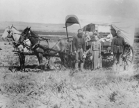
Homesteaders in central Nebraska in 1886
-
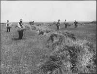
Wheat field near Mitchell, Nebraska
-
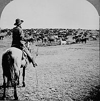
Cattle herd and cowboy, around 1902


Life on the Plains

The railroads made it possible to ship wheat and other crops cheaply to cities in the East and overseas. Homestead land was free for American settlers. Railroads also sold their land cheaply to immigrants, hoping they would create more business once their farms were set up. Many immigrants came, especially from Germany and Scandinavia.
On the plains, it was rare for single men to run a farm or ranch alone. They needed a hardworking wife and many children to help with all the chores. In the early days, farm women worked outdoors to help their families survive. Later, as new technology like sewing and washing machines became available, women spent more time on household tasks.
Even though farm life on the prairies could seem lonely, people created busy social lives. They often had activities that combined work, food, and fun. These included barn raisings, corn huskings, quilting bees, Grange meetings, church events, and school functions. Women organized shared meals and visited each other's families.
The Great Plains in the 20th Century

The area around the Oklahoma Panhandle became known as the Dust Bowl in the late 1920s and early 1930s. This included parts of Colorado, Kansas, Texas, and New Mexico. A long drought, poor farming methods, and the financial problems of the Great Depression forced many farmers to leave their land across the Great Plains.
Since the 1950s, many parts of the Great Plains have become very productive for growing crops. This is thanks to a lot of irrigation on large farms. The United States now exports many agricultural products.
The southern Great Plains sits over the Ogallala Aquifer, a huge underground layer of water. Center pivot irrigation is used a lot in the drier parts of the Great Plains. However, this is using up the aquifer's water faster than it can be refilled naturally.
Population Changes
The rural areas of the Plains have lost a third of their population since 1920. Many areas have very few people living there, sometimes less than 2 inhabitants per square mile (0.77 inhabitants per square kilometer). This low population density was once used to define the American frontier.
There are over 6,000 ghost towns in Kansas alone. This problem is made worse because farms are getting bigger, and it's hard to attract new businesses to the region. Also, fewer school-aged children have led to schools closing in some communities. Some people suggest that farming in the drier parts of the Great Plains isn't sustainable. There's even a proposal to turn about 139,000 sq mi (360,000 km2) of these drier areas back into native prairie land.

Wind Power
The Great Plains is a very important area for wind power in the United States. Because it's so windy, many wind farms have been built here. Some people have suggested investing a lot of money to build even more wind power in the Plains. They believe this could help the U.S. get more of its energy from clean sources and boost the local economy.
Images for kids
-
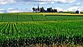
Farmland in Sioux and Lyon Counties, Iowa (2013)
-
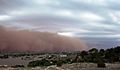
Dust cloud moving across the Llano Estacado near Ransom Canyon, Texas
-
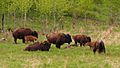
Herd of Plains Bison of various ages resting in Elk Island Park, Alberta
-
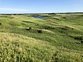
The Great Plains as seen in Minnesota's upland prairie at Glacial Lakes State Park
-
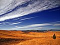
Short-grass prairie near the front range of the Rockies in Colorado
-
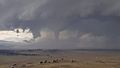
A tornado touching down in Park County, Colorado, July 23, 2018
-
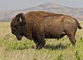
American bison (Bison bison), Wichita Mountain Wildlife Refuge, Oklahoma
-
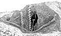
Excavation of a fossil Daemonelix burrow at Agate Fossil Beds National Monument.
-
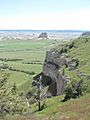
Scotts Bluff National Monument, Nebraska
-
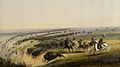
This painting by Alfred Jacob Miller is a portrayal of Plains Indians chasing buffalo over a small cliff. The Walters Art Museum.
-
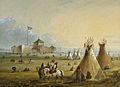
Fort William, the first Fort Laramie, as it looked prior to 1840. Painting from memory by Alfred Jacob Miller
-
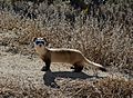
Black-footed ferret (Mustela nigripes) National Black-footed Ferret Conservation Center, Colorado
-
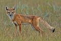
Swift fox (Vulpes velox), Colorado
-
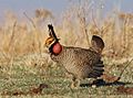
Lesser prairie-chicken (Tympanuchus pallidicinctus) on a lek in the Red Hills of Kansas
-
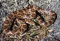
Great Plains ratsnake (Pantherophis emoryi), Missouri
-
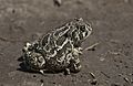
Great Plains toad (Anaxyrus cognatus)
.jpg)

.jpg)


_(15545351982).jpg)
.jpg)


_(cropped).jpg)
.jpg)
.jpg)
_(8726969667).jpg)
.jpg)
See also
 In Spanish: Grandes Llanuras para niños
