
Black Hills facts for kids
Quick facts for kids Black Hills |
|
|---|---|

The Needles, Black Hills
|
|
| Highest point | |
| Peak | Black Elk Peak |
| Elevation | 7,244 ft (2,208 m) NAVD 88 |
| Listing | Isolated summits of the United States |
| Dimensions | |
| Area | 5,000 sq mi (13,000 km2) |
| Naming | |
| Native name | Error {{native name}}: an IETF language tag as parameter {{{1}}} is required (help) |
| Geography | |

Black Hills
Location in the United States
|
|
| Country | United States |
| Geology | |
| Orogeny | Trans-Hudson and Laramide |
| Age of rock | Precambrian, Paleozoic, Mesozoic, Cenozoic and Tertiary |
| Type of rock | Shale, sandstone, limestone, slate, quartzite and granite |
The Black Hills are a group of mountains that stand out from the flat Great Plains in western South Dakota and eastern Wyoming, United States. Black Elk Peak is the highest point in these mountains, reaching 7,242 feet (2,207 m) high. The Lakota people call this area Pahá Sápa, which means "Black Mountains." The Black Hills are covered in evergreen trees, which make them look dark from far away. This is how they got their name.
The Black Hills are home to the Black Hills National Forest. These mountains formed when ancient rocks pushed up from underground. Over millions of years, water and wind wore down the higher parts, creating the mountains we see today.
Native American tribes have lived in the Black Hills for a very long time. They consider the area a sacred place. After the Lakota people became the main group in the area in 1776, the Black Hills became very important to their culture. In 1868, the U.S. government signed a treaty. This treaty said the Black Hills would belong to the Lakota people forever. It also said that no settlers could live there.
However, in 1874, American settlers found gold in the Black Hills. This happened during an expedition led by George Armstrong Custer. A gold rush quickly brought many miners to the area. After the Great Sioux War of 1876, the U.S. government took control of the Black Hills. They moved the Lakota people to smaller reservations in South Dakota. Unlike most of South Dakota, many of the early settlers in the Black Hills came from places to the west and south. These were miners who had already been part of gold rushes in Colorado and Montana.
Today, the Black Hills economy relies less on mining and timber. Instead, hotels, restaurants, and tourism are very important. Locals often divide the Black Hills into two parts: "The Southern Hills" and "The Northern Hills."
The Southern Hills has many famous spots. These include Mount Rushmore National Memorial, Wind Cave National Park, Jewel Cave National Monument, and Black Elk Peak. Custer State Park is also there, which is the largest state park in South Dakota. You can also find the Crazy Horse Memorial and The Mammoth Site in Hot Springs. This site is the world's largest place for studying mammoths.
In the Northern Hills, popular places include Spearfish Canyon and historic Deadwood. The Sturgis Motorcycle Rally happens here every August. The first rally was in 1938. In 2015, over one million bikers visited the Black Hills for the 75th Rally. Devils Tower National Monument is nearby in Wyoming. It was the first national monument in the United States.
Contents
History of the Black Hills
Early Times
Scientists use special methods to learn about the early history of the Black Hills. They use carbon-dating on old tools. This shows that people lived here as far back as 11,500 BC. These early people were part of the Clovis culture.
Scientists also study layers of soil and rock. These layers show how the environment changed over time, like with floods and droughts. For example, big floods in the Black Hills usually happen about once every 100 years. But during a warm period long ago, called the Medieval Warm Period, floods happened more often. In 400 years, there were thirteen big floods in four areas. In the 800 years before that, there were only nine floods in the same areas.

Native American History
The Arikara people arrived in the Black Hills around the year 1500. Later, other tribes like the Cheyenne, Crow, Kiowa, and Arapaho also came to live there. In the 1700s, the Lakota (also called Sioux) arrived from Minnesota. They became the main group in the area. They called the land Ȟe Sápa, meaning "Black Mountains." This is how the mountains became known as the Black Hills.
Exploration and Settlement


In 1743, French explorers François and Louis de La Vérendrye likely traveled near the Black Hills. Later, fur trappers and traders also visited the area. They traded with the Native American tribes living there.
More and more American settlers started moving into Lakota lands. To make sure settlers could travel safely on the Oregon Trail, the U.S. government signed the Fort Laramie Treaty in 1868. This treaty created the Great Sioux Reservation and said the Black Hills belonged to Native Americans. The treaty promised to protect the Black Hills "forever" from American settlers. Both the Sioux and Cheyenne tribes believed the Black Hills were a very sacred place, like the center of the world.
People had heard rumors of gold in the Black Hills for many years. But it was confirmed in 1874. That year, George Armstrong Custer led an expedition and found gold in French Creek. Newspaper reporters with the expedition shared the news. The next year, a group called the Newton-Jenney Party made the first detailed map of the Black Hills. Their surveyor, Valentine McGillycuddy, was the first European American to climb to the top of Black Elk Peak.
From 1875 to 1878, thousands of miners came to the Black Hills during the Black Hills Gold Rush. By 1880, it was the most crowded part of the Dakota Territory. Three big towns grew in the Northern Hills: Deadwood, Central City, and Lead. Smaller mining camps and villages grew around them. In the Southern Hills, Hill City and Custer City appeared. Railroads were quickly built to reach this remote area. Gold mines produced about $4 million each year, and silver mines produced about $3 million each year.
The Black Hills and the U.S. Government

The fight over who controlled the Black Hills led to the Black Hills War in 1876. This was the last major war on the Great Plains. After the Lakota and their allies were defeated, the United States took control of the Black Hills. Even though they were moved, the Lakota people never agreed that the U.S. government had the right to take their land. They have continued to try to get the Black Hills back. They also filed a lawsuit against the U.S. government.
In 1980, the Supreme Court of the United States ruled that the U.S. government had taken the Black Hills illegally. The court ordered the government to pay the Lakota people nearly $106 million. This money was for the original value of the land plus interest. However, the Lakota people refused to take the money. They wanted their land returned to them instead. The money is still in an account that earns interest. As of 2011, the amount was about $1 billion. The Lakota people have not accepted it because doing so would mean they give up their claim to the Black Hills.
In 2012, a United Nations expert visited Native American lands in the U.S. He looked into how the U.S. was following the United Nations Declaration on the Rights of Indigenous Peoples. He learned about a sale of over 1,900 acres of land in the Black Hills. This land included Pe' Sla, a sacred site for many tribes. Native Americans raised money to buy this land. In 2013, the U.S. government confirmed that several tribes had bought the Pe' Sla site. In 2016, more land at Pe' Sla was officially recognized as Native American trust land. In 2017, Pennington County agreed to give up its claim to the Pe' Sla area. Also, in 2016 and 2018, several tribes bought land near the sacred Bear Butte site.
Geology of the Black Hills

The Black Hills have a very interesting geology. About 60 million years ago, a mountain-building event pushed up the land. This event also caused volcanic activity in the northern Black Hills. The center of the Black Hills is made of very old rocks, like granite and metamorphic rocks. These rocks are about 1.8 billion years old.
Around this core, there are rings of different types of sedimentary rocks. These layers are like a target, with each ring made of a different rock type.
Oldest Rocks (Precambrian)

The very center of the Black Hills is called the granite core. This granite formed from hot liquid rock deep underground. It is about 1.8 billion years old. Some other very old rocks in the northern hills are even older, up to 2.8 billion years old.
Around the granite core is a ring of metamorphic rocks. These rocks are also very old, about 2 billion years or more. They were once sedimentary rocks. But a huge collision between landmasses caused them to fold and twist into a mountain range. Over millions of years, these tilted rocks wore away. Today, we can see where these old rocks meet younger layers in a sharp, angled line.

Middle Rocks (Paleozoic)
The next layers are sedimentary rocks. The oldest of these is the Deadwood Formation. This rock is mostly sandstone and was the source of gold found near Deadwood. Above it is the Pahasapa limestone. This limestone is where over 200 caves in the Black Hills formed, including Jewel Cave and Wind Cave. Other layers include the Minnelusa Formation, which has different sandstones and limestones, and the Opeche shale and Minnekahta limestone.
Younger Rocks (Mesozoic)
The next rock layer is the Spearfish Formation. This forms a valley around the hills called the Red Valley. It is mostly red shale with layers of gypsum. These shale and gypsum layers are used to make cement in Rapid City. Above this are the Sundance Formation (shale and sandstone), the Morrison Formation, and the Unkpapa sandstone.
The outer edge of the Black Hills dome is a ridge. This ridge is made of the Lakota Formation and the Fallriver sandstone. Above these, the rock layers are mostly grey shale. But there are three exceptions: the Newcastle sandstone, the Greenhorn limestone (which has many shark teeth fossils), and the Niobrara Formation (made of chalk). These outer ridges are called cuestas.
Newest Rocks (Cenozoic)

All the rock layers mentioned before were laid down flat. But a period of uplift pushed them up to form the Black Hills. This uplift began about 60 million years ago. It also created a line of igneous rocks through the northern hills. This line goes from Bear Butte in the east to Devils Tower in the west.
The Black Hills also have a "skirt" of gravel in some areas. These gravel layers formed as rivers cut down into the rising hills. They show where rivers used to flow. Most of these gravel beds are about 10,000 years old or newer. Some older gravels, up to 20 million years old, have been found in higher places.
Life in the Black Hills (Biosystems)

The Black Hills have a wide variety of plants and animals. Most of the hills are covered in ponderosa pine forests. In cool, moist valleys in the Northern Hills, you can find Black Hills spruce trees. There are also large open grasslands scattered throughout the hills, especially in the western part. The southern edge of the hills is drier, with a mix of pine trees and grasslands.
The wildlife is very diverse. Black Hills creeks are known for their trout fish. The forests and grasslands are home to American bison, white-tailed and mule deer, pronghorn, bighorn sheep, and mountain lions. You can also find many smaller animals like prairie dogs, American martens, and different types of squirrels.
The Black Hills are a special meeting place for different species. You can find animals and plants common to areas east, west, north, and south of the hills. Some animals are found only in the Black Hills. These include a type of white-winged junco bird, a snail, a snake, and a vole (a small rodent). Some birds like the pinyon jay and three-toed woodpecker live only in the Black Hills in South Dakota.
Regions of the Black Hills
The Black Hills can be divided into different areas. The northern Black Hills are mostly in Lawrence and Meade Counties. The central Black Hills are in Pennington County, west of Rapid City. The southern Black Hills are in Custer and Fall River Counties. The Wyoming part of the Black Hills is in Weston and Crook Counties.
The Elk Mountains are a smaller mountain range. They are in the southwest part of the region but are geologically separate from the main Black Hills.
Tourism and Economy


The Black Hills are a major tourist destination. Many famous landmarks are located here:
- Mount Rushmore National Memorial
- Wind Cave National Park
- Jewel Cave National Monument
- Black Elk Peak
- Custer State Park (one of the largest state parks in the U.S.)
- Bear Butte State Park
- Devils Tower National Monument
- Crazy Horse Memorial
The Sturgis Motorcycle Rally is held every August in the Black Hills. It started in 1940. In 2005, over 550,000 bikers visited the Black Hills for the rally. This event is a very important part of the local economy.
The George S. Mickelson Trail is a popular path through the Black Hills. It follows an old railroad track from Edgemont to Deadwood. This trail is about 110 miles (180 km) long. Hikers, cross-country skiers, and cyclists can use it.
Today, the largest city in the Black Hills is Rapid City. It has about 75,000 people. Rapid City serves as a business center for a large area. Besides tourism and mining, the Black Hills economy includes ranching (raising sheep and cattle), timber (lumber), Ellsworth Air Force Base, and some manufacturing. This manufacturing includes Black Hills gold jewelry, cement, electronics, and guns.
The Black Hills region feels like a spread-out urban area. It has a population of about 250,000 people, not counting tourists. Other important towns and cities in the Black Hills are:
- Belle Fourche: A town known for ranching.
- Custer: A town with mining and tourism, and the main office for Black Hills National Forest.
- Deadwood: A historic town famous for gambling.
- Hill City: A timber and tourism town in the center of the Hills. Here, the Black Hills Central Railroad runs old steam trains.
- Hot Springs: An old resort town in the southern Hills.
- Keystone: A tourism town right next to Mount Rushmore.
- Lead: Home to the former Homestake Mine (gold) and the Sanford Underground Research Facility.
- Newcastle: A center for oil production and refining in the Black Hills.
- Spearfish: Home to Black Hills State University.
- Sturgis: Originally a military town.
Images for kids
-
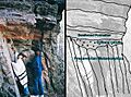
The angled line where the Deadwood Formation meets the older Precambrian rocks near Rapid City.
See also
 In Spanish: Colinas Negras para niños
