
Wind Cave National Park facts for kids
Quick facts for kids Wind Cave National Park |
|
|---|---|
|
IUCN Category II (National Park)
|
|

Skyway Lake
|
|

Wind Cave National Park
Location in South Dakota

Wind Cave National Park
Location in the United States
|
|
| Location | Custer County, South Dakota, US |
| Nearest city | Hot Springs, South Dakota |
| Area | 33,847 acres (136.97 km2) |
| Established | January 9, 1903 |
| Visitors | 489,399 (in 2024) |
| Governing body | National Park Service |
| Website | Wind Cave National Park |
Wind Cave National Park is a special national park in the United States. It is located about 10 miles (16 km) north of Hot Springs in western South Dakota. President Theodore Roosevelt created it on January 3, 1903. It was the sixth national park in the U.S. and the very first cave in the world to become a national park!
This cave is famous for its unique rock formations. These include calcite structures called boxwork and delicate frostwork. About 95% of all the boxwork formations ever found are right here in Wind Cave.
Wind Cave is known as a "breathing cave" because air moves in and out of it. It's also one of the most packed cave systems in the world. This means it has many passages in a small area. Wind Cave is the sixth longest cave in the world. As of 2025, explorers have mapped 168.02 miles (270.40 km) of its passages. It is the third longest cave in the United States. However, it is the second longest in Custer County, South Dakota, after Jewel Cave. Even though they are close, no one has found a connection between Wind Cave and Jewel Cave. Most scientists believe they are not connected.
Above ground, the park has the largest natural mixed-grass prairie left in the U.S. It also marks the southern end of the South Dakota Centennial Trail.
Contents
Why is it Called Wind Cave?
The cave's passages "breathe" because air constantly flows in or out. This happens to balance the air pressure inside the cave with the air pressure outside. When the air pressure outside is higher, air rushes into the cave. This makes the cave's pressure match the outside. When the air pressure inside the cave is higher, air flows out. This lowers the pressure inside the cave.
A big cave like Wind Cave with only a few small openings will "breathe" more noticeably. Western South Dakota often has quick weather changes. These changes cause fast shifts in air pressure. If a storm was coming when the Bingham brothers found the cave, the air pressure would have been dropping fast. This would make the cave's higher-pressure air rush out. This strong wind is how Wind Cave got its name.
History of Wind Cave
The Lakota, Cheyenne, and other Native American tribes knew about the cave. They traveled and camped around the area. Early European settlers also knew about it. But there is no record of anyone actually going inside the cave.
The Lakota people, who live in the Black Hills, called it Washun Niya. This means "breathing hole." They saw it as a sacred place. They believed it was where they first came out of the underworld. Their stories tell of Tokahe, the first human to emerge from the cave. This story is a big part of Lakota history and their origin story.
The areas around Wind Cave were important to native people for more than just spiritual reasons. They called it a "supermarket" because it provided many resources. During winter, these areas were perfect for camps. Many animals they hunted preferred the shelter of the cave. This made these spots ideal for Lakota settlements and hunting grounds.
Over time, the Lakota people lost their land. This was a common pattern for native peoples across the country. In 1851, a treaty was made with the U.S. government. Another treaty in 1868 changed the borders of Lakota land. It also allowed forts to be built on their land. In 1874, General George A. Custer surveyed the land. He wrongly reported a lot of gold, even though his geologist said there wasn't much.
Miners then rushed into the hills looking for gold. This went against the treaty with the Lakota. The government did little to stop these actions. In 1875, the Lakota's claim to the land was said to be invalid. This was because they supposedly lacked buildings and were "wasting" the land. When the Dawes Act passed in 1877, the land was opened to settlers. This led to the Lakota losing their ancestral lands.
White Americans first officially found the cave in 1881. Brothers Tom and Jesse Bingham heard wind blowing from a 10-inch by 14-inch (25 cm by 36 cm) hole. The story says that when Tom looked into the hole, the wind blew his hat off!
From 1881 to 1889, few people explored deep into Wind Cave. Then, in 1889, the South Dakota Mining Company hired Jesse D. McDonald. He was to manage their mining claim at the cave. The company might have hoped to find valuable minerals. Or, they might have planned to open the cave for tourists from the start.
No valuable minerals were found. So, the McDonald family began preparing the cave for visitors. Jesse first hired his son Alvin (who was 16 in 1890). Then, in 1891, he hired Alvin's brother Elmer. They explored and helped get the cave ready. Alvin loved the cave and kept a diary about it. Other people who worked and explored the cave between 1890 and 1903 included Katie Stabler, Emma McDonald (Elmer's wife), Inez McDonald (Emma and Elmer's daughter), and Tommy McDonald (Alvin and Elmer's brother).
By February 1892, the cave was open for visitors. A tour usually cost $1.00. This would be about $30 today. Tourists explored the cave by candlelight on guided tours. These early tours were tough. Sometimes, people had to crawl through tight spaces.
Like the nearby Jewel Cave National Monument, Jan and Herb Conn were important cave explorers in the 1960s.
Park Location
The park is in an unincorporated area of Custer County. The closest town is Hot Springs, which is in Fall River County.
Animals and Plants

Wind Cave National Park protects many different plants and animals. These include species from both eastern and western parts of the country. Animals living here are raccoons, elk, bison, coyotes, skunks, badgers, ermines, black-footed ferrets, cougars, bobcats, red foxes, minks, whooping crane, pronghorn, and prairie dogs.
The Wind Cave bison herd is one of only four wild and pure bison herds in North America. The other three are in Yellowstone Park, the Henry Mountains in Utah, and Elk Island in Canada. The Wind Cave bison herd is currently free of a disease called brucellosis.
Endangered Species in the Park
-
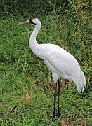
Whooping Crane
-
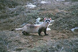
Black-footed ferret


The black-footed ferret and whooping crane are on the endangered species list. This means they are at risk of disappearing forever. The whooping crane population in Wind Cave National Park needs help to survive.
Climate and Weather
| Climate data for Wind Cave, South Dakota (1991–2020 normals, extremes 1990–present) | |||||||||||||
|---|---|---|---|---|---|---|---|---|---|---|---|---|---|
| Month | Jan | Feb | Mar | Apr | May | Jun | Jul | Aug | Sep | Oct | Nov | Dec | Year |
| Record high °F (°C) | 69 (21) |
69 (21) |
77 (25) |
89 (32) |
92 (33) |
102 (39) |
105 (41) |
101 (38) |
103 (39) |
89 (32) |
76 (24) |
66 (19) |
105 (41) |
| Mean maximum °F (°C) | 57.5 (14.2) |
57.7 (14.3) |
69.3 (20.7) |
77.3 (25.2) |
84.6 (29.2) |
91.8 (33.2) |
96.0 (35.6) |
94.7 (34.8) |
91.3 (32.9) |
79.7 (26.5) |
67.2 (19.6) |
56.9 (13.8) |
97.7 (36.5) |
| Mean daily maximum °F (°C) | 39.7 (4.3) |
40.7 (4.8) |
50.0 (10.0) |
57.7 (14.3) |
66.4 (19.1) |
77.4 (25.2) |
84.7 (29.3) |
83.6 (28.7) |
76.2 (24.6) |
61.4 (16.3) |
48.4 (9.1) |
39.4 (4.1) |
60.5 (15.8) |
| Daily mean °F (°C) | 27.2 (−2.7) |
28.1 (−2.2) |
36.8 (2.7) |
44.3 (6.8) |
53.7 (12.1) |
63.8 (17.7) |
70.7 (21.5) |
69.2 (20.7) |
61.2 (16.2) |
47.7 (8.7) |
35.9 (2.2) |
27.4 (−2.6) |
47.2 (8.4) |
| Mean daily minimum °F (°C) | 14.8 (−9.6) |
15.5 (−9.2) |
23.7 (−4.6) |
30.9 (−0.6) |
40.9 (4.9) |
50.1 (10.1) |
56.6 (13.7) |
54.9 (12.7) |
46.2 (7.9) |
34.0 (1.1) |
23.4 (−4.8) |
15.4 (−9.2) |
33.9 (1.1) |
| Mean minimum °F (°C) | −9.6 (−23.1) |
−8.3 (−22.4) |
1.2 (−17.1) |
14.6 (−9.7) |
26.0 (−3.3) |
37.6 (3.1) |
45.8 (7.7) |
42.8 (6.0) |
31.5 (−0.3) |
15.1 (−9.4) |
1.5 (−16.9) |
−7.2 (−21.8) |
−18.2 (−27.9) |
| Record low °F (°C) | −30 (−34) |
−32 (−36) |
−20 (−29) |
1 (−17) |
15 (−9) |
30 (−1) |
38 (3) |
31 (−1) |
23 (−5) |
−2 (−19) |
−15 (−26) |
−27 (−33) |
−32 (−36) |
| Average precipitation inches (mm) | 0.45 (11) |
0.70 (18) |
1.07 (27) |
2.32 (59) |
3.74 (95) |
3.29 (84) |
3.01 (76) |
2.30 (58) |
1.53 (39) |
1.55 (39) |
0.71 (18) |
0.53 (13) |
21.20 (538) |
| Average snowfall inches (cm) | 6.3 (16) |
7.1 (18) |
9.6 (24) |
7.8 (20) |
0.9 (2.3) |
0.0 (0.0) |
0.0 (0.0) |
0.0 (0.0) |
0.2 (0.51) |
2.1 (5.3) |
4.4 (11) |
7.5 (19) |
45.9 (117) |
| Average precipitation days (≥ 0.01 in) | 4.5 | 5.8 | 6.0 | 9.4 | 11.2 | 11.4 | 9.7 | 8.5 | 6.3 | 7.0 | 4.1 | 3.8 | 87.7 |
| Average snowy days (≥ 0.1 in) | 3.9 | 4.9 | 3.5 | 2.8 | 0.5 | 0.0 | 0.0 | 0.0 | 0.1 | 1.1 | 2.7 | 3.6 | 23.1 |
| Source: NOAA | |||||||||||||
The Great Plains have seen temperatures rise over the years. Wind Cave is in this region, so it is also affected. The average temperature increase across the plains has been two degrees Fahrenheit. Some areas have seen increases as high as five degrees Fahrenheit. This warming trend is expected to cause drought-like conditions in the area.
Park Facilities and Trails
Several roads go through the park. There are also 30 miles (48 km) of hiking trails on the surface. In 2018, about 656,397 people visited the park. More than 109,000 people toured the cave itself in 2015. This was the most since 1968, when cave tours were limited to 40 people each.
The Wind Cave visitor center has three exhibit rooms. These rooms teach about the cave's geology and early history. They also cover the park's wildlife and natural history. You can also learn about the work of the Civilian Conservation Corps in the park.
Elk Mountain Campground is in a ponderosa pine forest. It is about 1.25 miles (2 km) from the visitor center. The campground has 75 spots for tents and RVs. It is open all year. Campfire programs are offered in the summer. Limited services are available in the winter.
How the Cave Formed

The three levels of Wind Cave are in the top 76 meters (250 feet) of the Mississippian Pahasapa Limestone. This limestone formed in an ancient inland sea. Layers of chert, gypsum, and anhydrite within the limestone show times of high evaporation. When sea levels dropped, the limestone dissolved. This created a landscape with sinkholes and caves.
Later, red sands and clays filled some of these spaces. Others were coated with sparkling crystals called dogtooth spar. Over time, more rock layers formed above. Then, erosion removed some of these layers. During a period of mountain building called the Laramide Orogeny, the land lifted. This caused the water level to drop, draining and enlarging the cave system. Today, the water level is 150 meters (490 feet) below the surface.
Boxwork formations were first found in Wind Cave. These calcite fins were once cracks filled with gypsum and anhydrite. The gypsum dissolved, leaving the calcite fins sticking out from the rock. These intersecting fins create open chambers. They can stick out from 0.6 to 1.2 meters (2 to 4 feet). Lower parts of the cave have boxwork mixed with frostwork and cave popcorn. Unique twisted formations called helictite bushes were also first found here. You can also find moonmilk on many surfaces and calcite rafts in the lower cave levels.
Wind Cave in Popular Culture
During a political debate in 2019, Senator Amy Klobuchar mentioned Wind Cave. She said, "I’ve been to the Wind Cave in South Dakota, which I suggest you go to." This helped promote tourism to Wind Cave National Park.
The cave is also featured in Dan Jorgensen's novel And the Wind Whispered.
Images for kids
-
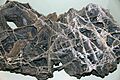
Calcite boxwork removed from the cave; Field Museum of Natural History, Chicago
-
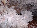
Frostwork and popcorn formations
-
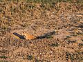
A prairie dog; part of an extensive colony in the park
-

Flora of the prairie
-
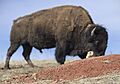
Bison and prairie dogs are commonplace in the park.


See also
 In Spanish: Parque nacional Wind Cave para niños
- List of national parks of the United States
- Carlsbad Caverns National Park
- Jewel Cave National Monument
- Great Basin National Park (Lehman Caves)
- Lava Beds National Monument (lava tubes)
- Mammoth Cave National Park
- Oregon Caves National Monument
- Russell Cave National Monument
- Timpanogos Cave National Monument
- List of longest caves in the United States
- List of longest caves
