Fall River County, South Dakota facts for kids
Quick facts for kids
Fall River County
|
|
|---|---|

|
|

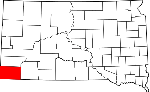
Location within the U.S. state of South Dakota
|
|
 South Dakota's location within the U.S. |
|
| Country | |
| State | |
| Founded | April 3, 1883 |
| Named for | Fall River |
| Seat | Hot Springs |
| Largest city | Hot Springs |
| Area | |
| • Total | 1,749 sq mi (4,530 km2) |
| • Land | 1,740 sq mi (4,500 km2) |
| • Water | 9.2 sq mi (24 km2) 0.5% |
| Population
(2020)
|
|
| • Total | 6,973 |
| • Estimate
(2023)
|
7,393 |
| • Density | 3.9868/sq mi (1.5393/km2) |
| Time zone | UTC−7 (Mountain) |
| • Summer (DST) | UTC−6 (MDT) |
| Congressional district | At-large |
Fall River County is a county in South Dakota. In 2020, about 6,973 people lived there. Its main town, called the county seat, is Hot Springs. The county started in 1883. It's named after the Fall River, which flows through the area.
Contents
Exploring Fall River County's Geography
Fall River County is in the southwest corner of South Dakota. It shares borders with Nebraska to the south and Wyoming to the west. The county has mountains in its north-central part. The rest of the county has rolling hills.
The highest point in the county is in the southwest corner. It is about 3,970 feet (1,210 meters) above sea level. One mountain peak in the northeast part of the county is about 4,646 feet (1,416 meters) high. The land generally slopes down towards the north and east. The Cheyenne River flows through the upper part of the county. It leaves the county to the north, going into Custer County.
Fall River County covers a total area of about 1,749 square miles (4,530 square kilometers). Most of this area, about 1,740 square miles (4,500 square kilometers), is land. Only a small part, about 9.2 square miles (24 square kilometers), is water.
Major Roads in Fall River County
These are the main highways that run through Fall River County:
 US 18
US 18 US 385
 SD 71
SD 71 SD 79
SD 79 SD 89
SD 89 SD 471
Neighboring Counties
Fall River County shares its borders with these other counties:
- Custer County to the north
- Oglala Lakota County to the east
- Dawes County, Nebraska to the southeast
- Sioux County, Nebraska to the south
- Niobrara County, Wyoming to the west
Protected Natural Areas
Fall River County is home to several protected areas. These places help keep nature safe and offer outdoor activities:
- Angostura Reservoir State Game Production Area
- Angostura State Recreation Area
- Bailey State Lakeside Use Area
- Battle Mountain State Game Production Area
- Black Hills National Forest (part of it)
- Buffalo Gap National Grassland (part of it)
- Friendshuh State Game Production Area (part of it)
- Hill Ranch State Game Production Area
- Oral State Game Production Area
- Romey State Game Production Area
- Scherbarth State Game Production Area
- Sheps Canyon State Lakeside Use Area
- Sheps Canyon State Recreation Area
- Williams Dam State Game Production
Lakes and Water Bodies
You can find these lakes in Fall River County:
- Angostura Reservoir
- Coldbrook Lake
- Cottonwood Springs Lake
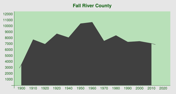
Understanding Fall River County's Population
| Historical population | |||
|---|---|---|---|
| Census | Pop. | %± | |
| 1890 | 4,478 | — | |
| 1900 | 3,541 | −20.9% | |
| 1910 | 7,763 | 119.2% | |
| 1920 | 6,985 | −10.0% | |
| 1930 | 8,741 | 25.1% | |
| 1940 | 8,089 | −7.5% | |
| 1950 | 10,439 | 29.1% | |
| 1960 | 10,688 | 2.4% | |
| 1970 | 7,505 | −29.8% | |
| 1980 | 8,439 | 12.4% | |
| 1990 | 7,353 | −12.9% | |
| 2000 | 7,453 | 1.4% | |
| 2010 | 7,094 | −4.8% | |
| 2020 | 6,973 | −1.7% | |
| 2023 (est.) | 7,393 | 4.2% | |
| U.S. Decennial Census 1790-1960 1900-1990 1990-2000 2010-2020 |
|||
Population in 2020
According to the 2020 census, 6,973 people lived in Fall River County. There were 3,226 households and 1,891 families. This means there were about 4.0 people per square mile. There were also 4,081 housing units, which are homes or apartments.
Population in 2010
In the 2010 census, Fall River County had 7,094 people. There were 3,272 households and 1,899 families. The population density was about 4.1 people per square mile. Most people (88.6%) were white. About 7.1% were Native American. A small number of people were from other racial backgrounds. About 2.2% of the population was of Hispanic or Latino origin.
Many people in the county had German (39.7%) or Irish (12.6%) backgrounds. Other common ancestries included English, Norwegian, and Dutch.
About 20.4% of households had children under 18 living with them. About 46.2% of households were married couples. The average household had 2.10 people. The average family had 2.74 people. The average age of people in the county was 50.5 years old.
The average income for a household was $35,833. For families, the average income was $53,750. About 17.4% of all people in the county lived below the poverty line. This included 11.3% of those under 18 and 21.3% of those aged 65 or older.
Communities in Fall River County
Fall River County has several towns and communities.
Cities
Town
Census-Designated Places
These are areas that are like towns but are not officially incorporated as cities or towns:
- Angostura
- Ardmore
- Dudley
- Maverick Junction
- Oral
- Provo
- Smithwick
Other Communities
Some other places in the county include:
Townships
Townships are smaller local government areas:
- Argentine
- Provo
- Robins
Unorganized Territories
These are areas that do not have their own local government:
- Northeast Fall River
- Southwest Fall River
See also
 In Spanish: Condado de Fall River para niños
 | Emma Amos |
 | Edward Mitchell Bannister |
 | Larry D. Alexander |
 | Ernie Barnes |


