Niobrara County, Wyoming facts for kids
Quick facts for kids
Niobrara County
|
|
|---|---|
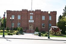
Stagecoach Museum in Lusk
|
|
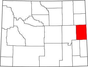
Location within the U.S. state of Wyoming
|
|
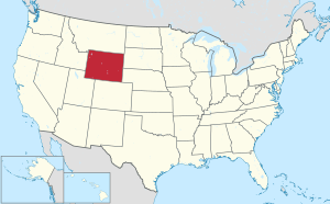 Wyoming's location within the U.S. |
|
| Country | |
| State | |
| Founded | February 21, 1911 (authorized) 1913 (organized) |
| Named for | Niobrara River |
| Seat | Lusk |
| Largest town | Lusk |
| Area | |
| • Total | 2,628 sq mi (6,810 km2) |
| • Land | 2,626 sq mi (6,800 km2) |
| • Water | 1.9 sq mi (5 km2) 0.07%% |
| Population
(2020)
|
|
| • Total | 2,467 |
| • Density | 0.9387/sq mi (0.36245/km2) |
| Time zone | UTC−7 (Mountain) |
| • Summer (DST) | UTC−6 (MDT) |
| Congressional district | At-large |
Niobrara County is a county in the state of Wyoming, USA. It is special because it has the fewest people of all the counties in Wyoming. In 2020, only 2,467 people lived there. The main town and county seat is Lusk. The county's eastern side touches the states of Nebraska and South Dakota.
Contents
History of Niobrara County
Niobrara County was officially created on February 21, 1911. It was formed from land that used to be part of Converse County. The county was fully set up and ready to go in 1913.
The county got its name from the Niobrara River. This river starts its journey not far from the town of Lusk.
Geography of Niobrara County
According to the US Census Bureau, Niobrara County covers a total area of about 2,628 square miles (6,806 square kilometers). Most of this area, about 2,626 square miles (6,801 square kilometers), is land. Only a very small part, about 1.9 square miles (4.9 square kilometers), is water.
To give you an idea of its size, Niobrara County is more than twice as big as the entire state of Rhode Island. However, it has only a tiny fraction of Rhode Island's population.
Neighboring Counties
Niobrara County shares its borders with several other counties:
- Weston County – to the north
- Custer County, South Dakota – to the northeast
- Fall River County, South Dakota – to the east
- Sioux County, Nebraska – to the southeast
- Goshen County – to the south
- Platte County – to the southwest
- Converse County – to the west
Main Roads
Several important highways pass through Niobrara County:
 US 18
US 18 US 20
US 20 US 85
US 85 WYO 270
 WYO 271
 WYO 272
 WYO 273
Protected Natural Areas
A part of the Thunder Basin National Grassland is located within Niobrara County. This is a large area of protected grasslands.
Population and People
| Historical population | |||
|---|---|---|---|
| Census | Pop. | %± | |
| 1920 | 6,321 | — | |
| 1930 | 4,723 | −25.3% | |
| 1940 | 5,988 | 26.8% | |
| 1950 | 4,701 | −21.5% | |
| 1960 | 3,750 | −20.2% | |
| 1970 | 2,924 | −22.0% | |
| 1980 | 2,924 | 0.0% | |
| 1990 | 2,499 | −14.5% | |
| 2000 | 2,407 | −3.7% | |
| 2010 | 2,484 | 3.2% | |
| 2020 | 2,467 | −0.7% | |
| 2023 (est.) | 2,354 | −5.2% | |
| US Decennial Census 1870–2000 2010–2016 |
|||
In 2010, there were 2,484 people living in Niobrara County. These people lived in 1,069 households. About 659 of these households were families. The county had a population density of less than one person per square mile.
Most of the people in the county were white (96.5%). Smaller groups included American Indian, Asian, and Black or African American people. About 2.1% of the population was of Hispanic or Latino background. Many residents had ancestors from Germany (41.5%), England (19.0%), or Ireland (17.7%).
The average age of people in Niobrara County in 2010 was 46.1 years old. About 23.2% of households had children under 18 living with them.
Communities in Niobrara County
Niobrara County has several towns and communities.
Towns
- Lusk (This is the county seat, meaning it's the main administrative town.)
- Manville
- Van Tassell
Census-designated place
- Lance Creek (This is a community that the Census Bureau defines for statistical purposes.)
Unincorporated communities
- Keeline
- Riverview
Education in Niobrara County
All the schools in Niobrara County are part of one school district. This district is called Niobrara County School District 1.
See also
 In Spanish: Condado de Niobrara para niños
 | Calvin Brent |
 | Walter T. Bailey |
 | Martha Cassell Thompson |
 | Alberta Jeannette Cassell |


